

432
A.H. Schumann and G.A. Schultz
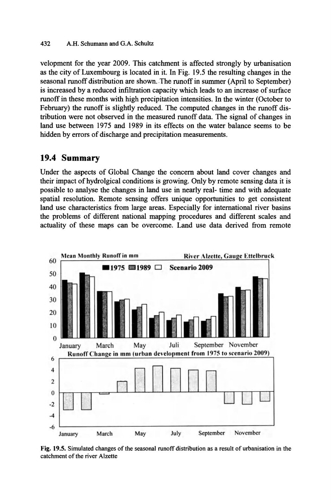
velopment for the year 2009. This catchment is affected strongly by urbanisation
as the city of Luxembourg is located in it. In Fig. 19.5 the resulting changes in the
seasonal runoff distribution are shown. The runoff in summer (April to September)
is increased by a reduced infiltration capacity which leads to an increase of surface
runoff in these months with high precipitation intensities. In the winter (October to
February) the runoff is slightly reduced. The computed changes in the runoff distribution were not observed in the measured runoff data. The signal of changes in
land use between 1975 and 1989 in its effects on the water balance seems to be
hidden by errors of discharge and precipitation measurements.
19.4 Summary
Under the aspects of Global Change the concern about land cover changes and
their impact ofhydrolgical conditions is growing. Only by remote sensing data it is
possible to analyse the changes in land use in nearly real- time and with adequate
spatial resolution. Remote sensing offers unique opportunities to get consistent
land use characteristics from large areas. Especially for international river basins
the problems of different national mapping procedures and different scales and
actuality of these maps can be overcome. Land use data derived from remote
60
50
40
30
20
iO
0
6
4
2
o
-2
-4
-6
Mean Mon
River
Ettelbruck
1989 D Scenario 2009
January
March
May
Juli
September November
RUlloff C hange in Inlll (urll;ln development from 1975 to srenario 2009)
January
March
May
Ju ly
September
November
Fig. 19.5. Simulated changes of the seasonal runoff distribution as a result of urbanisation in the
catchment of the river Alzette
A.H. Schumann and G.A. Schultz
velopment for the year 2009. This catchment is affected strongly by urbanisation
as the city of Luxembourg is located in it. In Fig. 19.5 the resulting changes in the
seasonal runoff distribution are shown. The runoff in summer (April to September)
is increased by a reduced infiltration capacity which leads to an increase of surface
runoff in these months with high precipitation intensities. In the winter (October to
February) the runoff is slightly reduced. The computed changes in the runoff distribution were not observed in the measured runoff data. The signal of changes in
land use between 1975 and 1989 in its effects on the water balance seems to be
hidden by errors of discharge and precipitation measurements.
19.4 Summary
Under the aspects of Global Change the concern about land cover changes and
their impact ofhydrolgical conditions is growing. Only by remote sensing data it is
possible to analyse the changes in land use in nearly real- time and with adequate
spatial resolution. Remote sensing offers unique opportunities to get consistent
land use characteristics from large areas. Especially for international river basins
the problems of different national mapping procedures and different scales and
actuality of these maps can be overcome. Land use data derived from remote
60
50
40
30
20
iO
0
6
4
2
o
-2
-4
-6
Mean Mon
River
Ettelbruck
1989 D Scenario 2009
January
March
May
Juli
September November
RUlloff C hange in Inlll (urll;ln development from 1975 to srenario 2009)
January
March
May
Ju ly
September
November
Fig. 19.5. Simulated changes of the seasonal runoff distribution as a result of urbanisation in the
catchment of the river Alzette