

430
A.H. Schumann and G.A. Schultz
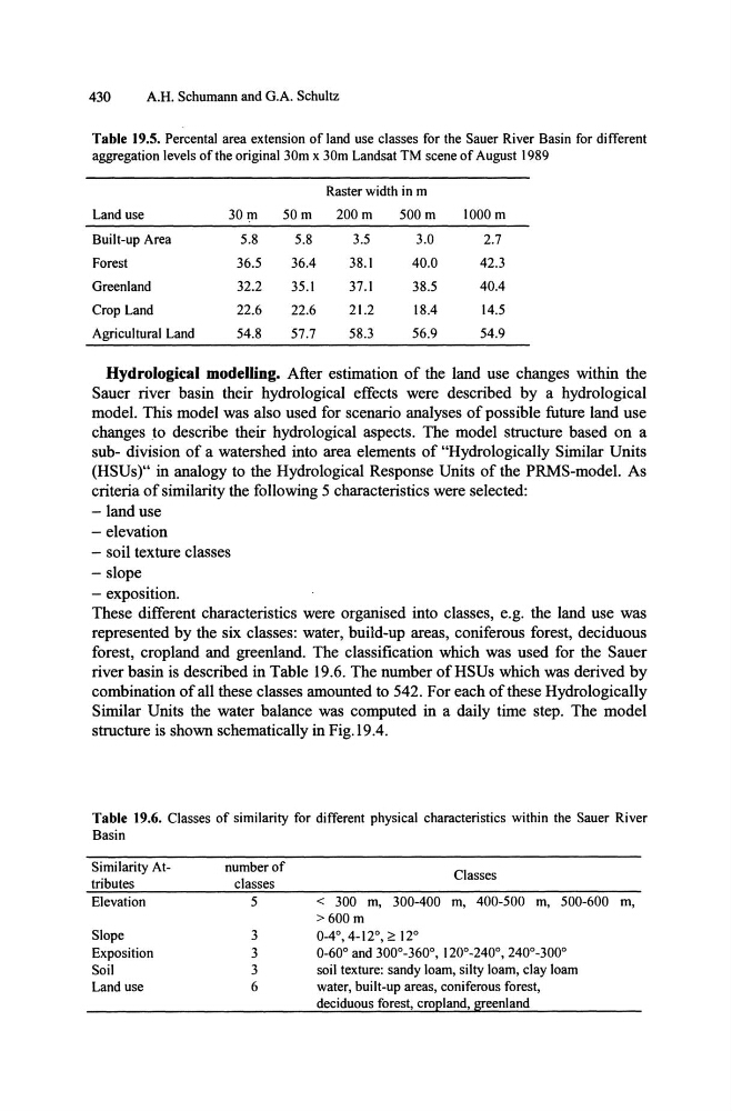
Table 19.5. Percental area extension of land use classes for the Sauer River Basin for different
aggregation levels of the original 30m x 30m Landsat TM scene of August 1989
Raster width in m
Land use
30 In
50m
200m
500m
1000 m
Built-up Area
5.8
5.8
3.5
3.0
2.7
Forest
36.5
36.4
38.1
40.0
42.3
Greenland
32.2
35.1
37.1
38.5
40.4
Crop Land
22.6
22.6
21.2
18.4
14.5
Agricultural Land
54.8
57.7
58.3
56.9
54.9
Hydrological modelling. After estimation of the land use changes within the
Sauer river basin their hydrological effects were described by a hydrological
model. This model was also used for scenario analyses of possible future land use
changes to describe their hydrological aspects. The model structure based on a
sub- division of a watershed into area elements of "Hydrologically Similar Units
(HSUs)" in analogy to the Hydrological Response Units of the PRMS-model. As
criteria of similarity the following 5 characteristics were selected:
-land use
- elevation
- soil texture classes
- slope
- exposition.
These different characteristics were organised into classes, e.g. the land use was
represented by the six classes: water, build-up areas, coniferous forest, deciduous
forest, cropland and greenland. The classification which was used for the Sauer
river basin is described in Table 19.6. The number of HSUs which was derived by
combination of all these classes amounted to 542. For each of these Hydrologically
Similar Units the water balance was computed in a daily time step. The model
structure is shown schematically in Fig. 19.4.
Table 19.6. Classes of similarity for different physical characteristics within the Sauer River
Basin
Similarity Attributes
Elevation
Slope
Exposition
Soil
Land use
number of
classes
5
3
3
3
6
Classes
< 300 m, 300-400 m, 400-500 m, 500-600 m,
>600m
0-4°,4-12°,2:12°
0-60° and 300°-360°, 120°-240°,240°-300°
soil texture: sandy loam, silty loam, clay loam
water, built-up areas, coniferous forest,
deciduous forest, cropland, greenland
A.H. Schumann and G.A. Schultz
Table 19.5. Percental area extension of land use classes for the Sauer River Basin for different
aggregation levels of the original 30m x 30m Landsat TM scene of August 1989
Raster width in m
Land use
30 In
50m
200m
500m
1000 m
Built-up Area
5.8
5.8
3.5
3.0
2.7
Forest
36.5
36.4
38.1
40.0
42.3
Greenland
32.2
35.1
37.1
38.5
40.4
Crop Land
22.6
22.6
21.2
18.4
14.5
Agricultural Land
54.8
57.7
58.3
56.9
54.9
Hydrological modelling. After estimation of the land use changes within the
Sauer river basin their hydrological effects were described by a hydrological
model. This model was also used for scenario analyses of possible future land use
changes to describe their hydrological aspects. The model structure based on a
sub- division of a watershed into area elements of "Hydrologically Similar Units
(HSUs)" in analogy to the Hydrological Response Units of the PRMS-model. As
criteria of similarity the following 5 characteristics were selected:
-land use
- elevation
- soil texture classes
- slope
- exposition.
These different characteristics were organised into classes, e.g. the land use was
represented by the six classes: water, build-up areas, coniferous forest, deciduous
forest, cropland and greenland. The classification which was used for the Sauer
river basin is described in Table 19.6. The number of HSUs which was derived by
combination of all these classes amounted to 542. For each of these Hydrologically
Similar Units the water balance was computed in a daily time step. The model
structure is shown schematically in Fig. 19.4.
Table 19.6. Classes of similarity for different physical characteristics within the Sauer River
Basin
Similarity Attributes
Elevation
Slope
Exposition
Soil
Land use
number of
classes
5
3
3
3
6
Classes
< 300 m, 300-400 m, 400-500 m, 500-600 m,
>600m
0-4°,4-12°,2:12°
0-60° and 300°-360°, 120°-240°,240°-300°
soil texture: sandy loam, silty loam, clay loam
water, built-up areas, coniferous forest,
deciduous forest, cropland, greenland