

14 Groundwater
309
14.2.2 Groundwater surface
The next important step is the reconstruction of the groundwater table at a selected
time of the year, by using a topographic map, head data from wells and
information on base flow, in order to differentiate influent or effluent streams with
due consequences for the intersection of the groundwater table with the river beds.
Head elevations have to be accurate and a common problem is to determine the
altitudes if no field levelling can be done. By radar interferometry high accuracy
can be obtained if comer reflectors are used. Otherwise, ground conditions
(moisture content, vegetation, etc.) should not change between two recordings, a
situation not often met in practice.
Image interpretations are used to locate areas where the groundwater table is
probably shallow. The appearance of groundwater at or near the surface is caused
by either the intersection of topographic depressions and a static phreatic
groundwater level, or by a discharge zone of an upwelling groundwater flow
system. In both cases there will be an effect on vegetation, relative soil moisture,
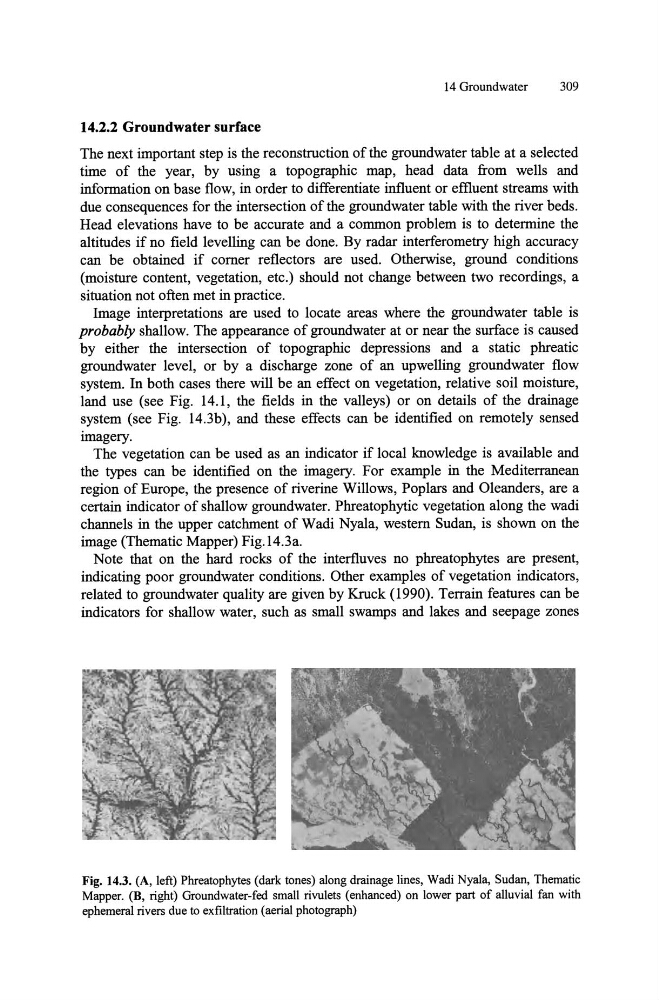
land use (see Fig. 14.1, the fields in the valleys) or on details of the drainage
system (see Fig. 14.3b), and these effects can be identified on remotely sensed
imagery.
The vegetation can be used as an indicator if local Imowledge is available and
the types can be identified on the imagery. For example in the Mediterranean
region of Europe, the presence of riverine Willows, Poplars and Oleanders, are a
certain indicator of shallow groundwater. Phreatophytic vegetation along the wadi
channels in the upper catchment of Wadi Nyala, western Sudan, is shown on the
image (Thematic Mapper) Fig. 14.3a.
Note that on the hard rocks of the interfluves no phreatophytes are present,
indicating poor groundwater conditions. Other examples of vegetation indicators,
related to groundwater quality are given by Kruck (1990). Terrain features can be
indicators for shallow water, such as small swamps and lakes and seepage zones
Fig. 14.3. (A, left) Phreatophytes (dark tones) along drainage lines, Wadi Nyala, Sudan, Thematic
Mapper. (B, right) Groundwater-fed small rivulets (enhanced) on lower part of alluvial fan with
ephemeral rivers due to exfiltration (aerial photograph)
309
14.2.2 Groundwater surface
The next important step is the reconstruction of the groundwater table at a selected
time of the year, by using a topographic map, head data from wells and
information on base flow, in order to differentiate influent or effluent streams with
due consequences for the intersection of the groundwater table with the river beds.
Head elevations have to be accurate and a common problem is to determine the
altitudes if no field levelling can be done. By radar interferometry high accuracy
can be obtained if comer reflectors are used. Otherwise, ground conditions
(moisture content, vegetation, etc.) should not change between two recordings, a
situation not often met in practice.
Image interpretations are used to locate areas where the groundwater table is
probably shallow. The appearance of groundwater at or near the surface is caused
by either the intersection of topographic depressions and a static phreatic
groundwater level, or by a discharge zone of an upwelling groundwater flow
system. In both cases there will be an effect on vegetation, relative soil moisture,
land use (see Fig. 14.1, the fields in the valleys) or on details of the drainage
system (see Fig. 14.3b), and these effects can be identified on remotely sensed
imagery.
The vegetation can be used as an indicator if local Imowledge is available and
the types can be identified on the imagery. For example in the Mediterranean
region of Europe, the presence of riverine Willows, Poplars and Oleanders, are a
certain indicator of shallow groundwater. Phreatophytic vegetation along the wadi
channels in the upper catchment of Wadi Nyala, western Sudan, is shown on the
image (Thematic Mapper) Fig. 14.3a.
Note that on the hard rocks of the interfluves no phreatophytes are present,
indicating poor groundwater conditions. Other examples of vegetation indicators,
related to groundwater quality are given by Kruck (1990). Terrain features can be
indicators for shallow water, such as small swamps and lakes and seepage zones
Fig. 14.3. (A, left) Phreatophytes (dark tones) along drainage lines, Wadi Nyala, Sudan, Thematic
Mapper. (B, right) Groundwater-fed small rivulets (enhanced) on lower part of alluvial fan with
ephemeral rivers due to exfiltration (aerial photograph)