

252
A. Rango, A.E. Walker and B.E. Goodison
providing the capability to discriminate wet snow areas from snow-free areas and
hence a more accurate retrieval of snow extent during melting conditions.
The Climate Research Branch prairie SWE algorithm has been applied to Nimbus-7
SMMR and DMSP SSMII data to create a 20 year time series of maps depicting
winter SWE conditions over the Canadian prairie region, for the purpose of investigating seasonal and interannual variability in support of the Branch's climate research
activities in assessing climate variability and change. Walker et al. (1995) presents the
SMMR time series in the form of an atlas. Colour Plates II.A and 11.B are two
winter snowpack extremes from the SSMII time series, which contributed to drought
conditions in summer 1988 and flooding in areas of Manitoba and Alberta in spring
1997, illustrating the extremes in SWE that can be experienced in this region.
11.3.3 Snowmelt Runoff Forecast Operations
Very few hydrological models have been developed to be compatible with remote
sensing data. One of the few models that was developed requiring direct remote
sensing input is the Snowmelt Runoff Model (SRM) (Martinec et al., 1998). SRM
requires remote sensing measurements of the snow covered area in a basin. Although
aircraft observations can be used, satellite-derived snow cover extent is the most
common.
Two versions of SRM are now available. The most commonly-used version employs the degree day approach to melting the snow cover in a basin (Martinec et al.,
1998). To date, this version ofSRM has been tested on over 80 basins in 25 countries
worldwide. This version of SRM has also been frequently used for forecasting. Each
day, the water produced from snoWmelt and from rainfall is computed, superimposed
on the calculated recession flow, and transformed into daily discharge from the basin
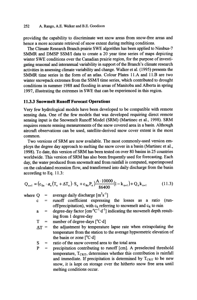
according to Eq. 11.3:
where Q
c
a
T
~T =
S
P
(11.3)
average daily discharge [m 3 s- l ]
runoff coefficient expressing the losses as a ratio (runoff/precipitation), with Cs referring to snowmelt and CR to rain
degree-day factor [cm·°C-I·d- l ] indicating the snowmelt depth resulting from 1 degree-day
number of degree-days [OC·d]
the adjustment by temperature lapse rate when extrapolating the
temperature from the station to the average hypsometric elevation of
the basin or zone [OC·d]
ratio of the snow covered area to the total area
precipitation contributing to runoff [cm]. A preselected threshold
temperature, TCRIT, determines whether this contribution is rainfall
and immediate. If precipitation is determined by T CRIT to be new
snow, it is kept on storage over the hitherto snow free area until
melting conditions occur.
A. Rango, A.E. Walker and B.E. Goodison
providing the capability to discriminate wet snow areas from snow-free areas and
hence a more accurate retrieval of snow extent during melting conditions.
The Climate Research Branch prairie SWE algorithm has been applied to Nimbus-7
SMMR and DMSP SSMII data to create a 20 year time series of maps depicting
winter SWE conditions over the Canadian prairie region, for the purpose of investigating seasonal and interannual variability in support of the Branch's climate research
activities in assessing climate variability and change. Walker et al. (1995) presents the
SMMR time series in the form of an atlas. Colour Plates II.A and 11.B are two
winter snowpack extremes from the SSMII time series, which contributed to drought
conditions in summer 1988 and flooding in areas of Manitoba and Alberta in spring
1997, illustrating the extremes in SWE that can be experienced in this region.
11.3.3 Snowmelt Runoff Forecast Operations
Very few hydrological models have been developed to be compatible with remote
sensing data. One of the few models that was developed requiring direct remote
sensing input is the Snowmelt Runoff Model (SRM) (Martinec et al., 1998). SRM
requires remote sensing measurements of the snow covered area in a basin. Although
aircraft observations can be used, satellite-derived snow cover extent is the most
common.
Two versions of SRM are now available. The most commonly-used version employs the degree day approach to melting the snow cover in a basin (Martinec et al.,
1998). To date, this version ofSRM has been tested on over 80 basins in 25 countries
worldwide. This version of SRM has also been frequently used for forecasting. Each
day, the water produced from snoWmelt and from rainfall is computed, superimposed
on the calculated recession flow, and transformed into daily discharge from the basin
according to Eq. 11.3:
where Q
c
a
T
~T =
S
P
(11.3)
average daily discharge [m 3 s- l ]
runoff coefficient expressing the losses as a ratio (runoff/precipitation), with Cs referring to snowmelt and CR to rain
degree-day factor [cm·°C-I·d- l ] indicating the snowmelt depth resulting from 1 degree-day
number of degree-days [OC·d]
the adjustment by temperature lapse rate when extrapolating the
temperature from the station to the average hypsometric elevation of
the basin or zone [OC·d]
ratio of the snow covered area to the total area
precipitation contributing to runoff [cm]. A preselected threshold
temperature, TCRIT, determines whether this contribution is rainfall
and immediate. If precipitation is determined by T CRIT to be new
snow, it is kept on storage over the hitherto snow free area until
melting conditions occur.