

11 Snow and Ice
241
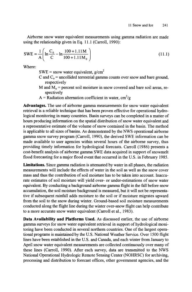
Airborne snow water equivalent measurements using gamma radiation are made
using the relationship given in Eq. 11.1 (Carroll, 1990):
SWE =~(ln..s..-ln 100+1.I1M )
A
C
100 + 1.11 Mo
(11.1)
Where:
SWE = snow water equivalent, g/cm2
C and Co = uncollided terrestrial gamma counts over snow and bare ground,
respectively
M and Mo = percent soil moisture in snow covered and bare soil areas, respectively
A = Radiation alternation coefficient in water, cm 2 /g
Advantages. The use of airborne gamma measurements for snow water equivalent
retrieval is a reliable technique that has been proven effective for operational hydrological monitoring in many countries. Basin surveys can be completed in a matter of
hours producing information on the spatial distribution of snow water equivalent and
a representative estimate of the volume of snow contained in the basin. The method
is applicable to all sizes of basins. As demonstrated by the NWS operational airborne
gamma snow survey program (Carroll, 1990), the derived SWE information can be
made available to user agencies within several hours of the airborne survey, thus
providing timely information for hydrological forecasts. Carroll (1986) presents a
cost-benefit analysis of airborne gamma SWE data acquired in support of snowmelt
flood forecasting for a major flood event that occurred in the U.S. in February 1985.
Limitations. Since gamma radiation is attenuated by water in all phases, the radiation
measurements will include the effects of water in the soil as well as the snow cover
mass and thus the contribution of soil moisture has to be taken into account. Inaccurate estimates of soil moisture will yield over- or under-estimations of snow water
equivalent. By conducting a background airborne gamma flight in the fall before snow
accumulation, the soil moisture background is measured, but it will not be representative if subsequent rainfall adds moisture to the soil or if moisture migrates upward
from the soil to the snow during winter. Ground-based soil moisture measurements
conducted along the flight line during the winter over-snow flight can help contribute
to a more accurate snow water equivalent (Carroll et aI., 1983).
Data Availability and Platforms Used. As discussed earlier, the use of airborne
gamma surveys for snow water equivalent retrieval in support of hydrological monitoring have been conducted in several northern countries. One of the largest operational programs is maintained by the U.S. National Weather Service. Over 1500 flight
lines have been established in the U.S. and Canada, and each winter from January to
April snow water equivalent measurements are collected continuously over many of
these lines (Carroll, 1990). After each survey, data are transmitted to the NWS
National Operational Hydrologic Remote Sensing Center (NOHRSC) for archiving,
processing and distribution to forecast offices, other government agencies, and the
241
Airborne snow water equivalent measurements using gamma radiation are made
using the relationship given in Eq. 11.1 (Carroll, 1990):
SWE =~(ln..s..-ln 100+1.I1M )
A
C
100 + 1.11 Mo
(11.1)
Where:
SWE = snow water equivalent, g/cm2
C and Co = uncollided terrestrial gamma counts over snow and bare ground,
respectively
M and Mo = percent soil moisture in snow covered and bare soil areas, respectively
A = Radiation alternation coefficient in water, cm 2 /g
Advantages. The use of airborne gamma measurements for snow water equivalent
retrieval is a reliable technique that has been proven effective for operational hydrological monitoring in many countries. Basin surveys can be completed in a matter of
hours producing information on the spatial distribution of snow water equivalent and
a representative estimate of the volume of snow contained in the basin. The method
is applicable to all sizes of basins. As demonstrated by the NWS operational airborne
gamma snow survey program (Carroll, 1990), the derived SWE information can be
made available to user agencies within several hours of the airborne survey, thus
providing timely information for hydrological forecasts. Carroll (1986) presents a
cost-benefit analysis of airborne gamma SWE data acquired in support of snowmelt
flood forecasting for a major flood event that occurred in the U.S. in February 1985.
Limitations. Since gamma radiation is attenuated by water in all phases, the radiation
measurements will include the effects of water in the soil as well as the snow cover
mass and thus the contribution of soil moisture has to be taken into account. Inaccurate estimates of soil moisture will yield over- or under-estimations of snow water
equivalent. By conducting a background airborne gamma flight in the fall before snow
accumulation, the soil moisture background is measured, but it will not be representative if subsequent rainfall adds moisture to the soil or if moisture migrates upward
from the soil to the snow during winter. Ground-based soil moisture measurements
conducted along the flight line during the winter over-snow flight can help contribute
to a more accurate snow water equivalent (Carroll et aI., 1983).
Data Availability and Platforms Used. As discussed earlier, the use of airborne
gamma surveys for snow water equivalent retrieval in support of hydrological monitoring have been conducted in several northern countries. One of the largest operational programs is maintained by the U.S. National Weather Service. Over 1500 flight
lines have been established in the U.S. and Canada, and each winter from January to
April snow water equivalent measurements are collected continuously over many of
these lines (Carroll, 1990). After each survey, data are transmitted to the NWS
National Operational Hydrologic Remote Sensing Center (NOHRSC) for archiving,
processing and distribution to forecast offices, other government agencies, and the