

240
A. Rango, A.E. Walker and B.E. Goodison
Apr
May
Jun
Jul
Aug
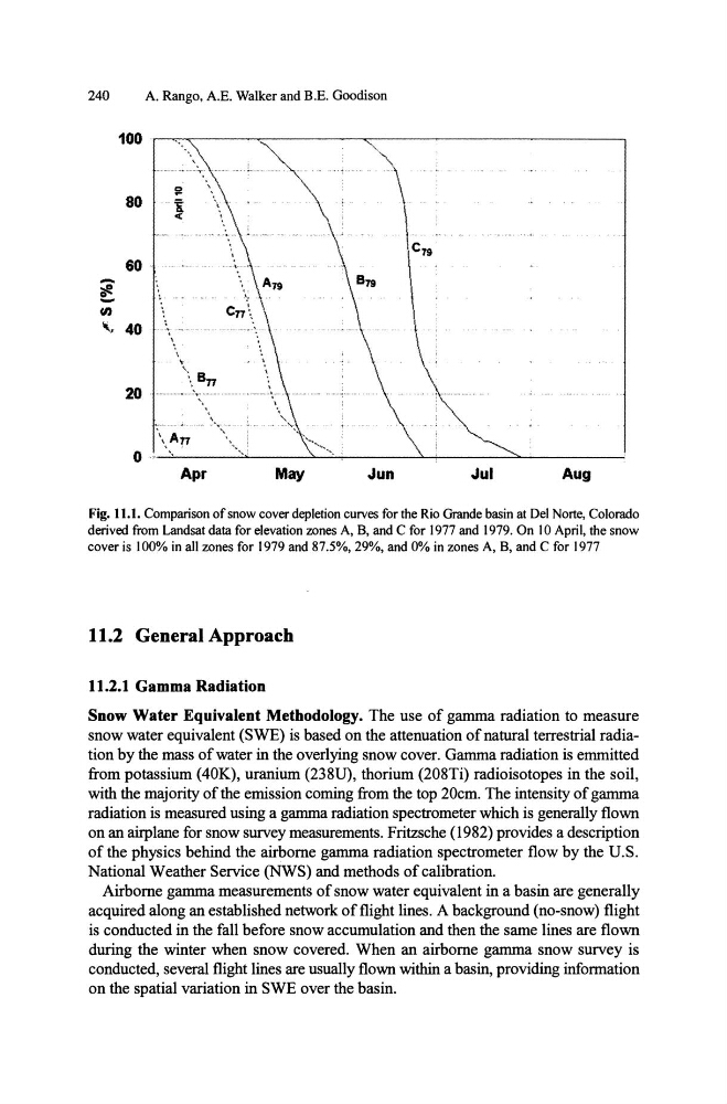
Fig. 11.1. Comparison of snow cover depletion curves for the Rio Grande basin at Del Norte, Colorado
derived from Landsat data for elevation zones A, B, and C for 1977 and 1979. On 10 April, the snow
cover is 100% in all zones for 1979 and 87.5%, 29%, and 0% in zones A, B, and C for 1977
11.2 General Approach
11.2.1 Gamma Radiation
Snow Water Equivalent Methodology. The use of gamma radiation to measure
snow water equivalent (SWE) is based on the attenuation of natural terrestrial radiation by the mass of water in the overlying snow cover. Gamma radiation is emmitted
from potassium (40K), uranium (238U), thorium (208Ti) radioisotopes in the soil,
with the majority of the emission coming from the top 20cm. The intensity of gamma
radiation is measured using a gamma radiation spectrometer which is generally flown
on an airplane for snow survey measurements. Fritzsche (1982) provides a description
of the physics behind the airborne gamma radiation spectrometer flow by the u.s.
National Weather Service (NWS) and methods of calibration.
Airborne gamma measurements of snow water equivalent in a basin are generally
acquired along an established network of flight lines. A background (no-snow) flight
is conducted in the fall before snow accumulation and then the same lines are flown
during the winter when snow covered. When an airborne gamma snow survey is
conducted, several flight lines are usually flown within a basin, providing information
on the spatial variation in SWE over the basin.
A. Rango, A.E. Walker and B.E. Goodison
Apr
May
Jun
Jul
Aug
Fig. 11.1. Comparison of snow cover depletion curves for the Rio Grande basin at Del Norte, Colorado
derived from Landsat data for elevation zones A, B, and C for 1977 and 1979. On 10 April, the snow
cover is 100% in all zones for 1979 and 87.5%, 29%, and 0% in zones A, B, and C for 1977
11.2 General Approach
11.2.1 Gamma Radiation
Snow Water Equivalent Methodology. The use of gamma radiation to measure
snow water equivalent (SWE) is based on the attenuation of natural terrestrial radiation by the mass of water in the overlying snow cover. Gamma radiation is emmitted
from potassium (40K), uranium (238U), thorium (208Ti) radioisotopes in the soil,
with the majority of the emission coming from the top 20cm. The intensity of gamma
radiation is measured using a gamma radiation spectrometer which is generally flown
on an airplane for snow survey measurements. Fritzsche (1982) provides a description
of the physics behind the airborne gamma radiation spectrometer flow by the u.s.
National Weather Service (NWS) and methods of calibration.
Airborne gamma measurements of snow water equivalent in a basin are generally
acquired along an established network of flight lines. A background (no-snow) flight
is conducted in the fall before snow accumulation and then the same lines are flown
during the winter when snow covered. When an airborne gamma snow survey is
conducted, several flight lines are usually flown within a basin, providing information
on the spatial variation in SWE over the basin.