

232
G. Kite and A. Pietroniro
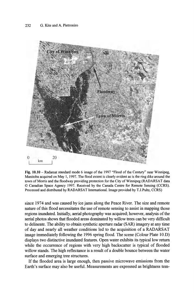
Fig. 10.10 - Radarsat standard mode 6 image of the 1997 "Flood of the Century" near Winnipeg,
Manitoba acquired on May I, 1997. The flood extent is clearly evident as is the ring dike around the
town of Monis and the floodway providing protection for the City of Winnipeg (RAD ARSA T data
© Canadian Space Agency 1997. Received by the Canada Centre for Remote Sensing (CCRS).
Processed and distributed by RADARSAT Internationai. Image provided by TJ.Pultz, CCRS)
since 1974 and was caused by ice jams along the Peace River. The size and remote
nature of this flood necessitates the use of remote sensing to assist in mapping those
regions inundated. Initially, aerial photography was acquired; however, analysis of the
aerial photos shows that flooded areas dominated by willow trees can be very difficult
to delineate. The ability to obtain synthetic aperture radar (SAR) imagery at any time
of day and nearly all weather conditions led to the acquisition of a RADARS A T
image immediately following the 1996 spring flood. The scene (Colour Plate IO.D)
displays two distinctive inundated features. Open water exhibits its typical low return
while the occurrence of regions with very high backscatter is typical of flooded
willow stands. The high reflectance is a result of a double bounce between the water
surface and emerging tree structures.
If the flooded area is large enough, then passive microwave emissions from the
Earth's surface may also be useful. Measurements are expressed as brightness tem-
G. Kite and A. Pietroniro
Fig. 10.10 - Radarsat standard mode 6 image of the 1997 "Flood of the Century" near Winnipeg,
Manitoba acquired on May I, 1997. The flood extent is clearly evident as is the ring dike around the
town of Monis and the floodway providing protection for the City of Winnipeg (RAD ARSA T data
© Canadian Space Agency 1997. Received by the Canada Centre for Remote Sensing (CCRS).
Processed and distributed by RADARSAT Internationai. Image provided by TJ.Pultz, CCRS)
since 1974 and was caused by ice jams along the Peace River. The size and remote
nature of this flood necessitates the use of remote sensing to assist in mapping those
regions inundated. Initially, aerial photography was acquired; however, analysis of the
aerial photos shows that flooded areas dominated by willow trees can be very difficult
to delineate. The ability to obtain synthetic aperture radar (SAR) imagery at any time
of day and nearly all weather conditions led to the acquisition of a RADARS A T
image immediately following the 1996 spring flood. The scene (Colour Plate IO.D)
displays two distinctive inundated features. Open water exhibits its typical low return
while the occurrence of regions with very high backscatter is typical of flooded
willow stands. The high reflectance is a result of a double bounce between the water
surface and emerging tree structures.
If the flooded area is large enough, then passive microwave emissions from the
Earth's surface may also be useful. Measurements are expressed as brightness tem-