

218
O. Kite and A. Pietroniro
The chapter then examines swface water levels (lakes and rivers) measured directly
from satellites and the possibility of converting these levels into flows. Remote
sensing is increasingly used for flood monitoring and the chapter describes the various
satellite sensors used for this purpose. Direct estimation of water levels and the
subsequent estimate of flow are not the only means of using remotely sensed data for
surface water applications. Data from satellite may also be used as input to hydrological models to simulate surface water levels and flows. The use of such models is
covered in more detail in Chap. 5; only a brief mention is included here.
There are many other excellent reports and conference proceedings, which include
descriptions of the use of remotely sensed data for measurement of swface water.
Examples of such publication include Hydrologic Applications of Space Technology
(Johnson 1996), Remote Sensing in Hydrology (Engman and Gurney, 1991), Remote
Sensing and Geographic Information Systems for Design and Operation of Water
Resources Systems (Baumgartner et aI., 1997) and a series of workshop proceedings
on the application of remote sensing to hydrology (Kite et aI., 1994; 1996). NERAC
(1993) contains a bibliography of citations on remote sensing of wetlands and
swamps.
10.2 Surface Water Detection
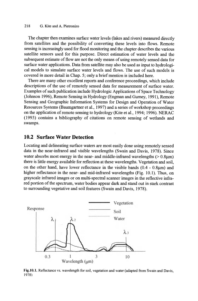
Locating and delineating surface waters are most easily done using remotely sensed
data in the near-infrared and visible wavelengths (Swain and Davis, 1978). Since
water absorbs most energy in the near- and middle-infrared wavelengths (> 0.8/lID)
there is little energy available for reflection at these wavelengths. Vegetation and soil,
on the other hand, have lower reflectance in the visible bands (0.4 - 0.8Jlm) and
higher reflectance in the near- and mid-infrared wavelengths (Fig. 10.1). Thus, on
grayscale infrared images or on multi-spectral scanner images in the reflective infrared portion of the spectrum, water bodies appear dark and stand out in stark contrast
to surrounding vegetative and soil features (Swain and Davis, 1978).
Vegetation
Re ponse
Soil
0.3
I
3
10
Wavelength (Jlm)
Fig.IO.1. Reflectance vs. wavelength for soil, vegetation and water (adapted from Swain and Davis,
1978)
O. Kite and A. Pietroniro
The chapter then examines swface water levels (lakes and rivers) measured directly
from satellites and the possibility of converting these levels into flows. Remote
sensing is increasingly used for flood monitoring and the chapter describes the various
satellite sensors used for this purpose. Direct estimation of water levels and the
subsequent estimate of flow are not the only means of using remotely sensed data for
surface water applications. Data from satellite may also be used as input to hydrological models to simulate surface water levels and flows. The use of such models is
covered in more detail in Chap. 5; only a brief mention is included here.
There are many other excellent reports and conference proceedings, which include
descriptions of the use of remotely sensed data for measurement of swface water.
Examples of such publication include Hydrologic Applications of Space Technology
(Johnson 1996), Remote Sensing in Hydrology (Engman and Gurney, 1991), Remote
Sensing and Geographic Information Systems for Design and Operation of Water
Resources Systems (Baumgartner et aI., 1997) and a series of workshop proceedings
on the application of remote sensing to hydrology (Kite et aI., 1994; 1996). NERAC
(1993) contains a bibliography of citations on remote sensing of wetlands and
swamps.
10.2 Surface Water Detection
Locating and delineating surface waters are most easily done using remotely sensed
data in the near-infrared and visible wavelengths (Swain and Davis, 1978). Since
water absorbs most energy in the near- and middle-infrared wavelengths (> 0.8/lID)
there is little energy available for reflection at these wavelengths. Vegetation and soil,
on the other hand, have lower reflectance in the visible bands (0.4 - 0.8Jlm) and
higher reflectance in the near- and mid-infrared wavelengths (Fig. 10.1). Thus, on
grayscale infrared images or on multi-spectral scanner images in the reflective infrared portion of the spectrum, water bodies appear dark and stand out in stark contrast
to surrounding vegetative and soil features (Swain and Davis, 1978).
Vegetation
Re ponse
Soil
0.3
I
3
10
Wavelength (Jlm)
Fig.IO.1. Reflectance vs. wavelength for soil, vegetation and water (adapted from Swain and Davis,
1978)