

and
RVI = NIR
R'
7 Land-use and Catchment Characteristics
137
(7.2)
where NIR and R are near-infrared (0.75 - 0.90 pm) and red (0.63 - 0-.70 pm)
reflection measurements, respectively.
180
soil line -- -160
140
Z 120
e.
u
100
i!?
e
:s 80
(ij
., 60
z
40
20
0
0
20
40
60
80
100 120 140 160 180 200
Red (ON)
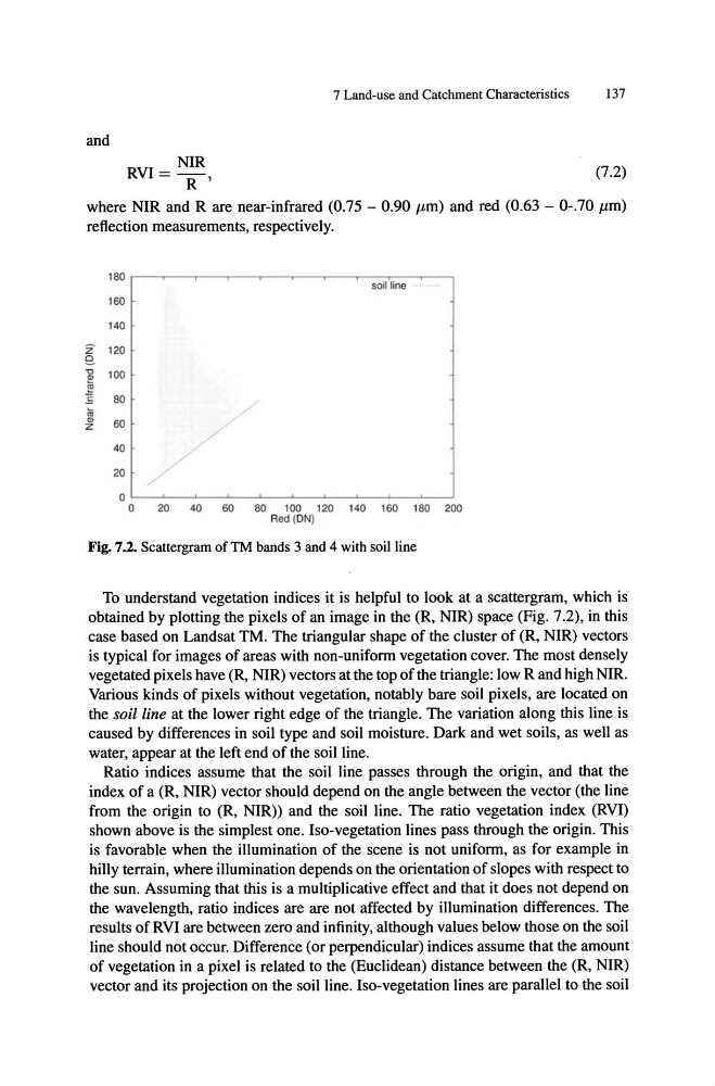
Fig. 7.2. Scattergram of TM bands 3 and 4 with soil line
To understand vegetation indices it is helpful to look at a scattergram, which is
obtained by plotting the pixels of an image in the (R, NIR) space (Fig. 7.2), in this
case based on Landsat TM. The triangular shape of the cluster of (R, NIR) vectors
is typical for images of areas with non-uniform vegetation cover. The most densely
vegetated pixels have (R, NIR) vectors at the top of the triangle: low R and high NIR.
Various kinds of pixels without vegetation, notably bare soil pixels, are located on
the soil line at the lower right edge of the triangle. The variation along this line is
caused by differences in soil type and soil moisture. Dark and wet soils, as well as
water, appear at the left end of the soil line.
Ratio indices assume that the soil line passes through the origin, and that the
index of a (R, NIR) vector should depend on the angle between the vector (the line
from the origin to (R, NIR)) and the soil line. The ratio vegetation index (RVI)
shown above is the simplest one. Iso-vegetation lines pass through the origin. This
is favorable when the illumination of the scene is not uniform, as for example in
hilly terrain, where illumination depends on the orientation of slopes with respect to
the sun. Assuming that this is a multiplicative effect and that it does not depend on
the wavelength, ratio indices are are not affected by illumination differences. The
results of RVI are between zero and infinity, although values below those on the soil
line should not occur. Difference (or perpendicular) indices assume that the amount
of vegetation in a pixel is related to the (Euclidean) distance between the (R, NIR)
vector and its projection on the soil line. Iso-vegetation lines are parallel to the soil
RVI = NIR
R'
7 Land-use and Catchment Characteristics
137
(7.2)
where NIR and R are near-infrared (0.75 - 0.90 pm) and red (0.63 - 0-.70 pm)
reflection measurements, respectively.
180
soil line -- -160
140
Z 120
e.
u
100
i!?
e
:s 80
(ij
., 60
z
40
20
0
0
20
40
60
80
100 120 140 160 180 200
Red (ON)
Fig. 7.2. Scattergram of TM bands 3 and 4 with soil line
To understand vegetation indices it is helpful to look at a scattergram, which is
obtained by plotting the pixels of an image in the (R, NIR) space (Fig. 7.2), in this
case based on Landsat TM. The triangular shape of the cluster of (R, NIR) vectors
is typical for images of areas with non-uniform vegetation cover. The most densely
vegetated pixels have (R, NIR) vectors at the top of the triangle: low R and high NIR.
Various kinds of pixels without vegetation, notably bare soil pixels, are located on
the soil line at the lower right edge of the triangle. The variation along this line is
caused by differences in soil type and soil moisture. Dark and wet soils, as well as
water, appear at the left end of the soil line.
Ratio indices assume that the soil line passes through the origin, and that the
index of a (R, NIR) vector should depend on the angle between the vector (the line
from the origin to (R, NIR)) and the soil line. The ratio vegetation index (RVI)
shown above is the simplest one. Iso-vegetation lines pass through the origin. This
is favorable when the illumination of the scene is not uniform, as for example in
hilly terrain, where illumination depends on the orientation of slopes with respect to
the sun. Assuming that this is a multiplicative effect and that it does not depend on
the wavelength, ratio indices are are not affected by illumination differences. The
results of RVI are between zero and infinity, although values below those on the soil
line should not occur. Difference (or perpendicular) indices assume that the amount
of vegetation in a pixel is related to the (Euclidean) distance between the (R, NIR)
vector and its projection on the soil line. Iso-vegetation lines are parallel to the soil