

5 Remote Sensing in Hydrological Modeling
97
responding remotely-sensed fields were also generated. A VHRR-derived variables
(air temperature, humidity and downwelling longwave radiation) were timeinterpolated to produce diurnal curves, as described earlier. The model was run at
a 3-hour time-step, first using ground data alone, and then using remotely-sensed
inputs.
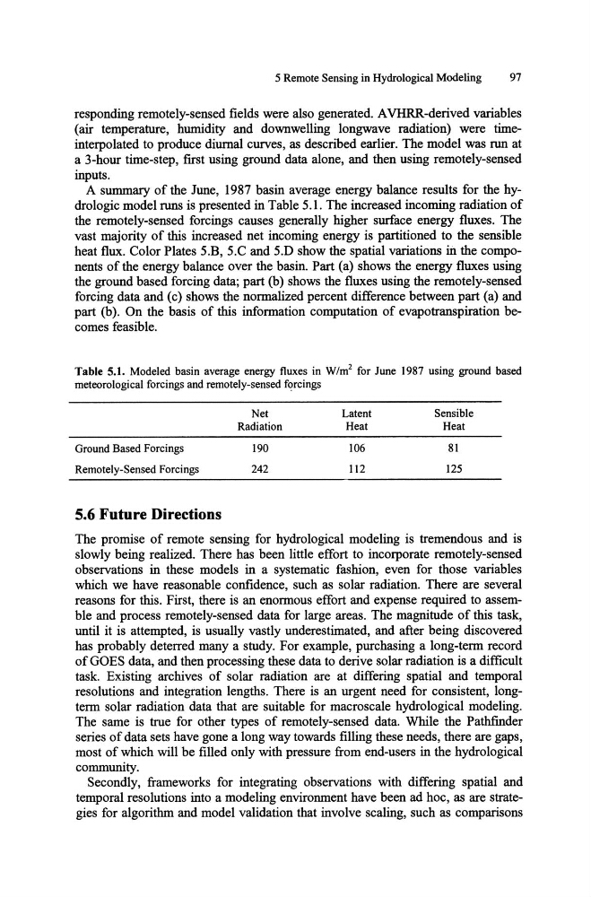
A summary of the June, 1987 basin average energy balance results for the hydrologic model runs is presented in Table 5.1. The increased incoming radiation of
the remotely-sensed forcings causes generally higher surface energy fluxes. The
vast majority of this increased net incoming energy is partitioned to the sensible
heat flux. Color Plates S.B, S.C and S.D show the spatial variations in the components of the energy balance over the basin. Part (a) shows the energy fluxes using
the ground based forcing data; part (b) shows the fluxes using the remotely-sensed
forcing data and (c) shows the normalized percent difference between part (a) and
part (b). On the basis of this information computation of evapotranspiration becomes feasible.
Table 5.1. Modeled basin average energy fluxes in W/m2 for June 1987 using ground based
meteorological forcings and remotely-sensed forcings
Ground Based Forcings
Remotely-Sensed Forcings
5.6 Future Directions
Net
Radiation
190
242
Latent
Heat
106
112
Sensible
Heat
81
125
The promise of remote sensing for hydrological modeling is tremendous and is
slowly being realized. There has been little effort to incorporate remotely-sensed
observations in these models in a systematic fashion, even for those variables
which we have reasonable confidence, such as solar radiation. There are several
reasons for this. First, there is an enormous effort and expense required to assemble and process remotely-sensed data for large areas. The magnitude of this task,
until it is attempted, is usually vastly underestimated, and after being discovered
has probably deterred many a study. For example, purchasing a long-term record
of GOES data, and then processing these data to derive solar radiation is a difficult
task. Existing archives of solar radiation are at differing spatial and temporal
resolutions and integration lengths. There is an urgent need for consistent, longterm solar radiation data that are suitable for macro scale hydrological modeling.
The same is true for other types of remotely-sensed data. While the Pathfinder
series of data sets have gone a long way towards filling these needs, there are gaps,
most of which will be filled only with pressure from end-users in the hydrological
community.
Secondly, frameworks for integrating observations with differing spatial and
temporal resolutions into a modeling environment have been ad hoc, as are strategies for algorithm and model validation that involve scaling, such as comparisons
97
responding remotely-sensed fields were also generated. A VHRR-derived variables
(air temperature, humidity and downwelling longwave radiation) were timeinterpolated to produce diurnal curves, as described earlier. The model was run at
a 3-hour time-step, first using ground data alone, and then using remotely-sensed
inputs.
A summary of the June, 1987 basin average energy balance results for the hydrologic model runs is presented in Table 5.1. The increased incoming radiation of
the remotely-sensed forcings causes generally higher surface energy fluxes. The
vast majority of this increased net incoming energy is partitioned to the sensible
heat flux. Color Plates S.B, S.C and S.D show the spatial variations in the components of the energy balance over the basin. Part (a) shows the energy fluxes using
the ground based forcing data; part (b) shows the fluxes using the remotely-sensed
forcing data and (c) shows the normalized percent difference between part (a) and
part (b). On the basis of this information computation of evapotranspiration becomes feasible.
Table 5.1. Modeled basin average energy fluxes in W/m2 for June 1987 using ground based
meteorological forcings and remotely-sensed forcings
Ground Based Forcings
Remotely-Sensed Forcings
5.6 Future Directions
Net
Radiation
190
242
Latent
Heat
106
112
Sensible
Heat
81
125
The promise of remote sensing for hydrological modeling is tremendous and is
slowly being realized. There has been little effort to incorporate remotely-sensed
observations in these models in a systematic fashion, even for those variables
which we have reasonable confidence, such as solar radiation. There are several
reasons for this. First, there is an enormous effort and expense required to assemble and process remotely-sensed data for large areas. The magnitude of this task,
until it is attempted, is usually vastly underestimated, and after being discovered
has probably deterred many a study. For example, purchasing a long-term record
of GOES data, and then processing these data to derive solar radiation is a difficult
task. Existing archives of solar radiation are at differing spatial and temporal
resolutions and integration lengths. There is an urgent need for consistent, longterm solar radiation data that are suitable for macro scale hydrological modeling.
The same is true for other types of remotely-sensed data. While the Pathfinder
series of data sets have gone a long way towards filling these needs, there are gaps,
most of which will be filled only with pressure from end-users in the hydrological
community.
Secondly, frameworks for integrating observations with differing spatial and
temporal resolutions into a modeling environment have been ad hoc, as are strategies for algorithm and model validation that involve scaling, such as comparisons