

5 Remote Sensing in Hydrological Modeling
93
rithms exist for both clear and cloudy sky conditions, including Gautier et al.
(1980), Cess and Vulius (1989), Frouin et. al (1989), Bishop and Rossow (1991),
Pinker and Laszlo (1992), and Gautier and Landsfeld (1997). These algorithms
typically use the at-sensor radiance along with climatological, surficial and atmospheric information to determine incoming and net solar radiation.
There are several issues with GOES data that are worth mentioning. First, the
resulting 1 km insolation fields generated by the radiation codes are generally not
appropriate for driving macroscale models. A particular terrain element will not
just see the portion of the sky corresponding to the field of view of the sensor, but
will receive energy from the entire overlaying hemisphere. Secondly, clouds move
with time. Hence, the instantaneous flux as determined from the GOES data are
not representative of the time-integrated fluxes usually used to drive models (e.g.
hourly-integrated fluxes from pyranometers). Lastly, the navigation of GOES data
generally is not precise so that the exact location on the ground corresponding to
particular pixel is not known. For all these reasons, some form of aggregation of
the data is required (Dubayah and Loechel, 1997)
5.4.2 Downwelling longwave
Downwelling longwave radiation (L W ..l-) from the atmosphere is difficult to estimate from remotely-sensed data. It is dependent on several factors including
clouds, air temperature, surface temperature, surface and atmospheric emissivity,
near surface humidity, and the water vapor and temperature lapse rates. Several
empirical and semi-empirical relationships exist which relate air temperature and
humidity at shelter height, and in some cases cloudiness, to downwelling longwave
(e.g. Brutsaert 1975; Unsworth and Monteith 1975). Zhong et al. (1990) have
shown that differences among some of these techniques are small, on the order of 6
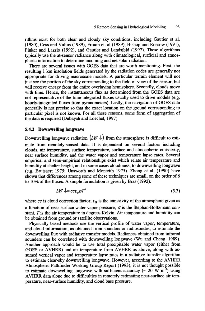
to 10% of the fluxes. A simple formulation is given by Bras (1992):
(5.3)
where cc is cloud correction factor, eo is the emissivity of the atmosphere given as
a function of near-surface water vapor pressure, (J" is the Stephan-Boltzmann constant, T is the air temperature in degrees Kelvin. Air temperature and humidity can
be obtained from ground or satellite observations.
Physically based methods use the vertical profile of water vapor, temperature,
and cloud information, as obtained from sounders or radiosondes, to estimate the
downwelling flux with radiative transfer models. Radiances obtained from infrared
sounders can be correlated with downwelling longwave (Wu and Cheng, 1989).
Another approach would be to use total precipitable water vapor (either from
GOES or A VHRR) and air temperature from A VHRR as above, along with assumed vertical vapor and temperature lapse rates in a radiative transfer algorithm
to estimate clear-sky downwelling longwave. However, according to the A VHRR
Atmospheric Pathfinder Working Group Report (1993), it is not thought Rossible
to estimate downwelling longwave with sufficient accuracy (- 20 W m- ) using
A VHRR data alone due to difficulties in remotely estimating near-surface air temperature, near-surface humidity, and cloud base pressure.
93
rithms exist for both clear and cloudy sky conditions, including Gautier et al.
(1980), Cess and Vulius (1989), Frouin et. al (1989), Bishop and Rossow (1991),
Pinker and Laszlo (1992), and Gautier and Landsfeld (1997). These algorithms
typically use the at-sensor radiance along with climatological, surficial and atmospheric information to determine incoming and net solar radiation.
There are several issues with GOES data that are worth mentioning. First, the
resulting 1 km insolation fields generated by the radiation codes are generally not
appropriate for driving macroscale models. A particular terrain element will not
just see the portion of the sky corresponding to the field of view of the sensor, but
will receive energy from the entire overlaying hemisphere. Secondly, clouds move
with time. Hence, the instantaneous flux as determined from the GOES data are
not representative of the time-integrated fluxes usually used to drive models (e.g.
hourly-integrated fluxes from pyranometers). Lastly, the navigation of GOES data
generally is not precise so that the exact location on the ground corresponding to
particular pixel is not known. For all these reasons, some form of aggregation of
the data is required (Dubayah and Loechel, 1997)
5.4.2 Downwelling longwave
Downwelling longwave radiation (L W ..l-) from the atmosphere is difficult to estimate from remotely-sensed data. It is dependent on several factors including
clouds, air temperature, surface temperature, surface and atmospheric emissivity,
near surface humidity, and the water vapor and temperature lapse rates. Several
empirical and semi-empirical relationships exist which relate air temperature and
humidity at shelter height, and in some cases cloudiness, to downwelling longwave
(e.g. Brutsaert 1975; Unsworth and Monteith 1975). Zhong et al. (1990) have
shown that differences among some of these techniques are small, on the order of 6
to 10% of the fluxes. A simple formulation is given by Bras (1992):
(5.3)
where cc is cloud correction factor, eo is the emissivity of the atmosphere given as
a function of near-surface water vapor pressure, (J" is the Stephan-Boltzmann constant, T is the air temperature in degrees Kelvin. Air temperature and humidity can
be obtained from ground or satellite observations.
Physically based methods use the vertical profile of water vapor, temperature,
and cloud information, as obtained from sounders or radiosondes, to estimate the
downwelling flux with radiative transfer models. Radiances obtained from infrared
sounders can be correlated with downwelling longwave (Wu and Cheng, 1989).
Another approach would be to use total precipitable water vapor (either from
GOES or A VHRR) and air temperature from A VHRR as above, along with assumed vertical vapor and temperature lapse rates in a radiative transfer algorithm
to estimate clear-sky downwelling longwave. However, according to the A VHRR
Atmospheric Pathfinder Working Group Report (1993), it is not thought Rossible
to estimate downwelling longwave with sufficient accuracy (- 20 W m- ) using
A VHRR data alone due to difficulties in remotely estimating near-surface air temperature, near-surface humidity, and cloud base pressure.