

Mathematical description
63
with
D
dt
=
∂
∂t
+
u
r cos θ
∂
∂φ
+
v
r
∂
∂θ
+ w
∂
∂r
.
(3.33)
Below we will use the vertical coordinate z = r − r 0 instead of r, where r 0 is
Ex. 3.4
the distance of the mean sea level from the center of the Earth. To close the set
of equations we will use the first-order closure formulation relating the terms F
in the equations above to the gradients of properties, i.e. the relations (3.18) and
(3.20).
3.2.3. Boundary conditions
To obtain a well-defined mathematical problem, boundary conditions have to
be specified. An ocean basin is bounded zonally by continents, and vertically by
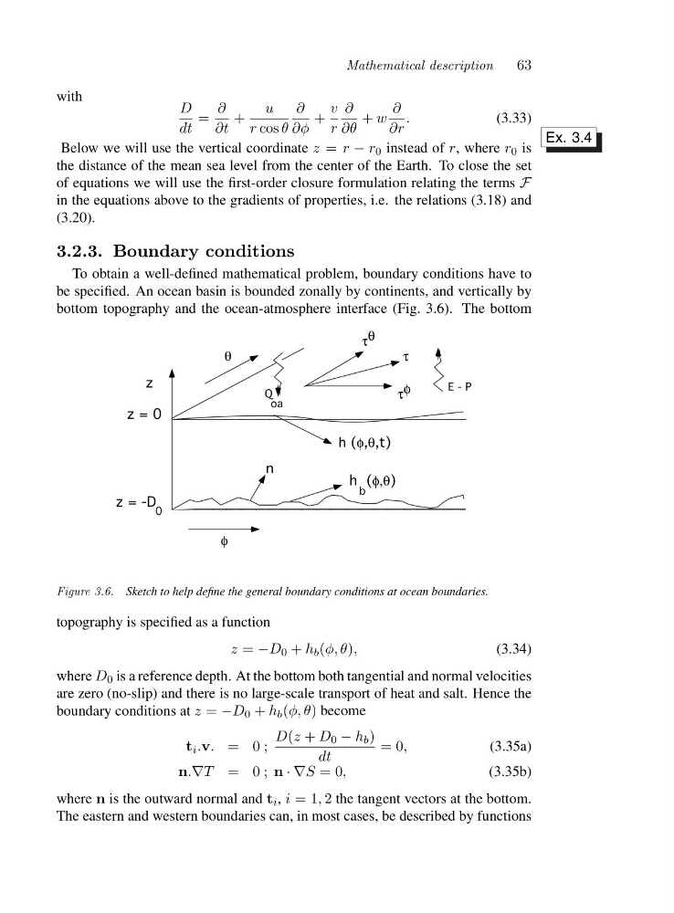
bottom topography and the ocean-atmosphere interface (Fig. 3.6). The bottom
z
z = 0
z = -D
h (φ,θ)
h (φ,θ,t)
φ
θ
τ
τ
θ
φ
τ
E - P
Q
oa
n
b
0
Figure 3.6. Sketch to help define the general boundary conditions at ocean boundaries.
topography is specified as a function
z = −D 0 + h b (φ, θ),
(3.34)
where D 0 is a reference depth. At the bottom both tangential and normal velocities
are zero (no-slip) and there is no large-scale transport of heat and salt. Hence the
boundary conditions at z = −D 0 + h b (φ, θ) become
t i .v. =0 ;
D(z + D 0 − h b )
dt
=0,
(3.35a)
n.∇T =0 ; n ·∇S =0,
(3.35b)
where n is the outward normal and t i , i =1 , 2 the tangent vectors at the bottom.
The eastern and western boundaries can, in most cases, be described by functions
63
with
D
dt
=
∂
∂t
+
u
r cos θ
∂
∂φ
+
v
r
∂
∂θ
+ w
∂
∂r
.
(3.33)
Below we will use the vertical coordinate z = r − r 0 instead of r, where r 0 is
Ex. 3.4
the distance of the mean sea level from the center of the Earth. To close the set
of equations we will use the first-order closure formulation relating the terms F
in the equations above to the gradients of properties, i.e. the relations (3.18) and
(3.20).
3.2.3. Boundary conditions
To obtain a well-defined mathematical problem, boundary conditions have to
be specified. An ocean basin is bounded zonally by continents, and vertically by
bottom topography and the ocean-atmosphere interface (Fig. 3.6). The bottom
z
z = 0
z = -D
h (φ,θ)
h (φ,θ,t)
φ
θ
τ
τ
θ
φ
τ
E - P
Q
oa
n
b
0
Figure 3.6. Sketch to help define the general boundary conditions at ocean boundaries.
topography is specified as a function
z = −D 0 + h b (φ, θ),
(3.34)
where D 0 is a reference depth. At the bottom both tangential and normal velocities
are zero (no-slip) and there is no large-scale transport of heat and salt. Hence the
boundary conditions at z = −D 0 + h b (φ, θ) become
t i .v. =0 ;
D(z + D 0 − h b )
dt
=0,
(3.35a)
n.∇T =0 ; n ·∇S =0,
(3.35b)
where n is the outward normal and t i , i =1 , 2 the tangent vectors at the bottom.
The eastern and western boundaries can, in most cases, be described by functions