

Ice Drift Features in the Zonal and Circular Drift of Sea Ice
Images of MYD09Q1 with a 250-m resolution in an 8-day gridded level provided
by Google Earth Engine (https://explorer.earthengine.google.com/#workspace) are
used to consider selected features of the ice drift in the Fram Strait, near the east
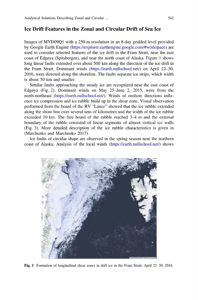
coast of Edgøya (Spitsbergen), and near the north coast of Alaska. Figure 1 shows
long linear faults extended over about 500 km along the direction of the ice drift in
the Fram Strait. Dominant winds (https://earth.nullschool.net/) on April 22–30,
2016, were directed along the shoreline. The faults separate ice strips, which width
is about 50 km and smaller.
Similar faults approaching the steady ice are recognized near the east coast of
Edgøya (Fig. 2). Dominant winds on May 25–June 2, 2015, were from the
north-northeast (https://earth.nullschool.net/). Winds of onshore directions influence ice compression and ice rubble build up in the shear zone. Visual observation
performed from the board of the RV “Lance” showed that the ice rubble extended
along the shore line over several tens of kilometres and the width of the ice rubble
exceeded 10 km. The free board of the rubble reached 3–4 m and the external
boundary of the rubble consisted of linear segments of almost vertical ice walls
(Fig. 3). More detailed description of the ice rubble characteristics is given in
(Marchenko and Marchenko 2017).
Ice faults of circular shape are observed in the spring season near the northern
coast of Alaska. Analysis of the local winds (https://earth.nullschool.net/) shows
Fig. 1 Formation of longitudinal shear zones in drift ice in the Fram Strait; April 22–30, 2016
Analytical Solutions Describing Zonal and Circular …
541
Images of MYD09Q1 with a 250-m resolution in an 8-day gridded level provided
by Google Earth Engine (https://explorer.earthengine.google.com/#workspace) are
used to consider selected features of the ice drift in the Fram Strait, near the east
coast of Edgøya (Spitsbergen), and near the north coast of Alaska. Figure 1 shows
long linear faults extended over about 500 km along the direction of the ice drift in
the Fram Strait. Dominant winds (https://earth.nullschool.net/) on April 22–30,
2016, were directed along the shoreline. The faults separate ice strips, which width
is about 50 km and smaller.
Similar faults approaching the steady ice are recognized near the east coast of
Edgøya (Fig. 2). Dominant winds on May 25–June 2, 2015, were from the
north-northeast (https://earth.nullschool.net/). Winds of onshore directions influence ice compression and ice rubble build up in the shear zone. Visual observation
performed from the board of the RV “Lance” showed that the ice rubble extended
along the shore line over several tens of kilometres and the width of the ice rubble
exceeded 10 km. The free board of the rubble reached 3–4 m and the external
boundary of the rubble consisted of linear segments of almost vertical ice walls
(Fig. 3). More detailed description of the ice rubble characteristics is given in
(Marchenko and Marchenko 2017).
Ice faults of circular shape are observed in the spring season near the northern
coast of Alaska. Analysis of the local winds (https://earth.nullschool.net/) shows
Fig. 1 Formation of longitudinal shear zones in drift ice in the Fram Strait; April 22–30, 2016
Analytical Solutions Describing Zonal and Circular …
541