

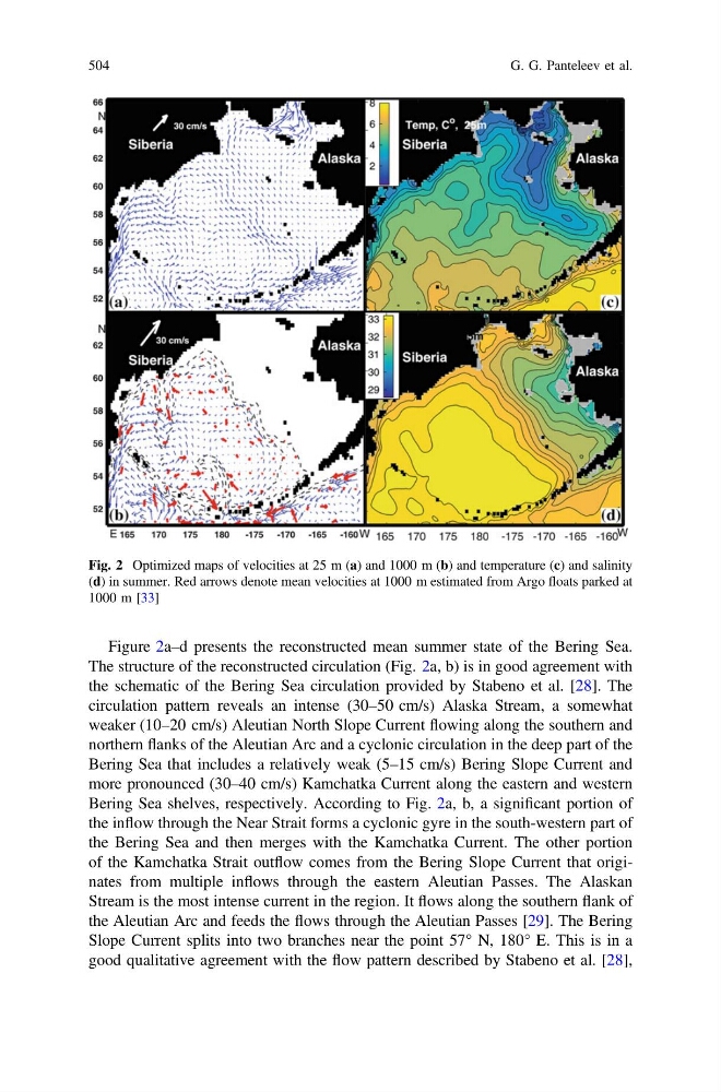
Figure 2a–d presents the reconstructed mean summer state of the Bering Sea.
The structure of the reconstructed circulation (Fig. 2a, b) is in good agreement with
the schematic of the Bering Sea circulation provided by Stabeno et al. [28]. The
circulation pattern reveals an intense (30–50 cm/s) Alaska Stream, a somewhat
weaker (10–20 cm/s) Aleutian North Slope Current flowing along the southern and
northern flanks of the Aleutian Arc and a cyclonic circulation in the deep part of the
Bering Sea that includes a relatively weak (5–15 cm/s) Bering Slope Current and
more pronounced (30–40 cm/s) Kamchatka Current along the eastern and western
Bering Sea shelves, respectively. According to Fig. 2a, b, a significant portion of
the inflow through the Near Strait forms a cyclonic gyre in the south-western part of
the Bering Sea and then merges with the Kamchatka Current. The other portion
of the Kamchatka Strait outflow comes from the Bering Slope Current that originates from multiple inflows through the eastern Aleutian Passes. The Alaskan
Stream is the most intense current in the region. It flows along the southern flank of
the Aleutian Arc and feeds the flows through the Aleutian Passes [29]. The Bering
Slope Current splits into two branches near the point 57° N, 180° E. This is in a
good qualitative agreement with the flow pattern described by Stabeno et al. [28],
Fig. 2 Optimized maps of velocities at 25 m (a) and 1000 m (b) and temperature (c) and salinity
(d) in summer. Red arrows denote mean velocities at 1000 m estimated from Argo floats parked at
1000 m [33]
504
G. G. Panteleev et al.
The structure of the reconstructed circulation (Fig. 2a, b) is in good agreement with
the schematic of the Bering Sea circulation provided by Stabeno et al. [28]. The
circulation pattern reveals an intense (30–50 cm/s) Alaska Stream, a somewhat
weaker (10–20 cm/s) Aleutian North Slope Current flowing along the southern and
northern flanks of the Aleutian Arc and a cyclonic circulation in the deep part of the
Bering Sea that includes a relatively weak (5–15 cm/s) Bering Slope Current and
more pronounced (30–40 cm/s) Kamchatka Current along the eastern and western
Bering Sea shelves, respectively. According to Fig. 2a, b, a significant portion of
the inflow through the Near Strait forms a cyclonic gyre in the south-western part of
the Bering Sea and then merges with the Kamchatka Current. The other portion
of the Kamchatka Strait outflow comes from the Bering Slope Current that originates from multiple inflows through the eastern Aleutian Passes. The Alaskan
Stream is the most intense current in the region. It flows along the southern flank of
the Aleutian Arc and feeds the flows through the Aleutian Passes [29]. The Bering
Slope Current splits into two branches near the point 57° N, 180° E. This is in a
good qualitative agreement with the flow pattern described by Stabeno et al. [28],
Fig. 2 Optimized maps of velocities at 25 m (a) and 1000 m (b) and temperature (c) and salinity
(d) in summer. Red arrows denote mean velocities at 1000 m estimated from Argo floats parked at
1000 m [33]
504
G. G. Panteleev et al.