

The moorings deployed in 1998 from the Russian R/V “Vityaz” close to the
Strait of Gibraltar were organized in several clusters. The goal of the experiment
was to study the formation of the Mediterranean lenses of the saline water flowing
from the strait as the lower current. The horizontal scales of the clusters were
selected to analyze the Mediterranean intrathermocline lenses (Meddies). These
scales are close to the scales of internal tides, thus these measurements allowed us
to estimate the amplitude, wavelength, and direction of the internal tides. The
amplitudes were within 30–40 m. On a mooring cluster (33° N, 11° W), in which
the moorings operated synchronously for 15 days, it was possible to estimate the
direction and wavelength of the semidiurnal internal tides. We expected that the
waves would propagate from the continental slope in the region of Morocco, but the
wave arrived in the direction to the south-southwest (200) from the southwestern
coast of the Iberian Peninsula. The wavelength was 100 km (Fig. 4).
The moored measurements in 1984–1985 in the middle of the Iberian Basin (41°
30′ N, 15° 00′ W) at depths of 2600–2700 m on five moorings over the ocean
depths of 5300–5500 m resulted in the mean amplitude of the semidiurnal internal
tide equal to 30–40 m, while at a depth of 1500–1600 m the amplitudes were 40–
50 m.
The spatiotemporal spectrum based on the data at 2600 m using the Barber’s
method [13] is shown in Fig. 5. The wavelength of the semidiurnal internal tides
was estimated at 105 km. The waves propagated from the northeast from a region
of shallower depths less than 850 m. A bank exists here at 42° 30′ N, 12° 00′ W.
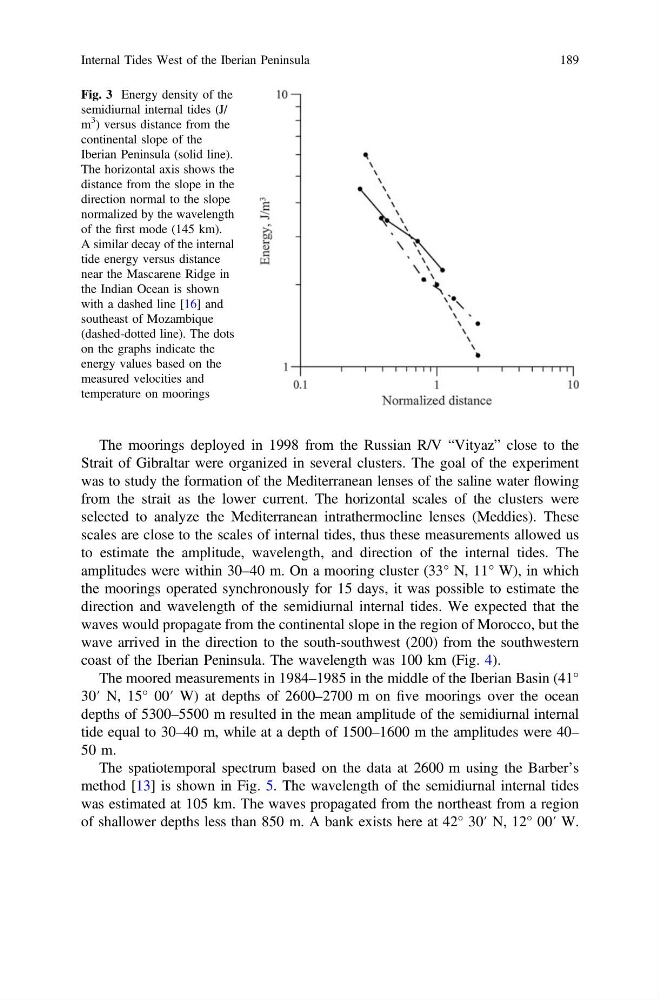
Fig. 3 Energy density of the
semidiurnal internal tides (J/
m
3
) versus distance from the
continental slope of the
Iberian Peninsula (solid line).
The horizontal axis shows the
distance from the slope in the
direction normal to the slope
normalized by the wavelength
of the first mode (145 km).
A similar decay of the internal
tide energy versus distance
near the Mascarene Ridge in
the Indian Ocean is shown
with a dashed line [16] and
southeast of Mozambique
(dashed-dotted line). The dots
on the graphs indicate the
energy values based on the
measured velocities and
temperature on moorings
Internal Tides West of the Iberian Peninsula
189
Strait of Gibraltar were organized in several clusters. The goal of the experiment
was to study the formation of the Mediterranean lenses of the saline water flowing
from the strait as the lower current. The horizontal scales of the clusters were
selected to analyze the Mediterranean intrathermocline lenses (Meddies). These
scales are close to the scales of internal tides, thus these measurements allowed us
to estimate the amplitude, wavelength, and direction of the internal tides. The
amplitudes were within 30–40 m. On a mooring cluster (33° N, 11° W), in which
the moorings operated synchronously for 15 days, it was possible to estimate the
direction and wavelength of the semidiurnal internal tides. We expected that the
waves would propagate from the continental slope in the region of Morocco, but the
wave arrived in the direction to the south-southwest (200) from the southwestern
coast of the Iberian Peninsula. The wavelength was 100 km (Fig. 4).
The moored measurements in 1984–1985 in the middle of the Iberian Basin (41°
30′ N, 15° 00′ W) at depths of 2600–2700 m on five moorings over the ocean
depths of 5300–5500 m resulted in the mean amplitude of the semidiurnal internal
tide equal to 30–40 m, while at a depth of 1500–1600 m the amplitudes were 40–
50 m.
The spatiotemporal spectrum based on the data at 2600 m using the Barber’s
method [13] is shown in Fig. 5. The wavelength of the semidiurnal internal tides
was estimated at 105 km. The waves propagated from the northeast from a region
of shallower depths less than 850 m. A bank exists here at 42° 30′ N, 12° 00′ W.
Fig. 3 Energy density of the
semidiurnal internal tides (J/
m
3
) versus distance from the
continental slope of the
Iberian Peninsula (solid line).
The horizontal axis shows the
distance from the slope in the
direction normal to the slope
normalized by the wavelength
of the first mode (145 km).
A similar decay of the internal
tide energy versus distance
near the Mascarene Ridge in
the Indian Ocean is shown
with a dashed line [16] and
southeast of Mozambique
(dashed-dotted line). The dots
on the graphs indicate the
energy values based on the
measured velocities and
temperature on moorings
Internal Tides West of the Iberian Peninsula
189