

A Multivariate Reduced-order Optimal Interpolation Method and its Application
297
Matrix L coefficients
Explained variance
(J1jI
(JŢ
(Js
(%)
(Sv)
(OC)
(Psu)
Basin-wide
58.5
1.885 0.611 0.122
WestemMed.
62.4
1.966 0.451 0.099
Algerian Current
70.5
3.612 0.856 0.250
Ionian
44.2
1.300 0.746 0.067
Levantine
43.5
1.049 0.516 0.081
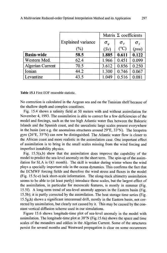
Table 15.1 First EOF ensemble statistic.
No correction is calculated in the Aegean sea and on the Tunisian shelfbecause of
the shallow depth and complex coastlines.
Fig. 15.4 shows a salinity field at 50 meters with and without assimilation for
November 4, 1993. The assimilation is able to correct for a few deficiencies ofthe
model and forcings, such as the too high Atlantic water flux between the Balearic
Islands and the Spanish coast, and the unrealistic large scales present everywhere
in the basin (see e.g. the anomalous structures around 29°E, 33°N). The Ierapetra
gyre (26°E, 35°N) can now be distinguished. The Atlantic water flow is closer to
the African coast and more realistic in the assimilation case. One important effect
of assimilation is to bring in the small scales missing from the wind forcing and
imperfect instability physics.
Fig. 15.5(a,b) show that the assimilation does improve the capability of the
model to predict the sea-level anomaly on the short term. The spin-up ofthe assimilation for SLA is 0(1 month). The skill is weaker during winter where the wind
plays a specially important role in the ocean dynamics. This confirms the fact that
the ECMWF forcing fields and therefore the wind stress and fluxes in the model
(Fig. 15.5c-e) lack short-scale information. The along-track altimetry assimilation
seems to be able to (at least partly) introduce those scales, but the largest effect of
the assimilation, in particular for mesoscale features, is mostly in summer (Fig.
15.51). A long-term trend of sea-level anomaly appears in the Eastem basin (Fig.
15 .5b); it is partly corrected by the assimilation. The heat storage time series (Fig.
15.5g,h) shows a significant interannual drift, mostly in the Eastem basin, not corrected by assimilation, but clearly not caused by it. This may be caused by the constant vertical diffusion scheme used in our simulations.
Figure 15.6 shows longitude-time plot of sea-level anomaly in the model with
assimilation. The longitude-time plot at 38°N (Fig.15.6a) shows the space and time
scales of the meanders and eddies in the Algerian Current. Some of the structures
persist for several months and Westward propagation is clear on some occurences
297
Matrix L coefficients
Explained variance
(J1jI
(JŢ
(Js
(%)
(Sv)
(OC)
(Psu)
Basin-wide
58.5
1.885 0.611 0.122
WestemMed.
62.4
1.966 0.451 0.099
Algerian Current
70.5
3.612 0.856 0.250
Ionian
44.2
1.300 0.746 0.067
Levantine
43.5
1.049 0.516 0.081
Table 15.1 First EOF ensemble statistic.
No correction is calculated in the Aegean sea and on the Tunisian shelfbecause of
the shallow depth and complex coastlines.
Fig. 15.4 shows a salinity field at 50 meters with and without assimilation for
November 4, 1993. The assimilation is able to correct for a few deficiencies ofthe
model and forcings, such as the too high Atlantic water flux between the Balearic
Islands and the Spanish coast, and the unrealistic large scales present everywhere
in the basin (see e.g. the anomalous structures around 29°E, 33°N). The Ierapetra
gyre (26°E, 35°N) can now be distinguished. The Atlantic water flow is closer to
the African coast and more realistic in the assimilation case. One important effect
of assimilation is to bring in the small scales missing from the wind forcing and
imperfect instability physics.
Fig. 15.5(a,b) show that the assimilation does improve the capability of the
model to predict the sea-level anomaly on the short term. The spin-up ofthe assimilation for SLA is 0(1 month). The skill is weaker during winter where the wind
plays a specially important role in the ocean dynamics. This confirms the fact that
the ECMWF forcing fields and therefore the wind stress and fluxes in the model
(Fig. 15.5c-e) lack short-scale information. The along-track altimetry assimilation
seems to be able to (at least partly) introduce those scales, but the largest effect of
the assimilation, in particular for mesoscale features, is mostly in summer (Fig.
15.51). A long-term trend of sea-level anomaly appears in the Eastem basin (Fig.
15 .5b); it is partly corrected by the assimilation. The heat storage time series (Fig.
15.5g,h) shows a significant interannual drift, mostly in the Eastem basin, not corrected by assimilation, but clearly not caused by it. This may be caused by the constant vertical diffusion scheme used in our simulations.
Figure 15.6 shows longitude-time plot of sea-level anomaly in the model with
assimilation. The longitude-time plot at 38°N (Fig.15.6a) shows the space and time
scales of the meanders and eddies in the Algerian Current. Some of the structures
persist for several months and Westward propagation is clear on some occurences