

Forecasting of Sea-level, Currents and Sea Ice in the Baltic Sea
237
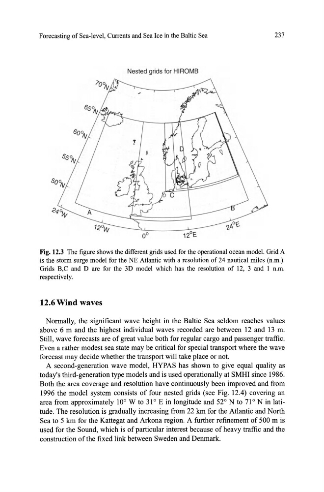
Nested grids for HIROMB
Fig. 12.3 The figure shows the different grids used for the operational ocean model. Grid A
is the storm surge model for the NE Atlantic with a resolution of 24 nautical miles (n.m.).
Grids B,C and D are for the 3D model which has the resolution of 12, 3 and 1 n.m.
respectively.
12.6 Wind waves
Normally, the significant wave height in the Baltic Sea seldom reaches values
above 6 m and the highest individual waves recorded are between 12 and 13 m.
Still, wave forecasts are of great value both for regular cargo and passenger traffic.
Even a rather modest sea state may be critic al for special transport where the wave
forecast may decide whether the transport will take place or not.
A second-generation wave model, HYPAS has shown to give equal quality as
today's third-generation type models and is used operationally at SMHI since 1986.
Both the area coverage and resolution have continuously been improved and from
1996 the model system consists of four nested grids (see Fig. 12.4) covering an
area from approximately 10 0 W to 31 0 E in longitude and 52 0 N to 71 0 N in latitude. The resolution is gradually increasing from 22 lan for the Atlantic and North
Sea to 5 lan for the Kattegat and Arkona region. A further refinement of 500 m is
used for the Sound, which is of particular interest because of heavy traffic and the
construction of the fixed link between Sweden and Denmark.
237
Nested grids for HIROMB
Fig. 12.3 The figure shows the different grids used for the operational ocean model. Grid A
is the storm surge model for the NE Atlantic with a resolution of 24 nautical miles (n.m.).
Grids B,C and D are for the 3D model which has the resolution of 12, 3 and 1 n.m.
respectively.
12.6 Wind waves
Normally, the significant wave height in the Baltic Sea seldom reaches values
above 6 m and the highest individual waves recorded are between 12 and 13 m.
Still, wave forecasts are of great value both for regular cargo and passenger traffic.
Even a rather modest sea state may be critic al for special transport where the wave
forecast may decide whether the transport will take place or not.
A second-generation wave model, HYPAS has shown to give equal quality as
today's third-generation type models and is used operationally at SMHI since 1986.
Both the area coverage and resolution have continuously been improved and from
1996 the model system consists of four nested grids (see Fig. 12.4) covering an
area from approximately 10 0 W to 31 0 E in longitude and 52 0 N to 71 0 N in latitude. The resolution is gradually increasing from 22 lan for the Atlantic and North
Sea to 5 lan for the Kattegat and Arkona region. A further refinement of 500 m is
used for the Sound, which is of particular interest because of heavy traffic and the
construction of the fixed link between Sweden and Denmark.