

Assimilation of Satellite Altimetry in Ocean Models
125
g
.. c 2
2.0
]! 1.5
e
a
(;
~
~ 1.0
'"
~
~ 0.5
a:
Surface 1000 m
.. .
" ~.
'; ...•.... ~.
.... , .....•.. J" ..... ; .... ..j ...
O.O....,..-----,-L--"---'-y-<---"---"-,--o
50
100
150
Days 'rom 1 sI January
g
. .
c
2
2.0
]! 1.5
e
a
(;
c
o
] 1.0
' "
. .
'"
e
"
~ 0.5
a:
Below 1000m
O.O. . . . , . . - - - - - , - - -r---'--,--- -
o
50
100
150
Oays 'rom 1 sI January
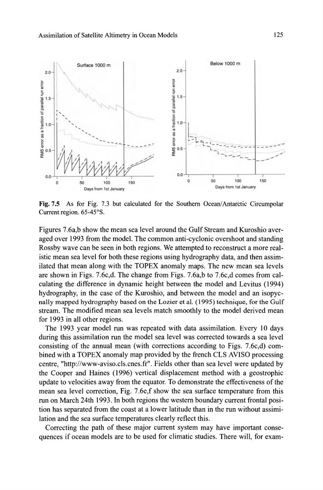
Fig.7.5 As for Fig. 7.3 but calculated for the Southem Ocean/Antarctic Circumpolar
Current region. 65-45°S.
Figures 7.6a,b show the mean sea level around the GulfStream and Kuroshio averaged over 1993 from the model. The common anti-cyclonic overshoot and standing
Rossby wave can be seen in both regions. We attempted to reconstruct a more realistic mean sea level for both these regions using hydrography data, and then assimilated that mean along with the TOPEX anomaly maps. The new mean sea levels
are shown in Figs. 7.6c,d. The change from Figs. 7.6a,b to 7.6c,d comes from calculating the difference in dynamic height between the model and Levitus (1994)
hydrography, in the case of the Kuroshio, and between the model and an isopycnally mapped hydrography based on the Lozier et al. (1995) technique, for the Gulf
stream. The modified mean sea levels match smoothly to the model derived mean
for 1993 in all other regions.
The 1993 year model run was repeated with data assimilation. Every 10 days
during this assimilation run the model sea level was corrected towards asea level
con si sting of the annual mean (with corrections according to Figs. 7.6c,d) combined with a TOPEX anomaly map provided by the french CLS AVISO processing
centre, .. http://www-aviso.cls.cnes.fr ... Fields other than sea level were updated by
the Cooper and Haines (1996) vertical displacement method with a geostrophic
update to velocities away from the equator. To demonstrate the effectiveness of the
mean sea level correction, Fig. 7.6e,f show the sea surface temperature from this
run on March 24th 1993. In both regions the westem boundary current frontal position has separated from the coast at a lower latitude than in the run without assimilation and the sea surface temperatures clearly reflect this.
Correcting the path of these major current system may have important consequences if ocean models are to be used for climatic studies. There will, for exam-
125
g
.. c 2
2.0
]! 1.5
e
a
(;
~
~ 1.0
'"
~
~ 0.5
a:
Surface 1000 m
.. .
" ~.
'; ...•.... ~.
.... , .....•.. J" ..... ; .... ..j ...
O.O....,..-----,-L--"---'-y-<---"---"-,--o
50
100
150
Days 'rom 1 sI January
g
. .
c
2
2.0
]! 1.5
e
a
(;
c
o
] 1.0
' "
. .
'"
e
"
~ 0.5
a:
Below 1000m
O.O. . . . , . . - - - - - , - - -r---'--,--- -
o
50
100
150
Oays 'rom 1 sI January
Fig.7.5 As for Fig. 7.3 but calculated for the Southem Ocean/Antarctic Circumpolar
Current region. 65-45°S.
Figures 7.6a,b show the mean sea level around the GulfStream and Kuroshio averaged over 1993 from the model. The common anti-cyclonic overshoot and standing
Rossby wave can be seen in both regions. We attempted to reconstruct a more realistic mean sea level for both these regions using hydrography data, and then assimilated that mean along with the TOPEX anomaly maps. The new mean sea levels
are shown in Figs. 7.6c,d. The change from Figs. 7.6a,b to 7.6c,d comes from calculating the difference in dynamic height between the model and Levitus (1994)
hydrography, in the case of the Kuroshio, and between the model and an isopycnally mapped hydrography based on the Lozier et al. (1995) technique, for the Gulf
stream. The modified mean sea levels match smoothly to the model derived mean
for 1993 in all other regions.
The 1993 year model run was repeated with data assimilation. Every 10 days
during this assimilation run the model sea level was corrected towards asea level
con si sting of the annual mean (with corrections according to Figs. 7.6c,d) combined with a TOPEX anomaly map provided by the french CLS AVISO processing
centre, .. http://www-aviso.cls.cnes.fr ... Fields other than sea level were updated by
the Cooper and Haines (1996) vertical displacement method with a geostrophic
update to velocities away from the equator. To demonstrate the effectiveness of the
mean sea level correction, Fig. 7.6e,f show the sea surface temperature from this
run on March 24th 1993. In both regions the westem boundary current frontal position has separated from the coast at a lower latitude than in the run without assimilation and the sea surface temperatures clearly reflect this.
Correcting the path of these major current system may have important consequences if ocean models are to be used for climatic studies. There will, for exam-