

72
Hale and Pflaumann
Regional Setting
Two of the cores under study, GeoB 1309-2 and
GeoB 1312-2, were taken from the Rio Grande
Rise during METEOR cruise M15/2 (patzold et al.
1993) at water depths ofJ,963 meters and 3,436
meters, respectively (Fig. 1). This submarine pl~teau of volcanic hot-spot origin (Morgan 1972) IS
located at about 30° S, separating the Argentine
Basin to the south and the Brazil Basin to the north,
and bounded by the relatively steep, narrow Vema
Channel to the west and the broader, less well defined Hunter Channel to the east (Patzold et al.
1996). Sedimentation rates in these two cores, determined from oxygen isotope curves, were consistently low (~ I em per 1,000 years or less). The
Rio Grande Rise area is not directly influenced by
the major surface currents of the South Atlantic
Gyre, being located slightly west of the gyre center.
It is bounded by the South Equatorial Current
(SEC) to the north, the Brazil Current (BC) to the
west and the South Atlantic Current (SAC) to the
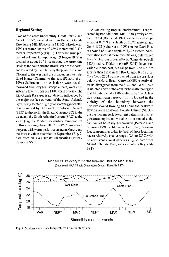
south (Fig. 1). Modem sea-surface temperatures
in this area range from 18.5° to 24° C throughout
the year, with warm peaks occurring in Marc~, and
the lowest values recorded in September (Fig. 2,
data from NOAA Climate Diagnostics CenterReynolds SST).
A contrasting tropical environment is represented by two additional METEOR gravity cores,
GeoB 2204 (Bleil et al. 1994) on the Brazil Slope
at about 8.5° S at a depth of 2,072 meters, and
GeoB 1523 (Schulz et al. 1991) on the CeaniRise
at about 3.8° N at a depth of3,292 meters. Sedimentation rates at these two stations, determined
from 8 18 0 curves provided by R. Schneider (GeoB
1523) and A. Diirkoop (GeoB 2204), have been
variable in the past, but range from 2 to 4 times
greater than those in the Rio Grande Rise cores.
Core GeoB 2204 was recovered from the sea floor
below the North Brazil Current (NBC) shortly after its divergence from the SEC, and GeoB 1523
is situated north of the equator beneath tlle region
that McIntyre et al. (1989) refer to as "the Atlantic's warm water reservoir". It is located in the
vicinity of the boundary between the
northwestward flowing SEC and the eastward
flowing South Equatorial Counter Current (SECC),
but the modem surface current patterns in this region are complex and variable on an annual scale,
and cannot be easily generalized (Peterson and
Stramma 1991; Riihlemann et al. 1996). Sea-surface temperatures today for both of these locations
have a relatively smaller range of 26° to 28° C, with
no consistent annual patterns (Fig. 2, data from
NOAA Climate Diagnostics Center - Reynolds
SST).
Modern SSTs every 2 months from Jan. 1990 to Mar. 1993
(Data from NOAA Climate Diagnostics Center - Reynolds SST)
0 28
0)
26
Q)
"0
- Q) 24
.....
:::J
22
- ~
Q)
20
a.
E
Q)
18
IIVIAR
SEPT
IVIAR
Bimonthly measurements
Fig. 2. Modem sea-surface temperatures from the study area.
Hale and Pflaumann
Regional Setting
Two of the cores under study, GeoB 1309-2 and
GeoB 1312-2, were taken from the Rio Grande
Rise during METEOR cruise M15/2 (patzold et al.
1993) at water depths ofJ,963 meters and 3,436
meters, respectively (Fig. 1). This submarine pl~teau of volcanic hot-spot origin (Morgan 1972) IS
located at about 30° S, separating the Argentine
Basin to the south and the Brazil Basin to the north,
and bounded by the relatively steep, narrow Vema
Channel to the west and the broader, less well defined Hunter Channel to the east (Patzold et al.
1996). Sedimentation rates in these two cores, determined from oxygen isotope curves, were consistently low (~ I em per 1,000 years or less). The
Rio Grande Rise area is not directly influenced by
the major surface currents of the South Atlantic
Gyre, being located slightly west of the gyre center.
It is bounded by the South Equatorial Current
(SEC) to the north, the Brazil Current (BC) to the
west and the South Atlantic Current (SAC) to the
south (Fig. 1). Modem sea-surface temperatures
in this area range from 18.5° to 24° C throughout
the year, with warm peaks occurring in Marc~, and
the lowest values recorded in September (Fig. 2,
data from NOAA Climate Diagnostics CenterReynolds SST).
A contrasting tropical environment is represented by two additional METEOR gravity cores,
GeoB 2204 (Bleil et al. 1994) on the Brazil Slope
at about 8.5° S at a depth of 2,072 meters, and
GeoB 1523 (Schulz et al. 1991) on the CeaniRise
at about 3.8° N at a depth of3,292 meters. Sedimentation rates at these two stations, determined
from 8 18 0 curves provided by R. Schneider (GeoB
1523) and A. Diirkoop (GeoB 2204), have been
variable in the past, but range from 2 to 4 times
greater than those in the Rio Grande Rise cores.
Core GeoB 2204 was recovered from the sea floor
below the North Brazil Current (NBC) shortly after its divergence from the SEC, and GeoB 1523
is situated north of the equator beneath tlle region
that McIntyre et al. (1989) refer to as "the Atlantic's warm water reservoir". It is located in the
vicinity of the boundary between the
northwestward flowing SEC and the eastward
flowing South Equatorial Counter Current (SECC),
but the modem surface current patterns in this region are complex and variable on an annual scale,
and cannot be easily generalized (Peterson and
Stramma 1991; Riihlemann et al. 1996). Sea-surface temperatures today for both of these locations
have a relatively smaller range of 26° to 28° C, with
no consistent annual patterns (Fig. 2, data from
NOAA Climate Diagnostics Center - Reynolds
SST).
Modern SSTs every 2 months from Jan. 1990 to Mar. 1993
(Data from NOAA Climate Diagnostics Center - Reynolds SST)
0 28
0)
26
Q)
"0
- Q) 24
.....
:::J
22
- ~
Q)
20
a.
E
Q)
18
IIVIAR
SEPT
IVIAR
Bimonthly measurements
Fig. 2. Modem sea-surface temperatures from the study area.