

306
Diekmann et al.
-70·
-60·
-50'
-40·
-30'
-20'
Vema
Channel
Argentine
Basin
Brazil
Basin
-10·
O·
Angola
Basin
10·
20'
30'
Cape
Basin
- ..................
Agulhas
Basin
40'
-20·
-30·
-4 0·
-50'
"'" Falkland
Antarctic
Plateau .....
Circumpolar
Current
SW Indian
Ridge
Scotia Sea
-60'
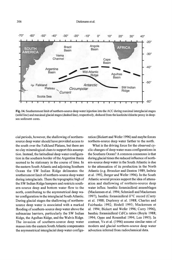
Fig. 14. Southernmost limit of northern-source deep water injection into the ACe during maximal interglacial stages
(solid line) and maximal glacial stages (dashed line), respectively, deduced from the kaolinite/chlorite proxy in deepsea sediment cores.
cial periods, however, the shallowing of northernsource deep water should have provided access to
the south over the Falkland Plataeu, but there are
no clay mineralogical clues to support this assumption. Instead, the latitudinal deep water configuration in the southern border of the Argentine Basin
seemed to be stationary in the course of time. In
the eastern South Atlantic and adjoining Southern
Ocean the SW Indian Ridge delineates the
southernmost limit of northern-source deep water
during interglacials. There the topographic high of
the SW Indian Ridge hampers and restricts southern-source deep and bottom water flow to the
north, contributing to the asymmetrical deep water configuration in the interglacial South Atlantic.
During glacial stages the shallowing of northernsource deep water is associated with a marked
flooding of southern-source deep water above the
submarine barriers, particularly the SW Indian
Ridge, the Agulhas Ridge, and the Walvis Ridge.
The invasion of southern-source deep water
masses into the eastern South Atlantic compensates
the asymmetrical interglacial deep water configuration (Bickert and Wefer 1996) and maybe forces
northern-source deep water farther to the north.
What is the driving force for the observed cyclic changes of deep water mass configurations in
the Southern Ocean? A common consensus is that
during glacial times the reduced influence of northern-source deep water in the South Atlantic is due
to the attenuation of its production in the North
Atlantic (e.g. Broecker and Denton 1989, Imbrie
et aJ. 1992, Berger and Wefer 1996). In the South
Atlantic several proxies support the idea of attenuation and shallowing of northern-source deep
water influx: benthic foraminiferal assemblages
(Mackensen et aJ. 1994; Schmiedl and Mackensen
1997), benthic foraminiferal 013C record (Curry
et aJ. 1988; Duplessy et al. 1988; Charles and
Fairbanks 1992; Hodell 1993 ; Mackensen et
aJ. 1994; Bickert and Wefer 1996; Curry 1996),
benthic foraminiferal Cd/Ca ratios (Boyle 1988;
1994; Oppo and Rosenthal 1994; Lea 1995). In
contrast, Yu et aJ. (1996) assume similar rates of
modern and glacial northern-source deep water
advection inferred from radiochemical data.
Diekmann et al.
-70·
-60·
-50'
-40·
-30'
-20'
Vema
Channel
Argentine
Basin
Brazil
Basin
-10·
O·
Angola
Basin
10·
20'
30'
Cape
Basin
- ..................
Agulhas
Basin
40'
-20·
-30·
-4 0·
-50'
"'" Falkland
Antarctic
Plateau .....
Circumpolar
Current
SW Indian
Ridge
Scotia Sea
-60'
Fig. 14. Southernmost limit of northern-source deep water injection into the ACe during maximal interglacial stages
(solid line) and maximal glacial stages (dashed line), respectively, deduced from the kaolinite/chlorite proxy in deepsea sediment cores.
cial periods, however, the shallowing of northernsource deep water should have provided access to
the south over the Falkland Plataeu, but there are
no clay mineralogical clues to support this assumption. Instead, the latitudinal deep water configuration in the southern border of the Argentine Basin
seemed to be stationary in the course of time. In
the eastern South Atlantic and adjoining Southern
Ocean the SW Indian Ridge delineates the
southernmost limit of northern-source deep water
during interglacials. There the topographic high of
the SW Indian Ridge hampers and restricts southern-source deep and bottom water flow to the
north, contributing to the asymmetrical deep water configuration in the interglacial South Atlantic.
During glacial stages the shallowing of northernsource deep water is associated with a marked
flooding of southern-source deep water above the
submarine barriers, particularly the SW Indian
Ridge, the Agulhas Ridge, and the Walvis Ridge.
The invasion of southern-source deep water
masses into the eastern South Atlantic compensates
the asymmetrical interglacial deep water configuration (Bickert and Wefer 1996) and maybe forces
northern-source deep water farther to the north.
What is the driving force for the observed cyclic changes of deep water mass configurations in
the Southern Ocean? A common consensus is that
during glacial times the reduced influence of northern-source deep water in the South Atlantic is due
to the attenuation of its production in the North
Atlantic (e.g. Broecker and Denton 1989, Imbrie
et aJ. 1992, Berger and Wefer 1996). In the South
Atlantic several proxies support the idea of attenuation and shallowing of northern-source deep
water influx: benthic foraminiferal assemblages
(Mackensen et aJ. 1994; Schmiedl and Mackensen
1997), benthic foraminiferal 013C record (Curry
et aJ. 1988; Duplessy et al. 1988; Charles and
Fairbanks 1992; Hodell 1993 ; Mackensen et
aJ. 1994; Bickert and Wefer 1996; Curry 1996),
benthic foraminiferal Cd/Ca ratios (Boyle 1988;
1994; Oppo and Rosenthal 1994; Lea 1995). In
contrast, Yu et aJ. (1996) assume similar rates of
modern and glacial northern-source deep water
advection inferred from radiochemical data.