

288
Diekmann et al.
-70 0
-60 0
_50 0
-40 0
-30·
-20·
-10·
o·
10·
20·
30·
40·
PS2564
)0
SW I NOlAN
RIDGE
0 0
-10·
-20·
-30·
-40·
-50 0
_600
-70·
-75·
-80·
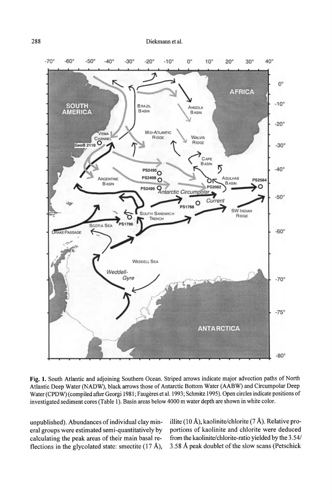
Fig. 1. South Atlantic and adjoining Southern Ocean. Striped arrows indicate major advection paths of North
Atlantic Deep Water (NADW), black arrows those of Antarctic Bottom Water (AABW) and Circumpolar Deep
Water (CPDW) (compiled after Georgi 1981 ; Faugeres et al. 1993; Schmitz 1995). Open circles indicate positions of
investigated sediment cores (Table 1). Basin areas below 4000 m water depth are shown in white color.
unpublished). Abundances of individual clay minerai groups were estimated semi-quantitatively by
calculating the peak areas of their main basal reflections in the glycolated state: smectite (17 A),
illite (lOA), kaolinite/chlorite (7 A). Relative proportions of kaolinite and chlorite were deduced
from the kaolinite/chlorite-ratio yielded by the 3 .54/
3.58 A peak doublet of the slow scans (Petschick
Diekmann et al.
-70 0
-60 0
_50 0
-40 0
-30·
-20·
-10·
o·
10·
20·
30·
40·
PS2564
)0
SW I NOlAN
RIDGE
0 0
-10·
-20·
-30·
-40·
-50 0
_600
-70·
-75·
-80·
Fig. 1. South Atlantic and adjoining Southern Ocean. Striped arrows indicate major advection paths of North
Atlantic Deep Water (NADW), black arrows those of Antarctic Bottom Water (AABW) and Circumpolar Deep
Water (CPDW) (compiled after Georgi 1981 ; Faugeres et al. 1993; Schmitz 1995). Open circles indicate positions of
investigated sediment cores (Table 1). Basin areas below 4000 m water depth are shown in white color.
unpublished). Abundances of individual clay minerai groups were estimated semi-quantitatively by
calculating the peak areas of their main basal reflections in the glycolated state: smectite (17 A),
illite (lOA), kaolinite/chlorite (7 A). Relative proportions of kaolinite and chlorite were deduced
from the kaolinite/chlorite-ratio yielded by the 3 .54/
3.58 A peak doublet of the slow scans (Petschick