

Stable Carbon Isotopes in Benthic Foraminifera
245
I 'I~ 1 3 14 1 5 1
. . .
..!. PI' " I'
8
9 1'0 I "
6
1.5 ...-------- - - - - - - - - - - G- ui:-n- ea --=- Ba - s ..,-i n ---,
0.5
0
m
-0.5
C
ll.
-1
l -1.5
(.J
0
100
200
(')
1.5
... <0
0.5
0
-0.5
-1
-1 .5
0
100
200
age (ka)
cial substage 7.4 reveal that, for the short time interval of only one precessional cycle, the deepwater circulation turned to a glacial mode.
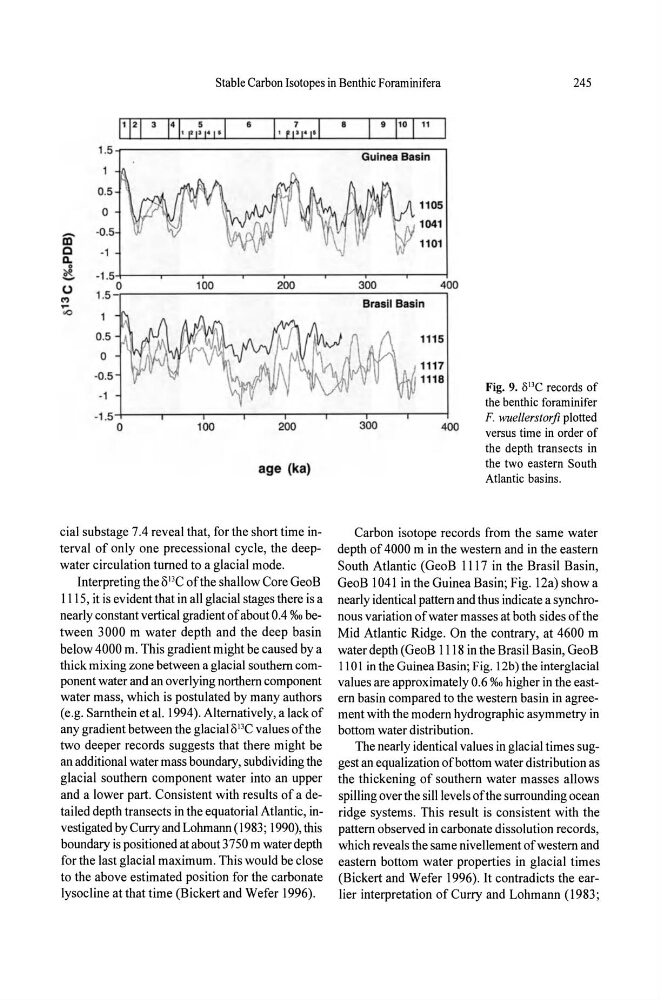
Interpreting the Ol3C of the shallow Core GeoB
1115, it is evident that in all glacial stages there is a
nearly constant vertical gradient of about 0.4 0/00 between 3000 m water depth and the deep basin
below 4000 m. This gradient might be caused by a
thick mixing zone between a glacial southern component water and an overlying northern component
water mass, which is postulated by many authors
(e.g. Sarnthein et al. 1994). Alternatively, a lack of
any gradient between the glacialo 13 C values of the
two deeper records suggests that there might be
an additional water mass boundary, subdividing the
glacial southern component water into an upper
and a lower part. Consistent with results of a detai led depth transects in the equatorial Atlantic, investigated by Curry and Lohmann (1983; 1990), this
boundary is positioned at about 3750 m water depth
for the last glacial maximum . This would be close
to the above estimated position for the carbonate
lysocline at that time (Bickert and Wefer 1996).
1105
1041
1101
300
400
Brasil Basin
111 5
1117
1118
Fig. 9. olle records of
the benthic foraminifer
F. wuellerstorfi plotted
300
400
versus time in order of
the depth transects in
the two eastern South
Atlantic basins.
Carbon isotope records from the same water
depth of 4000 m in the western and in the eastern
South Atlantic (GeoB 1117 in the Brasil Basin,
GeoB 1041 in the Guinea Basin; Fig. 12a) show a
nearly identical pattern and thus indicate a synchronous variation of water masses at both sides of the
Mid Atlantic Ridge. On the contrary, at 4600 m
water depth (GeoB IllS in the Brasil Basin, GeoB
1101 in the Guinea Basin; Fig. 12b) the interglacial
values are approximately 0.6 %0 higher in the eastern basin compared to the western basin in agreement with the modern hydrographic asymmetry in
bottom water distribution.
The nearly identical values in glacial times suggest an equalization of bottom water distribution as
the thickening of southern water masses allows
spilling over the sill levels of the surrounding ocean
ridge systems. This result is consistent with the
pattern observed in carbonate dissolution records,
which reveals the same nivellement of western and
eastern bottom water properties in glacial times
(Bickert and Wefer 1996). It contradicts the earlier interpretation of Curry and Lohmann (1983;
245
I 'I~ 1 3 14 1 5 1
. . .
..!. PI' " I'
8
9 1'0 I "
6
1.5 ...-------- - - - - - - - - - - G- ui:-n- ea --=- Ba - s ..,-i n ---,
0.5
0
m
-0.5
C
ll.
-1
l -1.5
(.J
0
100
200
(')
1.5
... <0
0.5
0
-0.5
-1
-1 .5
0
100
200
age (ka)
cial substage 7.4 reveal that, for the short time interval of only one precessional cycle, the deepwater circulation turned to a glacial mode.
Interpreting the Ol3C of the shallow Core GeoB
1115, it is evident that in all glacial stages there is a
nearly constant vertical gradient of about 0.4 0/00 between 3000 m water depth and the deep basin
below 4000 m. This gradient might be caused by a
thick mixing zone between a glacial southern component water and an overlying northern component
water mass, which is postulated by many authors
(e.g. Sarnthein et al. 1994). Alternatively, a lack of
any gradient between the glacialo 13 C values of the
two deeper records suggests that there might be
an additional water mass boundary, subdividing the
glacial southern component water into an upper
and a lower part. Consistent with results of a detai led depth transects in the equatorial Atlantic, investigated by Curry and Lohmann (1983; 1990), this
boundary is positioned at about 3750 m water depth
for the last glacial maximum . This would be close
to the above estimated position for the carbonate
lysocline at that time (Bickert and Wefer 1996).
1105
1041
1101
300
400
Brasil Basin
111 5
1117
1118
Fig. 9. olle records of
the benthic foraminifer
F. wuellerstorfi plotted
300
400
versus time in order of
the depth transects in
the two eastern South
Atlantic basins.
Carbon isotope records from the same water
depth of 4000 m in the western and in the eastern
South Atlantic (GeoB 1117 in the Brasil Basin,
GeoB 1041 in the Guinea Basin; Fig. 12a) show a
nearly identical pattern and thus indicate a synchronous variation of water masses at both sides of the
Mid Atlantic Ridge. On the contrary, at 4600 m
water depth (GeoB IllS in the Brasil Basin, GeoB
1101 in the Guinea Basin; Fig. 12b) the interglacial
values are approximately 0.6 %0 higher in the eastern basin compared to the western basin in agreement with the modern hydrographic asymmetry in
bottom water distribution.
The nearly identical values in glacial times suggest an equalization of bottom water distribution as
the thickening of southern water masses allows
spilling over the sill levels of the surrounding ocean
ridge systems. This result is consistent with the
pattern observed in carbonate dissolution records,
which reveals the same nivellement of western and
eastern bottom water properties in glacial times
(Bickert and Wefer 1996). It contradicts the earlier interpretation of Curry and Lohmann (1983;