

Part C | 30.1
656 Part C Coastal Design
bility curve and is the modern approach as discussed
below.
Finally, the wave conditions at the structure can
produce wave setup, N
Á which is the time averaged increase in water level due to the presence of waves at
the coast. Local beach slope is important. Dean [30.16]
suggests using N
Á=H s D 0:191 ˙ 0:100 as a useful guide
for the maximum setup at the coast. See Dean [30.16]
for a detailed review of the wave setup. However, the
state-of-practice is to use a cross-shore wave transformation model to calculate setup because the water level
in the surf zone is a complex nonlinear process that depends on the details of the near-shore morphology and
wave breaking. Empirical relations are not as accurate.
30.1.2 Wave Conditions
The mechanics of ocean waves and the modeling of
coastal waves and hydrodynamics (wave-induced currents and tidal currents) are discussed in Chaps. 4 and
27, respectively. The real ocean surface variation is
irregular in space and time so that some statistical,
characteristic wave height and wave period must be
employed for design. The most common choice is the
significant wave height, H s , which is the average of the
highest one-third of the wave heights in a 1720 min
record of water surface variation as determined by the
zero down-crossing analysis method in the time domain. The down-crossing method correctly captures the
true wave height (vertical distance taken from trough in
front and tail in rear) and should be used in the zerocrossing analysis method. The mean time period, T m , is
then used for the representative wave period.
An alternative, common choice is the result of
a spectral analysis of the water surface record in the
frequency domain to determine the spectral, significant wave height, H mo , and the spectral peak wave
period, T p (see Chap. 4 for the definition of H mo ).
A third wave period definition, the spectral wave period (or negative, first-moment wave period), T m1:0
(D m 1 =m o ) has been found useful because it gives
more weight to the longer periods in the spectrum and
is independent of the type of spectrum. It is commonly
employed for wave run-up and overtopping calculations on coastal structures and is discussed in full detail
below. The wave spectrum may contain two peaks
indicating waves from different wave directions that
produce both sea and swell conditions needed in structural design. The wave direction and storm duration
are additional variables required for both functional and
structural design.
The risk-based design approach also requires the
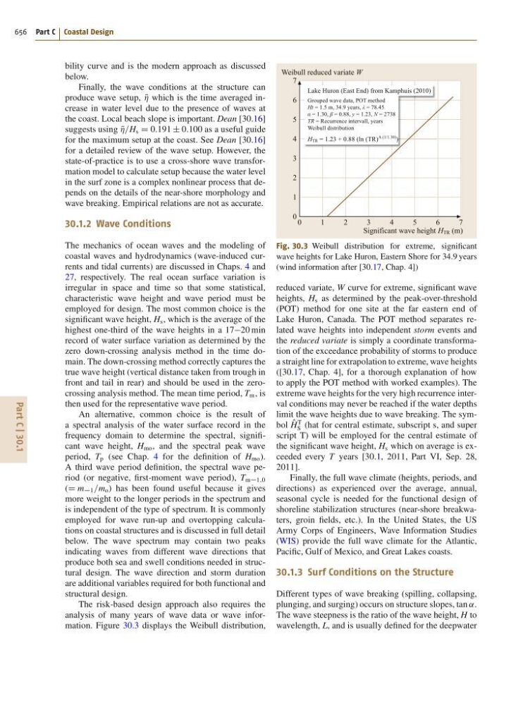
analysis of many years of wave data or wave information. Figure 30.3 displays the Weibull distribution,
Lake Huron (East End) from Kamphuis (2010)
H TR = 1.23 + 0.88 (ln (TR)
A (1/1.30) )
Grouped wave data, POT method
Ht = 1.5 m, 34.9 years, λ = 78.45
α = 1.30, β = 0.88, y = 1.23, N = 2738
TR = Recurrence intervall, years
Weibull distribution
0
1
2
3
4
5
6
7
Weibull reduced variate W
Significant wave height H TR (m)
7
6
5
4
3
2
1
0
Fig. 30.3 Weibull distribution for extreme, significant
wave heights for Lake Huron, Eastern Shore for 34:9 years
(wind information after [30.17, Chap. 4])
reduced variate, W curve for extreme, significant wave
heights, H s as determined by the peak-over-threshold
(POT) method for one site at the far eastern end of
Lake Huron, Canada. The POT method separates related wave heights into independent storm events and
the reduced variate is simply a coordinate transformation of the exceedance probability of storms to produce
a straight line for extrapolation to extreme, wave heights
([30.17, Chap. 4], for a thorough explanation of how
to apply the POT method with worked examples). The
extreme wave heights for the very high recurrence interval conditions may never be reached if the water depths
limit the wave heights due to wave breaking. The symbol O
H
T
S (hat for central estimate, subscript s, and super
script T) will be employed for the central estimate of
the significant wave height, H s which on average is exceeded every T years [30.1, 2011, Part VI, Sep. 28,
2011].
Finally, the full wave climate (heights, periods, and
directions) as experienced over the average, annual,
seasonal cycle is needed for the functional design of
shoreline stabilization structures (near-shore breakwaters, groin fields, etc.). In the United States, the US
Army Corps of Engineers, Wave Information Studies
(WIS) provide the full wave climate for the Atlantic,
Pacific, Gulf of Mexico, and Great Lakes coasts.
30.1.3 Surf Conditions on the Structure
Different types of wave breaking (spilling, collapsing,
plunging, and surging) occurs on structure slopes, tan ˛.
The wave steepness is the ratio of the wave height, H to
wavelength, L, and is usually defined for the deepwater