

Part B | 20.2
462 Part B Autonomous Ocean Vehicles, Subsystems and Control
Field control
Plume forecast
Current plume
Cluster A
Cluster C
Cluster B
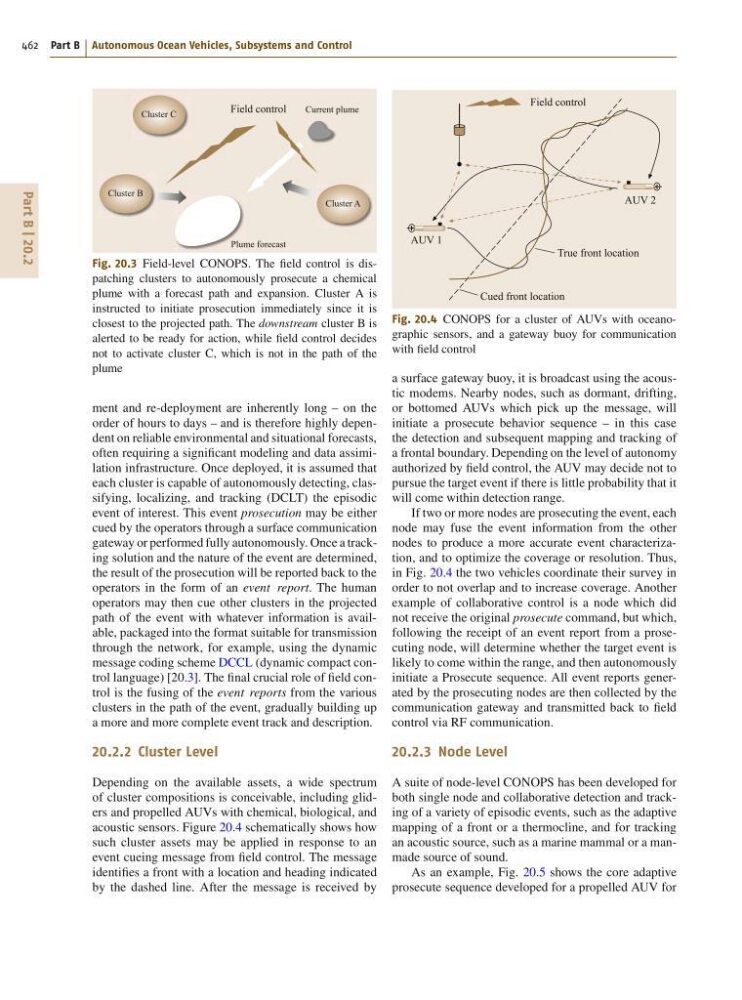
Fig. 20.3 Field-level CONOPS. The field control is dispatching clusters to autonomously prosecute a chemical
plume with a forecast path and expansion. Cluster A is
instructed to initiate prosecution immediately since it is
closest to the projected path. The downstream cluster B is
alerted to be ready for action, while field control decides
not to activate cluster C, which is not in the path of the
plume
ment and re-deployment are inherently long – on the
order of hours to days – and is therefore highly dependent on reliable environmental and situational forecasts,
often requiring a significant modeling and data assimilation infrastructure. Once deployed, it is assumed that
each cluster is capable of autonomously detecting, classifying, localizing, and tracking (DCLT) the episodic
event of interest. This event prosecution may be either
cued by the operators through a surface communication
gateway or performed fully autonomously. Once a tracking solution and the nature of the event are determined,
the result of the prosecution will be reported back to the
operators in the form of an event report. The human
operators may then cue other clusters in the projected
path of the event with whatever information is available, packaged into the format suitable for transmission
through the network, for example, using the dynamic
message coding scheme DCCL (dynamic compact control language) [20.3]. The final crucial role of field control is the fusing of the event reports from the various
clusters in the path of the event, gradually building up
a more and more complete event track and description.
20.2.2 Cluster Level
Depending on the available assets, a wide spectrum
of cluster compositions is conceivable, including gliders and propelled AUVs with chemical, biological, and
acoustic sensors. Figure 20.4 schematically shows how
such cluster assets may be applied in response to an
event cueing message from field control. The message
identifies a front with a location and heading indicated
by the dashed line. After the message is received by
Field control
AUV 1
True front location
Cued front location
AUV 2
Fig. 20.4 CONOPS for a cluster of AUVs with oceanographic sensors, and a gateway buoy for communication
with field control
a surface gateway buoy, it is broadcast using the acoustic modems. Nearby nodes, such as dormant, drifting,
or bottomed AUVs which pick up the message, will
initiate a prosecute behavior sequence – in this case
the detection and subsequent mapping and tracking of
a frontal boundary. Depending on the level of autonomy
authorized by field control, the AUV may decide not to
pursue the target event if there is little probability that it
will come within detection range.
If two or more nodes are prosecuting the event, each
node may fuse the event information from the other
nodes to produce a more accurate event characterization, and to optimize the coverage or resolution. Thus,
in Fig. 20.4 the two vehicles coordinate their survey in
order to not overlap and to increase coverage. Another
example of collaborative control is a node which did
not receive the original prosecute command, but which,
following the receipt of an event report from a prosecuting node, will determine whether the target event is
likely to come within the range, and then autonomously
initiate a Prosecute sequence. All event reports generated by the prosecuting nodes are then collected by the
communication gateway and transmitted back to field
control via RF communication.
20.2.3 Node Level
A suite of node-level CONOPS has been developed for
both single node and collaborative detection and tracking of a variety of episodic events, such as the adaptive
mapping of a front or a thermocline, and for tracking
an acoustic source, such as a marine mammal or a manmade source of sound.
As an example, Fig. 20.5 shows the core adaptive
prosecute sequence developed for a propelled AUV for
462 Part B Autonomous Ocean Vehicles, Subsystems and Control
Field control
Plume forecast
Current plume
Cluster A
Cluster C
Cluster B
Fig. 20.3 Field-level CONOPS. The field control is dispatching clusters to autonomously prosecute a chemical
plume with a forecast path and expansion. Cluster A is
instructed to initiate prosecution immediately since it is
closest to the projected path. The downstream cluster B is
alerted to be ready for action, while field control decides
not to activate cluster C, which is not in the path of the
plume
ment and re-deployment are inherently long – on the
order of hours to days – and is therefore highly dependent on reliable environmental and situational forecasts,
often requiring a significant modeling and data assimilation infrastructure. Once deployed, it is assumed that
each cluster is capable of autonomously detecting, classifying, localizing, and tracking (DCLT) the episodic
event of interest. This event prosecution may be either
cued by the operators through a surface communication
gateway or performed fully autonomously. Once a tracking solution and the nature of the event are determined,
the result of the prosecution will be reported back to the
operators in the form of an event report. The human
operators may then cue other clusters in the projected
path of the event with whatever information is available, packaged into the format suitable for transmission
through the network, for example, using the dynamic
message coding scheme DCCL (dynamic compact control language) [20.3]. The final crucial role of field control is the fusing of the event reports from the various
clusters in the path of the event, gradually building up
a more and more complete event track and description.
20.2.2 Cluster Level
Depending on the available assets, a wide spectrum
of cluster compositions is conceivable, including gliders and propelled AUVs with chemical, biological, and
acoustic sensors. Figure 20.4 schematically shows how
such cluster assets may be applied in response to an
event cueing message from field control. The message
identifies a front with a location and heading indicated
by the dashed line. After the message is received by
Field control
AUV 1
True front location
Cued front location
AUV 2
Fig. 20.4 CONOPS for a cluster of AUVs with oceanographic sensors, and a gateway buoy for communication
with field control
a surface gateway buoy, it is broadcast using the acoustic modems. Nearby nodes, such as dormant, drifting,
or bottomed AUVs which pick up the message, will
initiate a prosecute behavior sequence – in this case
the detection and subsequent mapping and tracking of
a frontal boundary. Depending on the level of autonomy
authorized by field control, the AUV may decide not to
pursue the target event if there is little probability that it
will come within detection range.
If two or more nodes are prosecuting the event, each
node may fuse the event information from the other
nodes to produce a more accurate event characterization, and to optimize the coverage or resolution. Thus,
in Fig. 20.4 the two vehicles coordinate their survey in
order to not overlap and to increase coverage. Another
example of collaborative control is a node which did
not receive the original prosecute command, but which,
following the receipt of an event report from a prosecuting node, will determine whether the target event is
likely to come within the range, and then autonomously
initiate a Prosecute sequence. All event reports generated by the prosecuting nodes are then collected by the
communication gateway and transmitted back to field
control via RF communication.
20.2.3 Node Level
A suite of node-level CONOPS has been developed for
both single node and collaborative detection and tracking of a variety of episodic events, such as the adaptive
mapping of a front or a thermocline, and for tracking
an acoustic source, such as a marine mammal or a manmade source of sound.
As an example, Fig. 20.5 shows the core adaptive
prosecute sequence developed for a propelled AUV for