

Autonomous Underwater Vehicle Navigation 14.2 Algorithms 351
Part B | 14.2
of the mission. Strategies to mitigate this are discussed
in Johannsson et al. [14.82].
SLAM techniques have been used successfully on
a wide range of AUVs, using sonar and image measurements. A key requirement for SLAM is to be able to
extract and match features from measurements obtained
from different vantage points, to extract constraints that
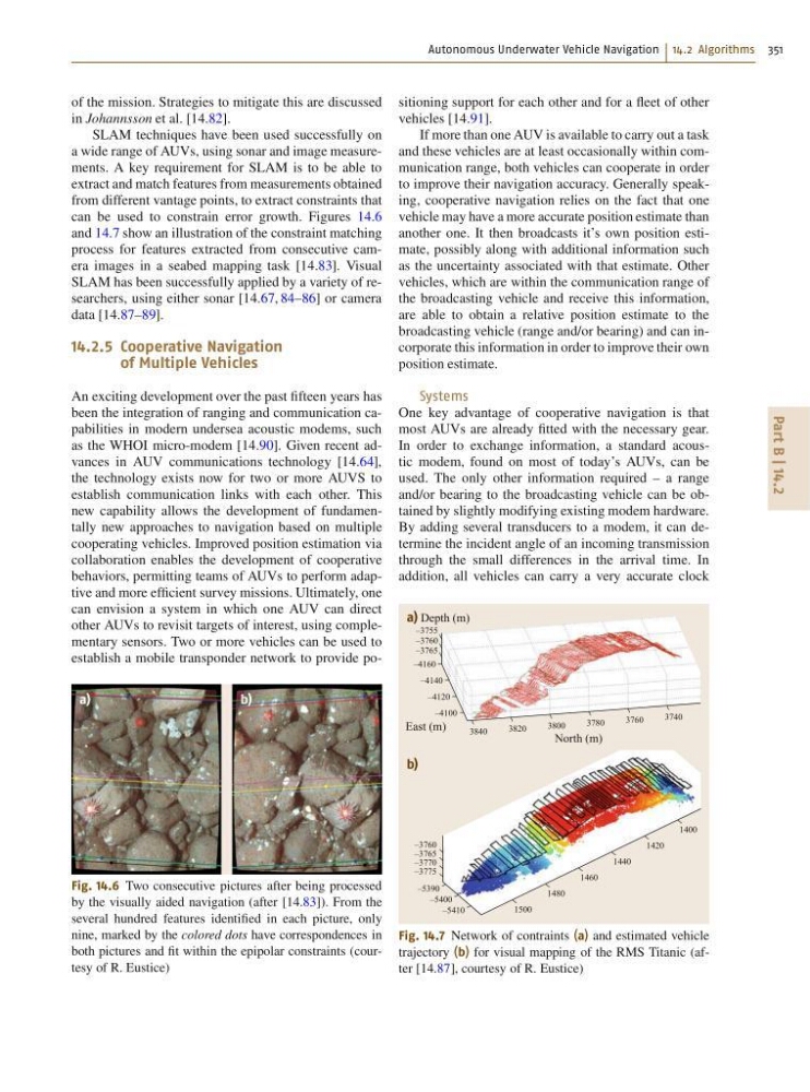
can be used to constrain error growth. Figures 14.6
and 14.7 show an illustration of the constraint matching
process for features extracted from consecutive camera images in a seabed mapping task [14.83]. Visual
SLAM has been successfully applied by a variety of researchers, using either sonar [14.67, 84–86] or camera
data [14.87–89].
14.2.5 Cooperative Navigation
of Multiple Vehicles
An exciting development over the past fifteen years has
been the integration of ranging and communication capabilities in modern undersea acoustic modems, such
as the WHOI micro-modem [14.90]. Given recent advances in AUV communications technology [14.64],
the technology exists now for two or more AUVS to
establish communication links with each other. This
new capability allows the development of fundamentally new approaches to navigation based on multiple
cooperating vehicles. Improved position estimation via
collaboration enables the development of cooperative
behaviors, permitting teams of AUVs to perform adaptive and more efficient survey missions. Ultimately, one
can envision a system in which one AUV can direct
other AUVs to revisit targets of interest, using complementary sensors. Two or more vehicles can be used to
establish a mobile transponder network to provide poa)
b)
Fig. 14.6 Two consecutive pictures after being processed
by the visually aided navigation (after [14.83]). From the
several hundred features identified in each picture, only
nine, marked by the colored dots have correspondences in
both pictures and fit within the epipolar constraints (courtesy of R. Eustice)
sitioning support for each other and for a fleet of other
vehicles [14.91].
If more than one AUV is available to carry out a task
and these vehicles are at least occasionally within communication range, both vehicles can cooperate in order
to improve their navigation accuracy. Generally speaking, cooperative navigation relies on the fact that one
vehicle may have a more accurate position estimate than
another one. It then broadcasts it’s own position estimate, possibly along with additional information such
as the uncertainty associated with that estimate. Other
vehicles, which are within the communication range of
the broadcasting vehicle and receive this information,
are able to obtain a relative position estimate to the
broadcasting vehicle (range and/or bearing) and can incorporate this information in order to improve their own
position estimate.
Systems
One key advantage of cooperative navigation is that
most AUVs are already fitted with the necessary gear.
In order to exchange information, a standard acoustic modem, found on most of today’s AUVs, can be
used. The only other information required – a range
and/or bearing to the broadcasting vehicle can be obtained by slightly modifying existing modem hardware.
By adding several transducers to a modem, it can determine the incident angle of an incoming transmission
through the small differences in the arrival time. In
addition, all vehicles can carry a very accurate clock
a) Depth (m)
b)
–3755
–3760
–3765
–4160
3840
3820
3800
3780
3760
3740
–4140
–4120
–4100
East (m)
–3760
–3765
–3770
–3775
1500
1480
1460
1440
1420
1400
–5390
–5400
–5410
North (m)
Fig. 14.7 Network of contraints (a) and estimated vehicle
trajectory (b) for visual mapping of the RMS Titanic (after [14.87], courtesy of R. Eustice)
Part B | 14.2
of the mission. Strategies to mitigate this are discussed
in Johannsson et al. [14.82].
SLAM techniques have been used successfully on
a wide range of AUVs, using sonar and image measurements. A key requirement for SLAM is to be able to
extract and match features from measurements obtained
from different vantage points, to extract constraints that
can be used to constrain error growth. Figures 14.6
and 14.7 show an illustration of the constraint matching
process for features extracted from consecutive camera images in a seabed mapping task [14.83]. Visual
SLAM has been successfully applied by a variety of researchers, using either sonar [14.67, 84–86] or camera
data [14.87–89].
14.2.5 Cooperative Navigation
of Multiple Vehicles
An exciting development over the past fifteen years has
been the integration of ranging and communication capabilities in modern undersea acoustic modems, such
as the WHOI micro-modem [14.90]. Given recent advances in AUV communications technology [14.64],
the technology exists now for two or more AUVS to
establish communication links with each other. This
new capability allows the development of fundamentally new approaches to navigation based on multiple
cooperating vehicles. Improved position estimation via
collaboration enables the development of cooperative
behaviors, permitting teams of AUVs to perform adaptive and more efficient survey missions. Ultimately, one
can envision a system in which one AUV can direct
other AUVs to revisit targets of interest, using complementary sensors. Two or more vehicles can be used to
establish a mobile transponder network to provide poa)
b)
Fig. 14.6 Two consecutive pictures after being processed
by the visually aided navigation (after [14.83]). From the
several hundred features identified in each picture, only
nine, marked by the colored dots have correspondences in
both pictures and fit within the epipolar constraints (courtesy of R. Eustice)
sitioning support for each other and for a fleet of other
vehicles [14.91].
If more than one AUV is available to carry out a task
and these vehicles are at least occasionally within communication range, both vehicles can cooperate in order
to improve their navigation accuracy. Generally speaking, cooperative navigation relies on the fact that one
vehicle may have a more accurate position estimate than
another one. It then broadcasts it’s own position estimate, possibly along with additional information such
as the uncertainty associated with that estimate. Other
vehicles, which are within the communication range of
the broadcasting vehicle and receive this information,
are able to obtain a relative position estimate to the
broadcasting vehicle (range and/or bearing) and can incorporate this information in order to improve their own
position estimate.
Systems
One key advantage of cooperative navigation is that
most AUVs are already fitted with the necessary gear.
In order to exchange information, a standard acoustic modem, found on most of today’s AUVs, can be
used. The only other information required – a range
and/or bearing to the broadcasting vehicle can be obtained by slightly modifying existing modem hardware.
By adding several transducers to a modem, it can determine the incident angle of an incoming transmission
through the small differences in the arrival time. In
addition, all vehicles can carry a very accurate clock
a) Depth (m)
b)
–3755
–3760
–3765
–4160
3840
3820
3800
3780
3760
3740
–4140
–4120
–4100
East (m)
–3760
–3765
–3770
–3775
1500
1480
1460
1440
1420
1400
–5390
–5400
–5410
North (m)
Fig. 14.7 Network of contraints (a) and estimated vehicle
trajectory (b) for visual mapping of the RMS Titanic (after [14.87], courtesy of R. Eustice)