

71
Comparative Analysis of Surface Energy Balance Models
is characterized by a typical Mediterranean climate with moderate rainfall during
autumn and winter periods, very high air temperature, and little precipitation during
summer months. In the period 2005–2008, the total annual rainfall ranged between
450 and 650 mm, whereas the atmospheric evaporative demand was between 1000
and 1200 mm. The morphology of the area is prevalently flat, and soils are mainly
alluvial deposits characterized by loam and sandy loam textures.
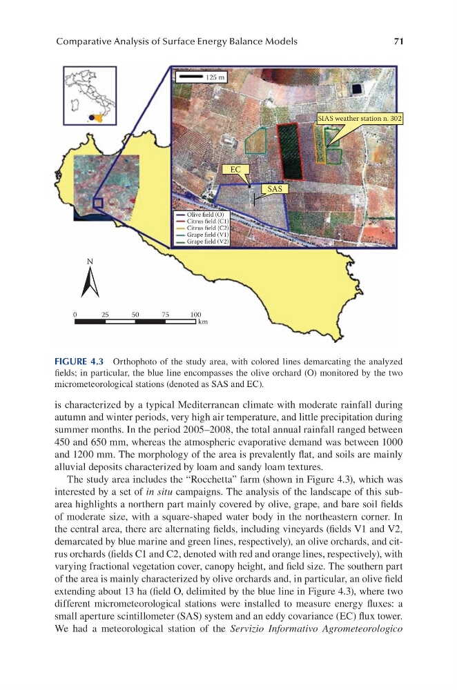
The study area includes the “Rocchetta” farm (shown in Figure 4.3), which was
interested by a set of in situ campaigns. The analysis of the landscape of this subarea highlights a northern part mainly covered by olive, grape, and bare soil fields
of moderate size, with a square-shaped water body in the northeastern corner. In
the central area, there are alternating fields, including vineyards (fields V1 and V2,
demarcated by blue marine and green lines, respectively), an olive orchards, and citrus orchards (fields C1 and C2, denoted with red and orange lines, respectively), with
varying fractional vegetation cover, canopy height, and field size. The southern part
of the area is mainly characterized by olive orchards and, in particular, an olive field
extending about 13 ha (field O, delimited by the blue line in Figure 4.3), where two
different micrometeorological stations were installed to measure energy fluxes: a
small aperture scintillometer (SAS) system and an eddy covariance (EC) flux tower.
We had a meteorological station of the Servizio Informativo Agrometeorologico
EC
125 m
SAS
SIAS weather station n. 302
Olive field (O)
Citrus field (C1)
Citrus field (C2)
Grape field (V1)
Grape field (V2)
N
0
25
50
75
100
km
FIGURE 4.3 Orthophoto of the study area, with colored lines demarcating the analyzed
fields; in particular, the blue line encompasses the olive orchard (O) monitored by the two
micrometeorological stations (denoted as SAS and EC).
Comparative Analysis of Surface Energy Balance Models
is characterized by a typical Mediterranean climate with moderate rainfall during
autumn and winter periods, very high air temperature, and little precipitation during
summer months. In the period 2005–2008, the total annual rainfall ranged between
450 and 650 mm, whereas the atmospheric evaporative demand was between 1000
and 1200 mm. The morphology of the area is prevalently flat, and soils are mainly
alluvial deposits characterized by loam and sandy loam textures.
The study area includes the “Rocchetta” farm (shown in Figure 4.3), which was
interested by a set of in situ campaigns. The analysis of the landscape of this subarea highlights a northern part mainly covered by olive, grape, and bare soil fields
of moderate size, with a square-shaped water body in the northeastern corner. In
the central area, there are alternating fields, including vineyards (fields V1 and V2,
demarcated by blue marine and green lines, respectively), an olive orchards, and citrus orchards (fields C1 and C2, denoted with red and orange lines, respectively), with
varying fractional vegetation cover, canopy height, and field size. The southern part
of the area is mainly characterized by olive orchards and, in particular, an olive field
extending about 13 ha (field O, delimited by the blue line in Figure 4.3), where two
different micrometeorological stations were installed to measure energy fluxes: a
small aperture scintillometer (SAS) system and an eddy covariance (EC) flux tower.
We had a meteorological station of the Servizio Informativo Agrometeorologico
EC
125 m
SAS
SIAS weather station n. 302
Olive field (O)
Citrus field (C1)
Citrus field (C2)
Grape field (V1)
Grape field (V2)
N
0
25
50
75
100
km
FIGURE 4.3 Orthophoto of the study area, with colored lines demarcating the analyzed
fields; in particular, the blue line encompasses the olive orchard (O) monitored by the two
micrometeorological stations (denoted as SAS and EC).