

518
Multiscale Hydrologic Remote Sensing: Perspectives and Applications
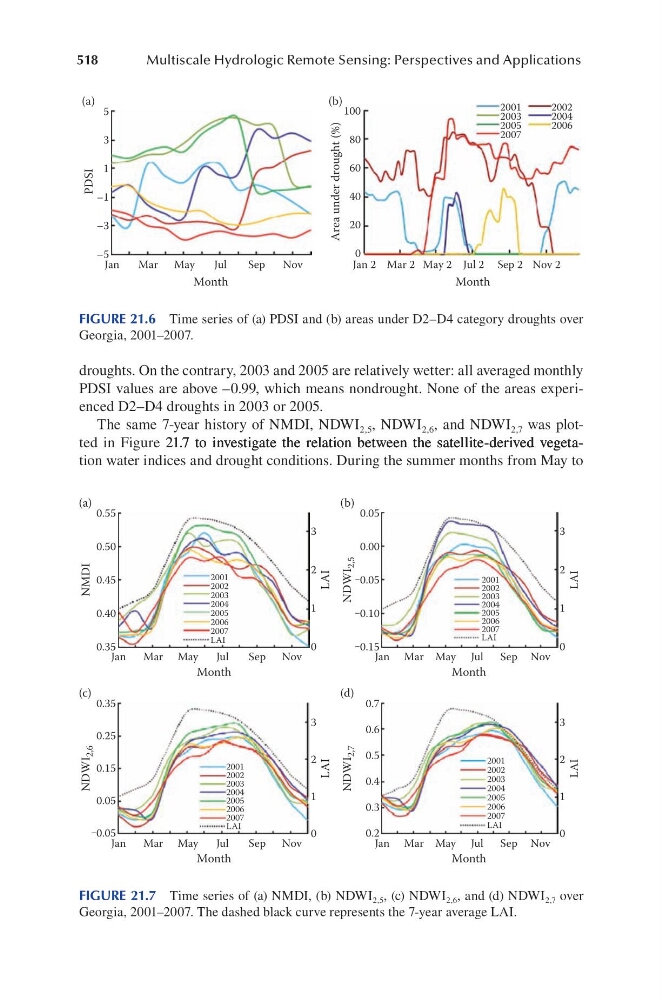
droughts. On the contrary, 2003 and 2005 are relatively wetter: all averaged monthly
PDSI values are above –0.99, which means nondrought. None of the areas experienced D2–D4 droughts in 2003 or 2005.
The same 7-year history of NMDI, NDWI 2,5 , NDWI 2,6 , and NDWI 2,7 was plotted in Figure 21.7 to investigate the relation between the satellite-derived vegeta21.7 to investigate the relation between the satellite-derived vegeta.7 to investigate the relation between the satellite-derived vegetation water indices and drought conditions. During the summer months from May to
(a)
(b)
5
100
80
60
40
20
0
3
1
–1
–3
–5
Jan
Jan 2 Mar 2 May 2 Jul 2 Sep 2 Nov 2
Mar May
Jul
Sep
Nov
Month
Month
PDSI
Area under drought (%)
2001
2003
2005
2007
2002
2004
2006
FIGURE 21.6 Time series of (a) PDSI and (b) areas under D2–D4 category droughts over
Georgia, 2001–2007.
0.55
3
2
1
0
0.50
0.45
0.40
0.35
0.05
0.00
‒0.05
‒0.10
‒0.15
Jan
Mar May
Jul
Sep Nov
Month
LAI
NMDI
NDWI
2,5
Jan Mar May Jul Sep Nov
Month
Jan
Mar May
Jul
Sep Nov
Month
Jan Mar May Jul Sep Nov
Month
0.35
3
2
1
0
0.25
0.15
0.05
‒0.05
0.7
0.6
0.5
0.4
0.3
0.2
LAI
3
2
1
0
LAI
3
2
1
0
LAI
NDWI
2,6
NDWI
2,7
2001
2002
2003
2004
2005
2006
2007
LAI
2001
2002
2003
2004
2005
2006
2007
LAI
2001
2002
2003
2004
2005
2006
2007
LAI
2001
2002
2003
2004
2005
2006
2007
LAI
(a)
(b)
(c)
(d)
FIGURE 21.7 Time series of (a) NMDI, (b) NDWI 2,5 , (c) NDWI 2,6 , and (d) NDWI 2,7 over
Georgia, 2001–2007. The dashed black curve represents the 7-year average LAI.
Multiscale Hydrologic Remote Sensing: Perspectives and Applications
droughts. On the contrary, 2003 and 2005 are relatively wetter: all averaged monthly
PDSI values are above –0.99, which means nondrought. None of the areas experienced D2–D4 droughts in 2003 or 2005.
The same 7-year history of NMDI, NDWI 2,5 , NDWI 2,6 , and NDWI 2,7 was plotted in Figure 21.7 to investigate the relation between the satellite-derived vegeta21.7 to investigate the relation between the satellite-derived vegeta.7 to investigate the relation between the satellite-derived vegetation water indices and drought conditions. During the summer months from May to
(a)
(b)
5
100
80
60
40
20
0
3
1
–1
–3
–5
Jan
Jan 2 Mar 2 May 2 Jul 2 Sep 2 Nov 2
Mar May
Jul
Sep
Nov
Month
Month
PDSI
Area under drought (%)
2001
2003
2005
2007
2002
2004
2006
FIGURE 21.6 Time series of (a) PDSI and (b) areas under D2–D4 category droughts over
Georgia, 2001–2007.
0.55
3
2
1
0
0.50
0.45
0.40
0.35
0.05
0.00
‒0.05
‒0.10
‒0.15
Jan
Mar May
Jul
Sep Nov
Month
LAI
NMDI
NDWI
2,5
Jan Mar May Jul Sep Nov
Month
Jan
Mar May
Jul
Sep Nov
Month
Jan Mar May Jul Sep Nov
Month
0.35
3
2
1
0
0.25
0.15
0.05
‒0.05
0.7
0.6
0.5
0.4
0.3
0.2
LAI
3
2
1
0
LAI
3
2
1
0
LAI
NDWI
2,6
NDWI
2,7
2001
2002
2003
2004
2005
2006
2007
LAI
2001
2002
2003
2004
2005
2006
2007
LAI
2001
2002
2003
2004
2005
2006
2007
LAI
2001
2002
2003
2004
2005
2006
2007
LAI
(a)
(b)
(c)
(d)
FIGURE 21.7 Time series of (a) NMDI, (b) NDWI 2,5 , (c) NDWI 2,6 , and (d) NDWI 2,7 over
Georgia, 2001–2007. The dashed black curve represents the 7-year average LAI.