

471
Remote Sensing and Modeling of Global Evapotranspiration
19.8 CONCLUSIONS
The terrestrial water cycle plays a central role in climate and meteorology, plant
community dynamics, and carbon and nutrient biogeochemistry. ET is the second
largest component (after precipitation) of the terrestrial water cycle at the global
scale and thereby conveys an important constraint on water availability at the land
surface. Accurate estimation of ET not only meets the growing competition for the
limited water supplies and the need to reduce the cost of the irrigation projects but
also is essential to projecting potential changes in the global hydrological cycle
under different climate change scenarios. Remote sensing data sometimes can also
detect mechanisms not observable with field measurements, and remote sensing data
may even assist in selecting appropriate sites for field observations and help validate
or drive hydrological models. ET can be used to calculate regional water and energy
balance and soil water status; hence, it provides key information for water resource
management. With long-term ET data, the effects of changes in climate, land use,
and ecosystem disturbances (e.g., wildfires and insect outbreaks) on regional water
resources and land surface energy changes can be quantified. With the improved
quality and increasing spatial coverage of ground-based data, improved quality of
satellite data, and the increasing knowledge gained from these data, the performance
of ET models will continue to be enhanced, thereby enhancing our ability to study
the earth as a system.
REFERENCES
Asner, G. P., Scurlock, J. M. O., and Hicke, J. A. (2003). Global synthesis of leaf area index
observations: Implications for ecological and remote sensing studies. Global Ecology
and Biogeography, 12, 191–205.
0
250
500
750
Global annual MODIS ET (2000–2010) mm ∙ year –1
1000
1250
1500
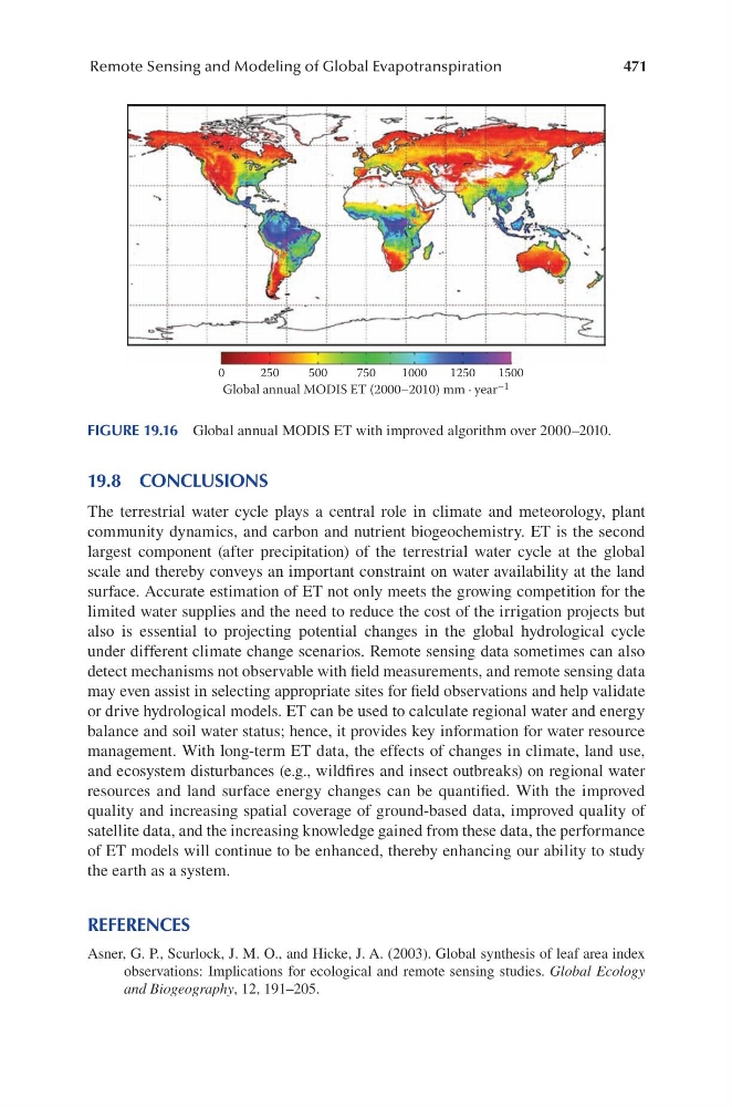
FIGURE 19.16 Global annual MODIS ET with improved algorithm over 2000–2010.
Remote Sensing and Modeling of Global Evapotranspiration
19.8 CONCLUSIONS
The terrestrial water cycle plays a central role in climate and meteorology, plant
community dynamics, and carbon and nutrient biogeochemistry. ET is the second
largest component (after precipitation) of the terrestrial water cycle at the global
scale and thereby conveys an important constraint on water availability at the land
surface. Accurate estimation of ET not only meets the growing competition for the
limited water supplies and the need to reduce the cost of the irrigation projects but
also is essential to projecting potential changes in the global hydrological cycle
under different climate change scenarios. Remote sensing data sometimes can also
detect mechanisms not observable with field measurements, and remote sensing data
may even assist in selecting appropriate sites for field observations and help validate
or drive hydrological models. ET can be used to calculate regional water and energy
balance and soil water status; hence, it provides key information for water resource
management. With long-term ET data, the effects of changes in climate, land use,
and ecosystem disturbances (e.g., wildfires and insect outbreaks) on regional water
resources and land surface energy changes can be quantified. With the improved
quality and increasing spatial coverage of ground-based data, improved quality of
satellite data, and the increasing knowledge gained from these data, the performance
of ET models will continue to be enhanced, thereby enhancing our ability to study
the earth as a system.
REFERENCES
Asner, G. P., Scurlock, J. M. O., and Hicke, J. A. (2003). Global synthesis of leaf area index
observations: Implications for ecological and remote sensing studies. Global Ecology
and Biogeography, 12, 191–205.
0
250
500
750
Global annual MODIS ET (2000–2010) mm ∙ year –1
1000
1250
1500
FIGURE 19.16 Global annual MODIS ET with improved algorithm over 2000–2010.