

373
Global Precipitation Estimation and Applications
has been succeeding in producing precipitation data of 2.5° × 2.5° (latitude–
longitude) monthly accumulations of estimates since 1979 (Adler et al. 2003), as
shown in Figure 15.1. Since 1996, the daily 1° gridded rainfall product has been
archived under the auspices of the Global Energy and Water Cycle Experiment. In
recent years, numerous applications of hydrology and water resource management
have imposed a growing need for precipitation measurements at subdaily sampling
frequencies (3-h or hourly) and higher spatial resolutions (25 km or down to geostationary satellite pixel resolution, 4 km). These satellite-based high-resolution precipitation products have been developed by combining information from IR, VIS, and
MW observations (Hsu et al. 1997; Sorooshian et al. 2000; Kidd et al. 2003; Hong et
al. 2004; Joyce et al. 2004; Turk and Miller 2005; Huffman et al. 2007).
This chapter provides an overview of satellite remote sensing precipitation estimation sensors, algorithms, and products. Then we briefly introduce potential hydrologic applications of the global precipitation datasets. It leads to the application of a
distributed hydrological model for global and regional flood predictions.
15.2 SATELLITE SENSORS AND PRECIPITATION RETRIEVAL
15.2.1 Review of Satellite SenSoRS
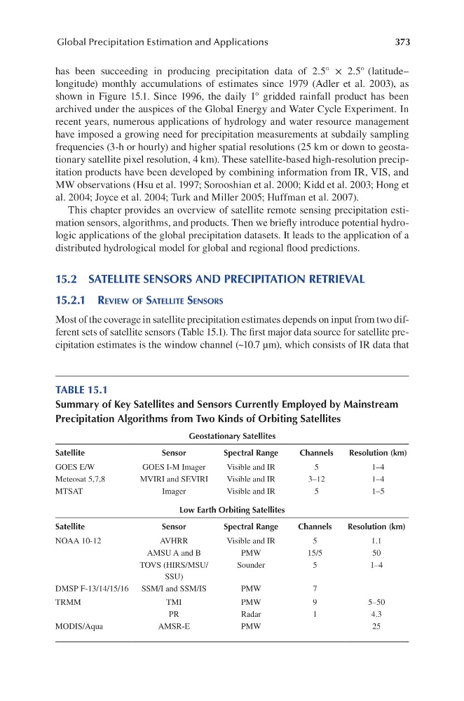
Most of the coverage in satellite precipitation estimates depends on input from two different sets of satellite sensors (Table 15.1). The first major data source for satellite precipitation estimates is the window channel (~10.7 µm), which consists of IR data that
TABLE 15.1
Summary of Key Satellites and Sensors Currently Employed by Mainstream
Precipitation Algorithms from Two Kinds of Orbiting Satellites
Geostationary Satellites
Satellite
Sensor
Spectral Range
Channels
Resolution (km)
GOES E/W
GOES I-M Imager
Visible and IR
5
1–4
Meteosat 5,7,8
MVIRI and SEVIRI
Visible and IR
3–12
1–4
MTSAT
Imager
Visible and IR
5
1–5
Low Earth Orbiting Satellites
Satellite
Sensor
Spectral Range
Channels
Resolution (km)
NOAA 10-12
AVHRR
Visible and IR
5
1.1
AMSU A and B
PMW
15/5
50
TOVS (HIRS/MSU/
SSU)
Sounder
5
1–4
DMSP F-13/14/15/16
SSM/I and SSM/IS
PMW
7
TRMM
TMI
PMW
9
5–50
PR
Radar
1
4.3
MODIS/Aqua
AMSR-E
PMW
25
Global Precipitation Estimation and Applications
has been succeeding in producing precipitation data of 2.5° × 2.5° (latitude–
longitude) monthly accumulations of estimates since 1979 (Adler et al. 2003), as
shown in Figure 15.1. Since 1996, the daily 1° gridded rainfall product has been
archived under the auspices of the Global Energy and Water Cycle Experiment. In
recent years, numerous applications of hydrology and water resource management
have imposed a growing need for precipitation measurements at subdaily sampling
frequencies (3-h or hourly) and higher spatial resolutions (25 km or down to geostationary satellite pixel resolution, 4 km). These satellite-based high-resolution precipitation products have been developed by combining information from IR, VIS, and
MW observations (Hsu et al. 1997; Sorooshian et al. 2000; Kidd et al. 2003; Hong et
al. 2004; Joyce et al. 2004; Turk and Miller 2005; Huffman et al. 2007).
This chapter provides an overview of satellite remote sensing precipitation estimation sensors, algorithms, and products. Then we briefly introduce potential hydrologic applications of the global precipitation datasets. It leads to the application of a
distributed hydrological model for global and regional flood predictions.
15.2 SATELLITE SENSORS AND PRECIPITATION RETRIEVAL
15.2.1 Review of Satellite SenSoRS
Most of the coverage in satellite precipitation estimates depends on input from two different sets of satellite sensors (Table 15.1). The first major data source for satellite precipitation estimates is the window channel (~10.7 µm), which consists of IR data that
TABLE 15.1
Summary of Key Satellites and Sensors Currently Employed by Mainstream
Precipitation Algorithms from Two Kinds of Orbiting Satellites
Geostationary Satellites
Satellite
Sensor
Spectral Range
Channels
Resolution (km)
GOES E/W
GOES I-M Imager
Visible and IR
5
1–4
Meteosat 5,7,8
MVIRI and SEVIRI
Visible and IR
3–12
1–4
MTSAT
Imager
Visible and IR
5
1–5
Low Earth Orbiting Satellites
Satellite
Sensor
Spectral Range
Channels
Resolution (km)
NOAA 10-12
AVHRR
Visible and IR
5
1.1
AMSU A and B
PMW
15/5
50
TOVS (HIRS/MSU/
SSU)
Sounder
5
1–4
DMSP F-13/14/15/16
SSM/I and SSM/IS
PMW
7
TRMM
TMI
PMW
9
5–50
PR
Radar
1
4.3
MODIS/Aqua
AMSR-E
PMW
25