

372
Multiscale Hydrologic Remote Sensing: Perspectives and Applications
point measurements of precipitation; however, they suffer from poor spatial coverage
and lack of areal representation over land, which becomes particularly problematic
for intense rainfall with high spatial variability. The development of weather radar
after World War II has dramatically increased our ability to measure high-resolution
precipitation data in space and time. For example, with the available radar systems,
regional-scale studies can be performed across the United States, Western Europe,
and a few other regions across the globe. However, precipitation observations from
rain gauge networks and weather radar systems are inadequate for obtaining global
precipitation products and evaluation of weather and climate models at global scales,
particularly in oceanic, remote, or developing regions. Even in the United States,
many mountainous regions (e.g., Western United States) also suffer from poor
ground radar coverage due to significant blockage. The limitations of rain gauges
and weather radar systems highlight the attraction of space-based meteorological
satellites to measure global precipitation data for hydrological cycle and climate
studies.
The estimation of precipitation on a global basis is therefore only viable through
the utilization of Earth observation satellites. The first meteorological satellite
was launched in 1960, and since then, a plethora of sensors have been developed
and launched to observe the atmosphere (Gruber and Levizzani 2008). These sensors fall into two main categories: visible/infrared (VIS/IR) sensors available
from Geosynchronous Earth Orbit (GEO) and Low-Earth Orbiting (LEO) satellites, and microwave (MW) sensors, currently only available from LEO satellites.
Consequently, researchers have come to blend VIS/IR and MW sensors flying on GEO
or LEO satellites over the last three decades for the majority of the information used
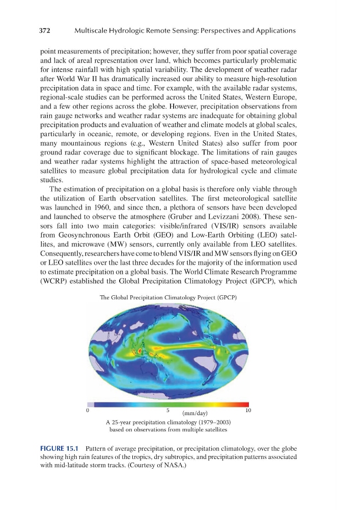
to estimate precipitation on a global basis. The World Climate Research Programme
(WCRP) established the Global Precipitation Climatology Project (GPCP), which
e Global Precipitation Climatology Project (GPCP)
0
5
10
(mm/day)
A 25-year precipitation climatology (1979–2003)
based on observations from multiple satellites
FIGURE 15.1 Pattern of average precipitation, or precipitation climatology, over the globe
showing high rain features of the tropics, dry subtropics, and precipitation patterns associated
with mid-latitude storm tracks. (Courtesy of NASA.)
Multiscale Hydrologic Remote Sensing: Perspectives and Applications
point measurements of precipitation; however, they suffer from poor spatial coverage
and lack of areal representation over land, which becomes particularly problematic
for intense rainfall with high spatial variability. The development of weather radar
after World War II has dramatically increased our ability to measure high-resolution
precipitation data in space and time. For example, with the available radar systems,
regional-scale studies can be performed across the United States, Western Europe,
and a few other regions across the globe. However, precipitation observations from
rain gauge networks and weather radar systems are inadequate for obtaining global
precipitation products and evaluation of weather and climate models at global scales,
particularly in oceanic, remote, or developing regions. Even in the United States,
many mountainous regions (e.g., Western United States) also suffer from poor
ground radar coverage due to significant blockage. The limitations of rain gauges
and weather radar systems highlight the attraction of space-based meteorological
satellites to measure global precipitation data for hydrological cycle and climate
studies.
The estimation of precipitation on a global basis is therefore only viable through
the utilization of Earth observation satellites. The first meteorological satellite
was launched in 1960, and since then, a plethora of sensors have been developed
and launched to observe the atmosphere (Gruber and Levizzani 2008). These sensors fall into two main categories: visible/infrared (VIS/IR) sensors available
from Geosynchronous Earth Orbit (GEO) and Low-Earth Orbiting (LEO) satellites, and microwave (MW) sensors, currently only available from LEO satellites.
Consequently, researchers have come to blend VIS/IR and MW sensors flying on GEO
or LEO satellites over the last three decades for the majority of the information used
to estimate precipitation on a global basis. The World Climate Research Programme
(WCRP) established the Global Precipitation Climatology Project (GPCP), which
e Global Precipitation Climatology Project (GPCP)
0
5
10
(mm/day)
A 25-year precipitation climatology (1979–2003)
based on observations from multiple satellites
FIGURE 15.1 Pattern of average precipitation, or precipitation climatology, over the globe
showing high rain features of the tropics, dry subtropics, and precipitation patterns associated
with mid-latitude storm tracks. (Courtesy of NASA.)