

16
Multiscale Hydrologic Remote Sensing: Perspectives and Applications
requires prior knowledge of the porosity of the soil material and permittivities of the
individual constituents.
2.4 VALIDATION AND APPLICATIONS
The developed GPR method was widely validated in laboratory experiments in different soil configurations, including two-layered soil structure (Lambot et al. 2004a),
shallow soil layering (Lambot et al. 2006; Minet et al. 2010), continuously varying soil moisture profile (Lambot et al. 2004b), and the presence of high electrical
conductivity (Lambot et al. 2006). Herein, validation and applications of the GPR
method for soil moisture sensing and mapping in field conditions are presented.
2.4.1 MaPPing of Soil MoiStuRe in agRicultuRal fieldS
An important asset of using off-ground GPR in proximal soil sensing applications
is that no contact with soil is required, thereby allowing for fast acquisition without
“stop-and-go” of the acquisition platform. For field acquisition, the GPR system
was mounted on an all-terrain vehicle (ATV) with an accurate Global Positioning
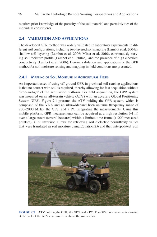
System (GPS). Figure 2.1 presents the ATV holding the GPR system, which is
composed of the VNA and an ultrawideband horn antenna (frequency range of
200–2000 MHz), the GPS, and a PC integrating the measurements. Using this
mobile platform, GPR measurements can be acquired at a high resolution (~1 m)
over a large extent (several hectares) within a limited time frame (>1000 measured
points/h). GPR inversion allows for retrieving soil dielectric permittivity values
that were translated in soil moisture using Equation 2.6 and then interpolated. Soil
FIGURE 2.1 ATV holding the GPR, the GPS, and a PC. The GPR horn antenna is situated
at the back of the ATV at around 1 m above the soil surface.
Multiscale Hydrologic Remote Sensing: Perspectives and Applications
requires prior knowledge of the porosity of the soil material and permittivities of the
individual constituents.
2.4 VALIDATION AND APPLICATIONS
The developed GPR method was widely validated in laboratory experiments in different soil configurations, including two-layered soil structure (Lambot et al. 2004a),
shallow soil layering (Lambot et al. 2006; Minet et al. 2010), continuously varying soil moisture profile (Lambot et al. 2004b), and the presence of high electrical
conductivity (Lambot et al. 2006). Herein, validation and applications of the GPR
method for soil moisture sensing and mapping in field conditions are presented.
2.4.1 MaPPing of Soil MoiStuRe in agRicultuRal fieldS
An important asset of using off-ground GPR in proximal soil sensing applications
is that no contact with soil is required, thereby allowing for fast acquisition without
“stop-and-go” of the acquisition platform. For field acquisition, the GPR system
was mounted on an all-terrain vehicle (ATV) with an accurate Global Positioning
System (GPS). Figure 2.1 presents the ATV holding the GPR system, which is
composed of the VNA and an ultrawideband horn antenna (frequency range of
200–2000 MHz), the GPS, and a PC integrating the measurements. Using this
mobile platform, GPR measurements can be acquired at a high resolution (~1 m)
over a large extent (several hectares) within a limited time frame (>1000 measured
points/h). GPR inversion allows for retrieving soil dielectric permittivity values
that were translated in soil moisture using Equation 2.6 and then interpolated. Soil
FIGURE 2.1 ATV holding the GPR, the GPS, and a PC. The GPR horn antenna is situated
at the back of the ATV at around 1 m above the soil surface.