

257
Multispectral Satellite Data for Flood Monitoring and Inundation Mapping
32° E 34° E 36° E
N
Discharge station
Rain gauge
Nzoia basin
Nzoia River
Lake Victoria
Country boundaries
High : 4138
Low : 1133
Topography (m)
2° S
0°
2° N
0°
0 100 200
Uganda
Kenya
Kenya
Uganda
Congo
Tanzania
Nzoia River
400 600
Km
20° E 40° E
30° S 10° S 10° N
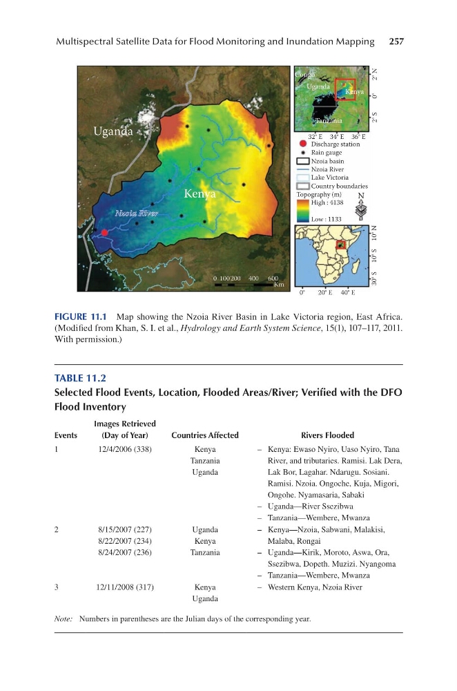
FIGURE 11.1 Map showing the Nzoia River Basin in Lake Victoria region, East Africa.
(Modified from Khan, S. I. et al., Hydrology and Earth System Science, 15(1), 107–117, 2011.
With permission.)
TABLE 11.2
Selected Flood Events, Location, Flooded Areas/River; Verified with the DFO
Flood Inventory
Events
Images Retrieved
(Day of Year)
Countries Affected
Rivers Flooded
1
12/4/2006 (338)
Kenya
Tanzania
Uganda
– Kenya: Ewaso Nyiro, Uaso Nyiro, Tana
River, and tributaries. Ramisi. Lak Dera,
Lak Bor, Lagahar. Ndarugu. Sosiani.
Ramisi. Nzoia. Ongoche, Kuja, Migori,
Ongohe. Nyamasaria, Sabaki
– Uganda—River Ssezibwa
– Tanzania—Wembere, Mwanza
2
8/15/2007 (227)
8/22/2007 (234)
8/24/2007 (236)
Uganda
Kenya
Tanzania
– Kenya—Nzoia, Sabwani, Malakisi,
Malaba, Rongai
– Uganda—Kirik, Moroto, Aswa, Ora,
Ssezibwa, Dopeth. Muzizi. Nyangoma
– Tanzania—Wembere, Mwanza
3
12/11/2008 (317)
Kenya
Uganda
– Western Kenya, Nzoia River
Note: Numbers in parentheses are the Julian days of the corresponding year.
Multispectral Satellite Data for Flood Monitoring and Inundation Mapping
32° E 34° E 36° E
N
Discharge station
Rain gauge
Nzoia basin
Nzoia River
Lake Victoria
Country boundaries
High : 4138
Low : 1133
Topography (m)
2° S
0°
2° N
0°
0 100 200
Uganda
Kenya
Kenya
Uganda
Congo
Tanzania
Nzoia River
400 600
Km
20° E 40° E
30° S 10° S 10° N
FIGURE 11.1 Map showing the Nzoia River Basin in Lake Victoria region, East Africa.
(Modified from Khan, S. I. et al., Hydrology and Earth System Science, 15(1), 107–117, 2011.
With permission.)
TABLE 11.2
Selected Flood Events, Location, Flooded Areas/River; Verified with the DFO
Flood Inventory
Events
Images Retrieved
(Day of Year)
Countries Affected
Rivers Flooded
1
12/4/2006 (338)
Kenya
Tanzania
Uganda
– Kenya: Ewaso Nyiro, Uaso Nyiro, Tana
River, and tributaries. Ramisi. Lak Dera,
Lak Bor, Lagahar. Ndarugu. Sosiani.
Ramisi. Nzoia. Ongoche, Kuja, Migori,
Ongohe. Nyamasaria, Sabaki
– Uganda—River Ssezibwa
– Tanzania—Wembere, Mwanza
2
8/15/2007 (227)
8/22/2007 (234)
8/24/2007 (236)
Uganda
Kenya
Tanzania
– Kenya—Nzoia, Sabwani, Malakisi,
Malaba, Rongai
– Uganda—Kirik, Moroto, Aswa, Ora,
Ssezibwa, Dopeth. Muzizi. Nyangoma
– Tanzania—Wembere, Mwanza
3
12/11/2008 (317)
Kenya
Uganda
– Western Kenya, Nzoia River
Note: Numbers in parentheses are the Julian days of the corresponding year.