

201
MODIS-Based Snow Cover Products, Validation, and Hydrologic Applications
Bocchiola and Groppelli
(2010)
Adamello Park, Northern Italy, 2007–2008
SWE interpolation
Gillan et al. (2010)
MOD10A1, MOD10A2
Western Montana, U.S., 2000–2008
Snow cover mapping
Harshburger et al. (2010)
MOD10A1
Big Wood River Basin, Idaho, U.S., 6 days in
2003–2005
SWE interpolation
Jain et al. (2010)
MOD10A1, MOD10A2
Satluj River Basin, Himalaya, 2000–2005
Estimation of SCA and potential snowmelt by
the SRM
Kolberg and Gottschalk
(2010)
MOD09GA
Southern Norway, 2000–2005
Bayesian estimation of snow depletion curve
Kuchment et al. (2010)
MOD10_L2
Vyatka River Basin, Russia, 2002–2005
Calibration and modeling of snow and
snowmelt runoff
Roy et al. (2010)
MOD10A1 (V005)
Du Nord River Basin, Canada, 2004–2007
Data assimilation in the MOHYSE model
Tang and Lettenmaier (2010)
MOD10A1 (V005)
Feather River Basin, western U.S., 2000–2008
Data assimilation into the VIC land surface
model
Tong et al. (2010)
MOD10A2 (V005)
Mackenzie River Basin, Canada, 2001–2007
Snow cover mapping
Wang et al. (2010)
Own SCA mapping approach,
8-day product
Northwestern China, 2000–2008
Estimation of SCA and potential snowmelt by
the SRM
Zhang et al. (2010)
MOD10A1, MOD10A2
Liaoning Province, China, 2006–2008
Estimation of SCA
Xu and Li (2010)
MOD10A2, MOD10C2 (V004)
Tibetan Plateau, China, 2000–2006
Assessment of snow anomalies to Asian
summer monsoon
Jain et al. (2010)
MOD10A1 (V005)
Beas River Basin, Himalaya, 2000–2005
Snow cover mapping
Nester et al. (in press)
MOD10A1, MYD10A1 (V005)
Danube River, Austria, 2003–2009
Validation of the flood forecasting model
Thirel et al. (2011)
MOD10A1, MYD10A1
Morava Basin, Czech Republic, 2003–2006
Assimilation of SCA into the LISFLOOD model
Gao et al. (2011)
MOD10A1, MYD10A1 (V005)
Northwestern Pacific, U.S., 2006–2008
Snow cover mapping
a
Example presented in Figures 9.3 and 9.4.
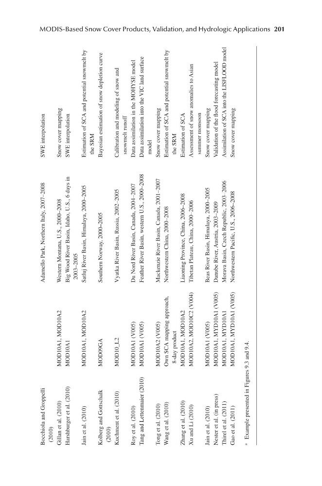
MODIS-Based Snow Cover Products, Validation, and Hydrologic Applications
Bocchiola and Groppelli
(2010)
Adamello Park, Northern Italy, 2007–2008
SWE interpolation
Gillan et al. (2010)
MOD10A1, MOD10A2
Western Montana, U.S., 2000–2008
Snow cover mapping
Harshburger et al. (2010)
MOD10A1
Big Wood River Basin, Idaho, U.S., 6 days in
2003–2005
SWE interpolation
Jain et al. (2010)
MOD10A1, MOD10A2
Satluj River Basin, Himalaya, 2000–2005
Estimation of SCA and potential snowmelt by
the SRM
Kolberg and Gottschalk
(2010)
MOD09GA
Southern Norway, 2000–2005
Bayesian estimation of snow depletion curve
Kuchment et al. (2010)
MOD10_L2
Vyatka River Basin, Russia, 2002–2005
Calibration and modeling of snow and
snowmelt runoff
Roy et al. (2010)
MOD10A1 (V005)
Du Nord River Basin, Canada, 2004–2007
Data assimilation in the MOHYSE model
Tang and Lettenmaier (2010)
MOD10A1 (V005)
Feather River Basin, western U.S., 2000–2008
Data assimilation into the VIC land surface
model
Tong et al. (2010)
MOD10A2 (V005)
Mackenzie River Basin, Canada, 2001–2007
Snow cover mapping
Wang et al. (2010)
Own SCA mapping approach,
8-day product
Northwestern China, 2000–2008
Estimation of SCA and potential snowmelt by
the SRM
Zhang et al. (2010)
MOD10A1, MOD10A2
Liaoning Province, China, 2006–2008
Estimation of SCA
Xu and Li (2010)
MOD10A2, MOD10C2 (V004)
Tibetan Plateau, China, 2000–2006
Assessment of snow anomalies to Asian
summer monsoon
Jain et al. (2010)
MOD10A1 (V005)
Beas River Basin, Himalaya, 2000–2005
Snow cover mapping
Nester et al. (in press)
MOD10A1, MYD10A1 (V005)
Danube River, Austria, 2003–2009
Validation of the flood forecasting model
Thirel et al. (2011)
MOD10A1, MYD10A1
Morava Basin, Czech Republic, 2003–2006
Assimilation of SCA into the LISFLOOD model
Gao et al. (2011)
MOD10A1, MYD10A1 (V005)
Northwestern Pacific, U.S., 2006–2008
Snow cover mapping
a
Example presented in Figures 9.3 and 9.4.