

200
Multiscale Hydrologic Remote Sensing: Perspectives and Applications
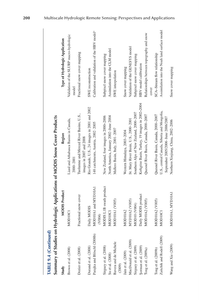
TABLE 9.4 (Continued)
Summary of Studies on Hydrologic Applications of MODIS Snow Cover Products
Study
MODIS Product
Region
Type of Hydrologic Application
Brown et al. (2008)
MOD10C1
Liard and Athabasca Basins in Canada,
2000–2001
Validation of the SLURP macro-hydrologic
model
Dozier et al. (2008)
Fractional snow cover
Tuolumne and Merced River Basins, U.S.,
images in 2007 and 2008
Fractional snow cover mapping
Durand et al. (2008)
Daily MODIS
Rio Grande, U.S., 24 images in 2001 and 2002
SWE reconstruction
Parajka and Blöschl (2008b)
MOD10A1 and MYD10A1
(V004)
148 catchments, Austria, 2002–2005
Calibration and validation of the HBV model a
Sirguey et al. (2008)
MODIS L1B swath product
New Zealand, four images in 2000–2006
Subpixel snow cover mapping
Su et al. (2008)
MOD10C1
North America, January 2002–June 2004
Assimilation into the CLM model
Bavera and de Michele
(2009)
MOD10A1 (V005)
Mallero Basin, Italy, 2001–2007
SWE interpolation
Jain et al. (2009)
MOD10A2
Western Himalaya, 2003–2004
Snow cover mapping
MacDonald et al. (2009)
MYD10A2 (V005)
St. Mary River Basin, U.S., 2000–2001
Validation of the GENESYS model
Sirguey et al. (2009)
MOD10 (V004)
Southern Alps of New Zealand, 2000–2007
Subpixel snow cover mapping
Şorman et al. (2009)
Daily MODIS product
Kırkgöze Basin, Turkey, 19 images in 2002–2004
HBV model calibration
Tong et al. (2009a)
MOD10A2 (V005)
Quesnel River Basin, Canada, 2000–2007
Relationships between topography and snow
cover
Tong et al. (2009b)
MOD10A2 (V005)
Quesnel River Basin, Canada, 2000–2007
SCA–Stream flow relationship
Zaitchik and Rodell (2009)
MOD10C1
U.S., central Canada, Siberia and Mongolia,
September 2005/2006–June 2006/2007
Assimilation into the Noah land surface model
Wang and Xie (2009)
MOD10A1, MYD10A1
Northern Xinjiang, China, 2002–2006
Snow cover mapping
Multiscale Hydrologic Remote Sensing: Perspectives and Applications
TABLE 9.4 (Continued)
Summary of Studies on Hydrologic Applications of MODIS Snow Cover Products
Study
MODIS Product
Region
Type of Hydrologic Application
Brown et al. (2008)
MOD10C1
Liard and Athabasca Basins in Canada,
2000–2001
Validation of the SLURP macro-hydrologic
model
Dozier et al. (2008)
Fractional snow cover
Tuolumne and Merced River Basins, U.S.,
images in 2007 and 2008
Fractional snow cover mapping
Durand et al. (2008)
Daily MODIS
Rio Grande, U.S., 24 images in 2001 and 2002
SWE reconstruction
Parajka and Blöschl (2008b)
MOD10A1 and MYD10A1
(V004)
148 catchments, Austria, 2002–2005
Calibration and validation of the HBV model a
Sirguey et al. (2008)
MODIS L1B swath product
New Zealand, four images in 2000–2006
Subpixel snow cover mapping
Su et al. (2008)
MOD10C1
North America, January 2002–June 2004
Assimilation into the CLM model
Bavera and de Michele
(2009)
MOD10A1 (V005)
Mallero Basin, Italy, 2001–2007
SWE interpolation
Jain et al. (2009)
MOD10A2
Western Himalaya, 2003–2004
Snow cover mapping
MacDonald et al. (2009)
MYD10A2 (V005)
St. Mary River Basin, U.S., 2000–2001
Validation of the GENESYS model
Sirguey et al. (2009)
MOD10 (V004)
Southern Alps of New Zealand, 2000–2007
Subpixel snow cover mapping
Şorman et al. (2009)
Daily MODIS product
Kırkgöze Basin, Turkey, 19 images in 2002–2004
HBV model calibration
Tong et al. (2009a)
MOD10A2 (V005)
Quesnel River Basin, Canada, 2000–2007
Relationships between topography and snow
cover
Tong et al. (2009b)
MOD10A2 (V005)
Quesnel River Basin, Canada, 2000–2007
SCA–Stream flow relationship
Zaitchik and Rodell (2009)
MOD10C1
U.S., central Canada, Siberia and Mongolia,
September 2005/2006–June 2006/2007
Assimilation into the Noah land surface model
Wang and Xie (2009)
MOD10A1, MYD10A1
Northern Xinjiang, China, 2002–2006
Snow cover mapping