

198
Multiscale Hydrologic Remote Sensing: Perspectives and Applications
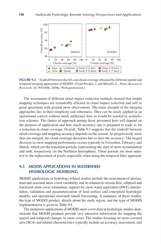
The assessment of different cloud impact reduction methods showed that simple
mapping techniques are remarkably efficient in cloud impact reduction and still in
good agreement with ground snow observations. The main strength of the merging
approaches lies in their simplicity and robustness. They can be easily applied in an
operational context without much additional data as would be needed in assimilation schemes. The choice of approach among those presented here will depend on
the purpose of application and how much accuracy one is prepared to trade in for
a reduction in cloud coverage. Overall, Table 9.3 suggests that the tradeoff between
cloud coverage and mapping accuracy depends on the season. As progressively more
data are merged, the cloud coverage decreases but so does the accuracy. The largest
decrease in snow mapping performance occurs typically in November, February, and
March, which are the transition periods, representing the start of snow accumulation
and melt, respectively (in the Northern hemisphere). These periods are most sensitive to the replacement of pixels, especially when using the temporal filter approach.
9.5 MODIS APPLICATIONS IN WATERSHED
HYDROLOGIC MODELING
MODIS applications in hydrology-related studies include the assessment of interannual and seasonal snow cover variability and its relation to stream flow, subpixel and
fractional snow cover estimation, support for snow water equivalent (SWE) interpolation, validation and parameterization of land surface and conceptual hydrologic
models, and operational snowmelt runoff forecasting. A summary of these studies,
the type of MODIS product, details about the study region, and the type of MODIS
implementation is given in Table 9.4.
The numerous applications of MODIS snow cover data in hydrologic studies demonstrate that MODIS products provide very attractive information for mapping the
spatial and temporal changes in snow cover. The studies focusing on snow-covered
area (SCA) and related characteristics typically include an accuracy assessment, and
0
20 40 60 80 100
Cloud coverage [%]
0
20 40 60 80 100
Cloud coverage [%]
80
85
90
95
100
Overall accuracy [%]
January
October
Aqua
Terra
Combined
Spatial
Temp. F. [1 day]
Temp. F. [3 days]
Temp. F. [5 days]
Temp. F. [7 days]
FIGURE 9.2 Tradeoff between the OA and cloud coverage obtained by different spatial and
temporal merging approaches of MODIS. (From Parajka, J. and Blöschl, G., Water Resources
Research, 44, W03406, 2008a. With permission.)
Multiscale Hydrologic Remote Sensing: Perspectives and Applications
The assessment of different cloud impact reduction methods showed that simple
mapping techniques are remarkably efficient in cloud impact reduction and still in
good agreement with ground snow observations. The main strength of the merging
approaches lies in their simplicity and robustness. They can be easily applied in an
operational context without much additional data as would be needed in assimilation schemes. The choice of approach among those presented here will depend on
the purpose of application and how much accuracy one is prepared to trade in for
a reduction in cloud coverage. Overall, Table 9.3 suggests that the tradeoff between
cloud coverage and mapping accuracy depends on the season. As progressively more
data are merged, the cloud coverage decreases but so does the accuracy. The largest
decrease in snow mapping performance occurs typically in November, February, and
March, which are the transition periods, representing the start of snow accumulation
and melt, respectively (in the Northern hemisphere). These periods are most sensitive to the replacement of pixels, especially when using the temporal filter approach.
9.5 MODIS APPLICATIONS IN WATERSHED
HYDROLOGIC MODELING
MODIS applications in hydrology-related studies include the assessment of interannual and seasonal snow cover variability and its relation to stream flow, subpixel and
fractional snow cover estimation, support for snow water equivalent (SWE) interpolation, validation and parameterization of land surface and conceptual hydrologic
models, and operational snowmelt runoff forecasting. A summary of these studies,
the type of MODIS product, details about the study region, and the type of MODIS
implementation is given in Table 9.4.
The numerous applications of MODIS snow cover data in hydrologic studies demonstrate that MODIS products provide very attractive information for mapping the
spatial and temporal changes in snow cover. The studies focusing on snow-covered
area (SCA) and related characteristics typically include an accuracy assessment, and
0
20 40 60 80 100
Cloud coverage [%]
0
20 40 60 80 100
Cloud coverage [%]
80
85
90
95
100
Overall accuracy [%]
January
October
Aqua
Terra
Combined
Spatial
Temp. F. [1 day]
Temp. F. [3 days]
Temp. F. [5 days]
Temp. F. [7 days]
FIGURE 9.2 Tradeoff between the OA and cloud coverage obtained by different spatial and
temporal merging approaches of MODIS. (From Parajka, J. and Blöschl, G., Water Resources
Research, 44, W03406, 2008a. With permission.)