

197
MODIS-Based Snow Cover Products, Validation, and Hydrologic Applications
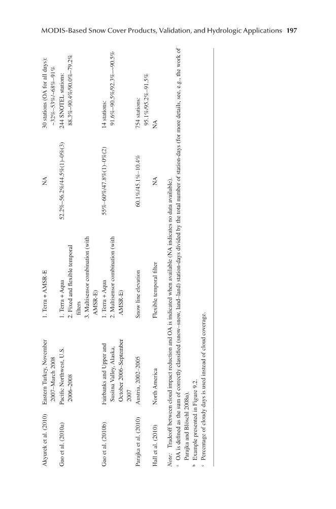
Akyurek et al. (2010) Eastern Turkey, November
2007–March 2008
1. Terra + AMSR-E
NA
30 stations (OA for all days):
~32%–53%/~68%–91%
Gao et al. (2010a)
Pacific Northwest, U.S.
2006–2008
1. Terra + Aqua
2. Fixed and flexible temporal
filters
3. Multisensor combination (with
AMSR-E)
52.2%–56.2%/44.5%(1)–0%(3)
244 SNOTEL stations:
88.3%–90.4%/90.0%–79.2%
Gao et al. (2010b)
Fairbanks and Upper and
Susitna Valley, Alaska,
October 2006–September
2007
1. Terra + Aqua
2. Multisensor combination (with
AMSR-E)
55%–60%/47.8%(1)–0%(2)
14 stations:
91.6%–90.5%/92.3%–~90.5%
Parajka et al. (2010)
Austria, 2002–2005
Snow line elevation
60.1%/45.1%–10.4%
754 stations:
95.1%/95.2%–91.5%
Hall et al. (2010)
North America
Flexible temporal filter
NA
NA
Note:
Tradeoff between cloud impact reduction and OA is indicated when available (NA indicates no data available).
a
OA is defined as the sum of correctly classified (snow–snow, land–land) station-days divided by the total number of station-days (for more details, see, e.g., the work of
Parajka and Blöschl 2008a).
b
Example presented in Figure 9.2.
c
Percentage of cloudy days is used instead of cloud coverage.
MODIS-Based Snow Cover Products, Validation, and Hydrologic Applications
Akyurek et al. (2010) Eastern Turkey, November
2007–March 2008
1. Terra + AMSR-E
NA
30 stations (OA for all days):
~32%–53%/~68%–91%
Gao et al. (2010a)
Pacific Northwest, U.S.
2006–2008
1. Terra + Aqua
2. Fixed and flexible temporal
filters
3. Multisensor combination (with
AMSR-E)
52.2%–56.2%/44.5%(1)–0%(3)
244 SNOTEL stations:
88.3%–90.4%/90.0%–79.2%
Gao et al. (2010b)
Fairbanks and Upper and
Susitna Valley, Alaska,
October 2006–September
2007
1. Terra + Aqua
2. Multisensor combination (with
AMSR-E)
55%–60%/47.8%(1)–0%(2)
14 stations:
91.6%–90.5%/92.3%–~90.5%
Parajka et al. (2010)
Austria, 2002–2005
Snow line elevation
60.1%/45.1%–10.4%
754 stations:
95.1%/95.2%–91.5%
Hall et al. (2010)
North America
Flexible temporal filter
NA
NA
Note:
Tradeoff between cloud impact reduction and OA is indicated when available (NA indicates no data available).
a
OA is defined as the sum of correctly classified (snow–snow, land–land) station-days divided by the total number of station-days (for more details, see, e.g., the work of
Parajka and Blöschl 2008a).
b
Example presented in Figure 9.2.
c
Percentage of cloudy days is used instead of cloud coverage.