

180
Multiscale Hydrologic Remote Sensing: Perspectives and Applications
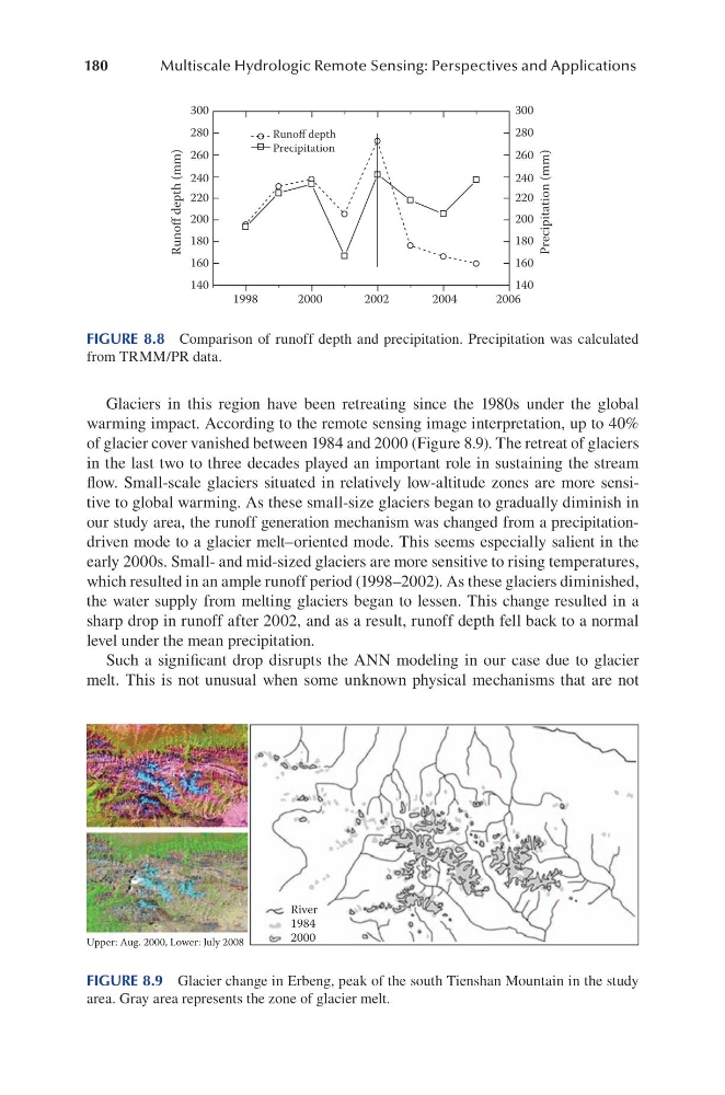
Glaciers in this region have been retreating since the 1980s under the global
warming impact. According to the remote sensing image interpretation, up to 40%
of glacier cover vanished between 1984 and 2000 (Figure 8.9). The retreat of glaciers
in the last two to three decades played an important role in sustaining the stream
flow. Small-scale glaciers situated in relatively low-altitude zones are more sensitive to global warming. As these small-size glaciers began to gradually diminish in
our study area, the runoff generation mechanism was changed from a precipitationdriven mode to a glacier melt–oriented mode. This seems especially salient in the
early 2000s. Small- and mid-sized glaciers are more sensitive to rising temperatures,
which resulted in an ample runoff period (1998–2002). As these glaciers diminished,
the water supply from melting glaciers began to lessen. This change resulted in a
sharp drop in runoff after 2002, and as a result, runoff depth fell back to a normal
level under the mean precipitation.
Such a significant drop disrupts the ANN modeling in our case due to glacier
melt. This is not unusual when some unknown physical mechanisms that are not
300
280
260
240
220
200
180
160
140
300
280
260
240
220
200
180
160
140
1998
2000
2002
2004
2006
Runoff depth (mm)
Precipitation (mm)
Runoff depth
Precipitation
FIGURE 8.8 Comparison of runoff depth and precipitation. Precipitation was calculated
from TRMM/PR data.
River
1984
2000
Upper: Aug. 2000, Lower: July 2008
FIGURE 8.9 Glacier change in Erbeng, peak of the south Tienshan Mountain in the study
area. Gray area represents the zone of glacier melt.
Multiscale Hydrologic Remote Sensing: Perspectives and Applications
Glaciers in this region have been retreating since the 1980s under the global
warming impact. According to the remote sensing image interpretation, up to 40%
of glacier cover vanished between 1984 and 2000 (Figure 8.9). The retreat of glaciers
in the last two to three decades played an important role in sustaining the stream
flow. Small-scale glaciers situated in relatively low-altitude zones are more sensitive to global warming. As these small-size glaciers began to gradually diminish in
our study area, the runoff generation mechanism was changed from a precipitationdriven mode to a glacier melt–oriented mode. This seems especially salient in the
early 2000s. Small- and mid-sized glaciers are more sensitive to rising temperatures,
which resulted in an ample runoff period (1998–2002). As these glaciers diminished,
the water supply from melting glaciers began to lessen. This change resulted in a
sharp drop in runoff after 2002, and as a result, runoff depth fell back to a normal
level under the mean precipitation.
Such a significant drop disrupts the ANN modeling in our case due to glacier
melt. This is not unusual when some unknown physical mechanisms that are not
300
280
260
240
220
200
180
160
140
300
280
260
240
220
200
180
160
140
1998
2000
2002
2004
2006
Runoff depth (mm)
Precipitation (mm)
Runoff depth
Precipitation
FIGURE 8.8 Comparison of runoff depth and precipitation. Precipitation was calculated
from TRMM/PR data.
River
1984
2000
Upper: Aug. 2000, Lower: July 2008
FIGURE 8.9 Glacier change in Erbeng, peak of the south Tienshan Mountain in the study
area. Gray area represents the zone of glacier melt.