

173
Modeling Stream Flow Changes
of some hydrologic variables. The question is how to use remotely sensed data to
foster the generation of hydrologic parameters as inputs to support predictive algorithms or operational models for estimating runoff. The satellite-derived precipitation products and LST data have been widely available over the past few years. In
this study, precipitation and LST are estimated with the aid of remotely sensed data.
The availability of TRMM/PR and MODIS/LST monthly data allows us to investigate precipitation and temperature changes at a much better spatial resolution, but
more efforts are still ongoing to evaluate the performances of algorithms used to
estimate precipitation (Marks et al. 2000), as well as to refine and validate MODIS/
LST (Wan 2008).
In this study, LST was selected as a substitute parameter for evaporation and
glacier melting. The MODIS/LST monthly data were composed from the daily
MOD11C1 product and were stored as the averaged values of clear-sky LSTs during a monthly period, beginning March 2000, in a 0.05° × 0.05° geographic climate
modeling grid. Besides, the TRMM/PR data (3B43 [V6]) have been available since
January 1998 in a 0.25° × 0.25° geographic grid. Because the validation of TRMM/
PR and MODIS/LST data was widely performed (Bowman 2005; Yatagai and Xie
2006), these grid data have been widely adopted for climate, hydrology, and ecosystem studies with spatial scales from mesolevel to macrolevel. With the image
TRMM/PR
images
MODIS/LST
images
Capture spatial structure
by EOF analysis
Training database
Output of results
Spatial variables
No
Is the
accuracy
acceptable?
Adaptive neural networks
Topology data
(DEM)
Yes
End
Hydrologic
data
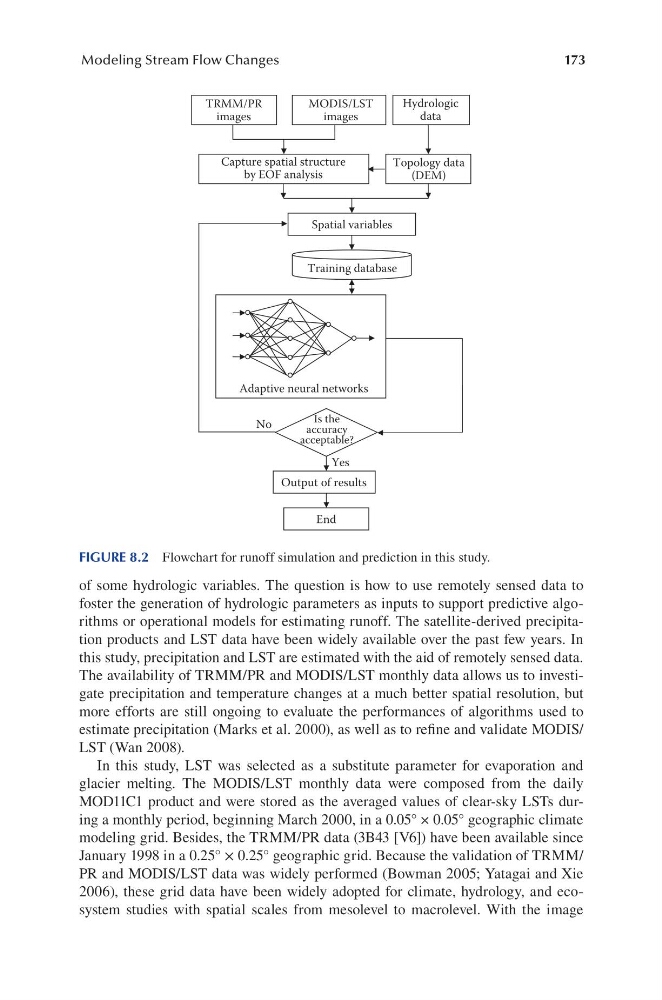
FIGURE 8.2 Flowchart for runoff simulation and prediction in this study.
Modeling Stream Flow Changes
of some hydrologic variables. The question is how to use remotely sensed data to
foster the generation of hydrologic parameters as inputs to support predictive algorithms or operational models for estimating runoff. The satellite-derived precipitation products and LST data have been widely available over the past few years. In
this study, precipitation and LST are estimated with the aid of remotely sensed data.
The availability of TRMM/PR and MODIS/LST monthly data allows us to investigate precipitation and temperature changes at a much better spatial resolution, but
more efforts are still ongoing to evaluate the performances of algorithms used to
estimate precipitation (Marks et al. 2000), as well as to refine and validate MODIS/
LST (Wan 2008).
In this study, LST was selected as a substitute parameter for evaporation and
glacier melting. The MODIS/LST monthly data were composed from the daily
MOD11C1 product and were stored as the averaged values of clear-sky LSTs during a monthly period, beginning March 2000, in a 0.05° × 0.05° geographic climate
modeling grid. Besides, the TRMM/PR data (3B43 [V6]) have been available since
January 1998 in a 0.25° × 0.25° geographic grid. Because the validation of TRMM/
PR and MODIS/LST data was widely performed (Bowman 2005; Yatagai and Xie
2006), these grid data have been widely adopted for climate, hydrology, and ecosystem studies with spatial scales from mesolevel to macrolevel. With the image
TRMM/PR
images
MODIS/LST
images
Capture spatial structure
by EOF analysis
Training database
Output of results
Spatial variables
No
Is the
accuracy
acceptable?
Adaptive neural networks
Topology data
(DEM)
Yes
End
Hydrologic
data
FIGURE 8.2 Flowchart for runoff simulation and prediction in this study.