

144
Multiscale Hydrologic Remote Sensing: Perspectives and Applications
collected by the Shuttle Radar Topography Mission (SRTM) were applied; the available DEM data in this study are SRTM3 with a 90-m resolution. The climate data
were collected from the National Meteorological Center of China Weather Bureau.
The spectrum of climate data includes average temperature, maximum temperature, minimum temperature, precipitation, average wind speed, and amount of cloud
cover, among others. All data sets were vectorized and interpolated as grid data
sets with the universal transverse mercator (UTM) projection in advance to ease the
application in a geographical information system.
Noise reduction is necessary for remotely sensed images, especially for the thermal infrared band. Noise may affect the retrieval of LST, sensible heat flux, and
latent heat flux. There is periodic noise (e.g., stripes in the TM/band 6) and nonperiodic noise (e.g., speckles). In this study, a self-adaptive filter method was used to
remove nonperiodic noise, and the fast Fourier transform method was used to automatically remove periodic noise; both were performed with the ERDAS IMAGINE
software. The unreferenced images were then rectified and georeferenced by a set
of characteristic ground points. To analyze spatiotemporal changes in the LULC of
our study area at the 1:100,000 scale, multitemporal images must be coregistered
in the same coordinate system (e.g., UTM/WGS84). In this study, the raw images
were georeferenced to a common UTM coordinate system, and we then resampled
all images to unify relative resolution in images of different sizes using the nearest
neighbor algorithm with a pixel size of 30 m × 30 m. This adjustment was carried out
0 30 60
120
160
240
km
N
W
E
S
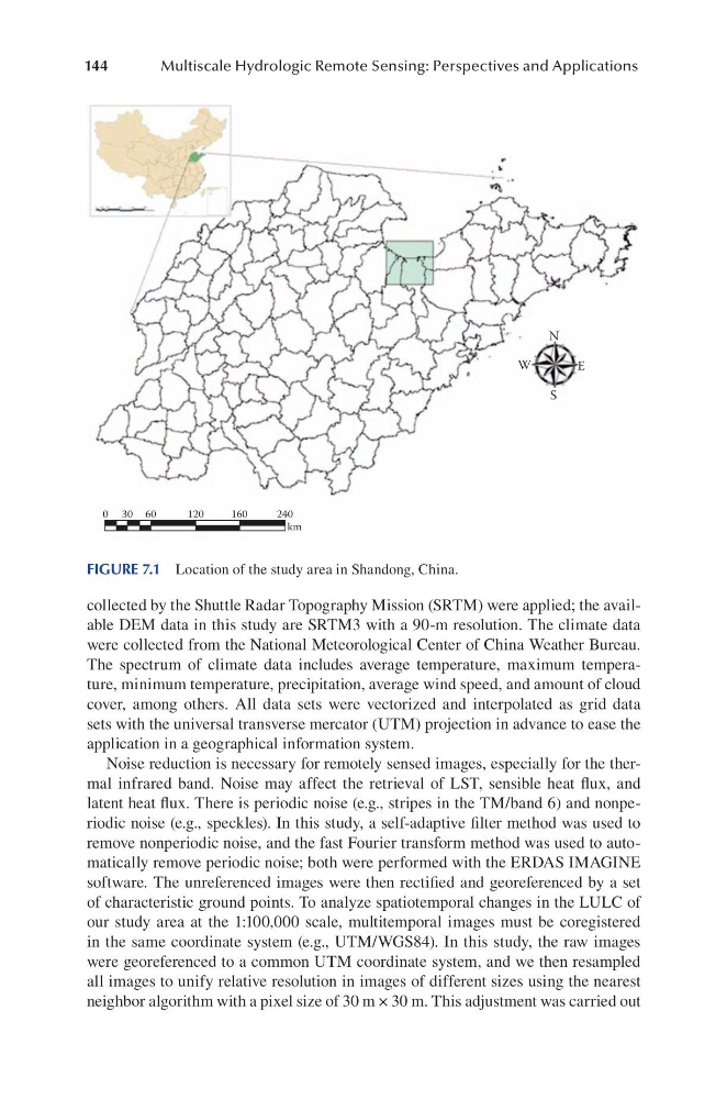
FIGURE 7.1 Location of the study area in Shandong, China.
Multiscale Hydrologic Remote Sensing: Perspectives and Applications
collected by the Shuttle Radar Topography Mission (SRTM) were applied; the available DEM data in this study are SRTM3 with a 90-m resolution. The climate data
were collected from the National Meteorological Center of China Weather Bureau.
The spectrum of climate data includes average temperature, maximum temperature, minimum temperature, precipitation, average wind speed, and amount of cloud
cover, among others. All data sets were vectorized and interpolated as grid data
sets with the universal transverse mercator (UTM) projection in advance to ease the
application in a geographical information system.
Noise reduction is necessary for remotely sensed images, especially for the thermal infrared band. Noise may affect the retrieval of LST, sensible heat flux, and
latent heat flux. There is periodic noise (e.g., stripes in the TM/band 6) and nonperiodic noise (e.g., speckles). In this study, a self-adaptive filter method was used to
remove nonperiodic noise, and the fast Fourier transform method was used to automatically remove periodic noise; both were performed with the ERDAS IMAGINE
software. The unreferenced images were then rectified and georeferenced by a set
of characteristic ground points. To analyze spatiotemporal changes in the LULC of
our study area at the 1:100,000 scale, multitemporal images must be coregistered
in the same coordinate system (e.g., UTM/WGS84). In this study, the raw images
were georeferenced to a common UTM coordinate system, and we then resampled
all images to unify relative resolution in images of different sizes using the nearest
neighbor algorithm with a pixel size of 30 m × 30 m. This adjustment was carried out
0 30 60
120
160
240
km
N
W
E
S
FIGURE 7.1 Location of the study area in Shandong, China.