

short summers (see Fig. 5.2, climate diagram for
Jakutsk, Siberia). Only 1 month of the year has
an average temperature above 10
C.
Winter is the dominant season of the boreal
subarctic climate. Because average monthly
temperatures are subfreezing for six to seven
consecutive months, all moisture in the soil and
subsoil freezes solidly to depths of a few meters.
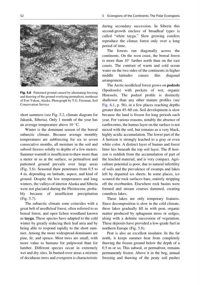
Summer warmth is insufficient to thaw more than
a meter or so at the surface, so permafrost and
patterned ground prevails over large areas
(Fig. 5.6). Seasonal thaw penetrates from 0.5 to
4 m, depending on latitude, aspect, and kind of
ground. Despite the low temperatures and long
winters, the valleys of interior Alaska and Siberia
were not glaciated during the Pleistocene, probably because of insufficient precipitation
(Fig. 5.7).
The subarctic climate zone coincides with a
great belt of needleleaf forest, often referred to as
boreal forest, and open lichen woodland known
as tayga. These species have adapted to the cold
winter by greatly reducing their leaf area and by
being able to respond rapidly to the short summer. Among the more widespread dominants are
pine, fir, and spruce. Most trees are small, with
more value to humans for pulpwood than for
lumber. Different species occur in extremely
wet and dry sites. In burned-over areas a mixture
of deciduous trees and evergreen is characteristic
during secondary succession. In Siberia this
second-growth enclave of broadleaf types is
called “white tayga.” Slow growing conifers
reproduce the climax forest only over a long
period of time.
The forests run diagonally across the
continents. On the west coast, the boreal forest
is more than 10
farther north than on the east
coasts. The contrast of warm and cold ocean
water on the two sides of the continents in higher
middle latitudes causes this diagonal
arrangement.
The Arctic needleleaf forest grows on podzols
(Spodosols) with pockets of wet, organic
Histosols. The podzol profile is distinctly
shallower than any other mature profiles (see
Fig. 6.1, p. 56), in a few places reaching depths
greater then 45–60 cm. Soil development is slow
because the land is frozen for long periods each
year. For various reasons, notably the absence of
earthworms, the humus layer on the surface is not
mixed with the soil, but remains as a very black,
highly acidic accumulation. The lower part of the
A horizon is strongly leached to a gray or even
white color. A distinct layer of humus and forest
litter lies beneath the top soil layer. The B horizon is reddish from the accumulation of part of
the leached material, and is very compact. Agriculture potential is poor, due to natural infertility
of soils and the prevalence of swamps and lakes
left by departed ice sheets. In some places, ice
scoured the rock surfaces bare, entirely stripping
off the overburden. Elsewhere rock basins were
formed and stream courses dammed, creating
countless lakes.
These lakes are only temporary features.
Since decomposition is slow in the cold climate,
these lakes gradually fill in with peat, organic
matter produced by sphagnum moss or sedges,
along with a definite succession of vegetation.
These deposits have provided a low-grade fuel in
northern Europe (Fig. 5.8).
Peat is also an excellent insulator. In the far
north, it keeps summer heat from completely
thawing the frozen ground below the depth of a
0.5 m or so. This subsoil, or permafrost, remains
permanently frozen. Above it in the bog, annual
freezing and thawing of the peaty soil pushes
Fig. 5.6 Patterned ground caused by alternating freezing
and thawing of the ground overlying permafrost, northeast
of Fort Yukon, Alaska. Photograph by T.G. Freeman, Soil
Conservation Service
52
5 Ecoregions of the Continents: The Polar Ecoregions
Jakutsk, Siberia). Only 1 month of the year has
an average temperature above 10
C.
Winter is the dominant season of the boreal
subarctic climate. Because average monthly
temperatures are subfreezing for six to seven
consecutive months, all moisture in the soil and
subsoil freezes solidly to depths of a few meters.
Summer warmth is insufficient to thaw more than
a meter or so at the surface, so permafrost and
patterned ground prevails over large areas
(Fig. 5.6). Seasonal thaw penetrates from 0.5 to
4 m, depending on latitude, aspect, and kind of
ground. Despite the low temperatures and long
winters, the valleys of interior Alaska and Siberia
were not glaciated during the Pleistocene, probably because of insufficient precipitation
(Fig. 5.7).
The subarctic climate zone coincides with a
great belt of needleleaf forest, often referred to as
boreal forest, and open lichen woodland known
as tayga. These species have adapted to the cold
winter by greatly reducing their leaf area and by
being able to respond rapidly to the short summer. Among the more widespread dominants are
pine, fir, and spruce. Most trees are small, with
more value to humans for pulpwood than for
lumber. Different species occur in extremely
wet and dry sites. In burned-over areas a mixture
of deciduous trees and evergreen is characteristic
during secondary succession. In Siberia this
second-growth enclave of broadleaf types is
called “white tayga.” Slow growing conifers
reproduce the climax forest only over a long
period of time.
The forests run diagonally across the
continents. On the west coast, the boreal forest
is more than 10
farther north than on the east
coasts. The contrast of warm and cold ocean
water on the two sides of the continents in higher
middle latitudes causes this diagonal
arrangement.
The Arctic needleleaf forest grows on podzols
(Spodosols) with pockets of wet, organic
Histosols. The podzol profile is distinctly
shallower than any other mature profiles (see
Fig. 6.1, p. 56), in a few places reaching depths
greater then 45–60 cm. Soil development is slow
because the land is frozen for long periods each
year. For various reasons, notably the absence of
earthworms, the humus layer on the surface is not
mixed with the soil, but remains as a very black,
highly acidic accumulation. The lower part of the
A horizon is strongly leached to a gray or even
white color. A distinct layer of humus and forest
litter lies beneath the top soil layer. The B horizon is reddish from the accumulation of part of
the leached material, and is very compact. Agriculture potential is poor, due to natural infertility
of soils and the prevalence of swamps and lakes
left by departed ice sheets. In some places, ice
scoured the rock surfaces bare, entirely stripping
off the overburden. Elsewhere rock basins were
formed and stream courses dammed, creating
countless lakes.
These lakes are only temporary features.
Since decomposition is slow in the cold climate,
these lakes gradually fill in with peat, organic
matter produced by sphagnum moss or sedges,
along with a definite succession of vegetation.
These deposits have provided a low-grade fuel in
northern Europe (Fig. 5.8).
Peat is also an excellent insulator. In the far
north, it keeps summer heat from completely
thawing the frozen ground below the depth of a
0.5 m or so. This subsoil, or permafrost, remains
permanently frozen. Above it in the bog, annual
freezing and thawing of the peaty soil pushes
Fig. 5.6 Patterned ground caused by alternating freezing
and thawing of the ground overlying permafrost, northeast
of Fort Yukon, Alaska. Photograph by T.G. Freeman, Soil
Conservation Service
52
5 Ecoregions of the Continents: The Polar Ecoregions