

irregularity which relates to all those features
associated with land surface forms. The principle
of regularity allows us to forecast the kinds of
associated features that can be expected at any
given latitude and longitudinal position. However, irregularities distort these regular patterns
on each specific continent.
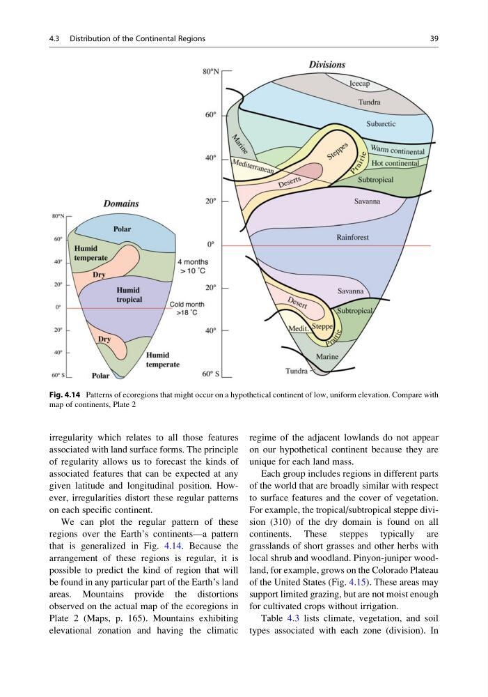
We can plot the regular pattern of these
regions over the Earth’s continents—a pattern
that is generalized in Fig. 4.14. Because the
arrangement of these regions is regular, it is
possible to predict the kind of region that will
be found in any particular part of the Earth’s land
areas. Mountains provide the distortions
observed on the actual map of the ecoregions in
Plate 2 (Maps, p. 165). Mountains exhibiting
elevational zonation and having the climatic
regime of the adjacent lowlands do not appear
on our hypothetical continent because they are
unique for each land mass.
Each group includes regions in different parts
of the world that are broadly similar with respect
to surface features and the cover of vegetation.
For example, the tropical/subtropical steppe division (310) of the dry domain is found on all
continents. These steppes typically are
grasslands of short grasses and other herbs with
local shrub and woodland. Pinyon-juniper woodland, for example, grows on the Colorado Plateau
of the United States (Fig. 4.15). These areas may
support limited grazing, but are not moist enough
for cultivated crops without irrigation.
Table 4.3 lists climate, vegetation, and soil
types associated with each zone (division). In
Fig. 4.14 Patterns of ecoregions that might occur on a hypothetical continent of low, uniform elevation. Compare with
map of continents, Plate 2
4.3 Distribution of the Continental Regions
39
associated with land surface forms. The principle
of regularity allows us to forecast the kinds of
associated features that can be expected at any
given latitude and longitudinal position. However, irregularities distort these regular patterns
on each specific continent.
We can plot the regular pattern of these
regions over the Earth’s continents—a pattern
that is generalized in Fig. 4.14. Because the
arrangement of these regions is regular, it is
possible to predict the kind of region that will
be found in any particular part of the Earth’s land
areas. Mountains provide the distortions
observed on the actual map of the ecoregions in
Plate 2 (Maps, p. 165). Mountains exhibiting
elevational zonation and having the climatic
regime of the adjacent lowlands do not appear
on our hypothetical continent because they are
unique for each land mass.
Each group includes regions in different parts
of the world that are broadly similar with respect
to surface features and the cover of vegetation.
For example, the tropical/subtropical steppe division (310) of the dry domain is found on all
continents. These steppes typically are
grasslands of short grasses and other herbs with
local shrub and woodland. Pinyon-juniper woodland, for example, grows on the Colorado Plateau
of the United States (Fig. 4.15). These areas may
support limited grazing, but are not moist enough
for cultivated crops without irrigation.
Table 4.3 lists climate, vegetation, and soil
types associated with each zone (division). In
Fig. 4.14 Patterns of ecoregions that might occur on a hypothetical continent of low, uniform elevation. Compare with
map of continents, Plate 2
4.3 Distribution of the Continental Regions
39