

human intervention should be removed. This is
known as potential natural vegetation (Ku ¨chler
1964).
4.1.3 Modified by Elevation
The arrangement of the ecological zones is
largely dependent on latitude. To further complicate matters, the Earth’s internal energy causes
irregular patterns of high mountains on the
continents (Fig. 4.9). These modify and distort
the simple climatic pattern that would develop
on a flat continent. We can see the short-term
and small-scale implications of this difference in
local meteorological boundary effects (Fig. 4.10).
These mountains are arranged without
conforming at all to the orderly latitudinal zones
of climate. They cut irregularly across latitudinally oriented climatic zones. For example, we
find mountains in the cold deserts of Antarctica as
well as near the equator (Fig. 4.11). The regions
of this type do not appear on the diagram showing
the generalized global pattern of ecoregions (see
Fig. 4.14, p. 39) because these features, along
with the outlines of the continents, are unique
for each land mass.
Mountains have a typical sequence of
elevational belts, with different ecosystems at
successive levels (Fig. 4.12). These differ
according to the zone in which the mountain is
embedded. In other words, elevation produces a
predictable variation of the lowland climate,
especially in climatic regime (i.e., seasonality
of temperature and precipitation). The coast
ranges of California, for example, experience
the same strong seasonal energy variations, and
a seasonal moisture regime consisting of a dry
summer and a rainy winter typical of their neighboring lowlands.
When a mountain occurs in two climatic
zones, it produces different vertical zonation
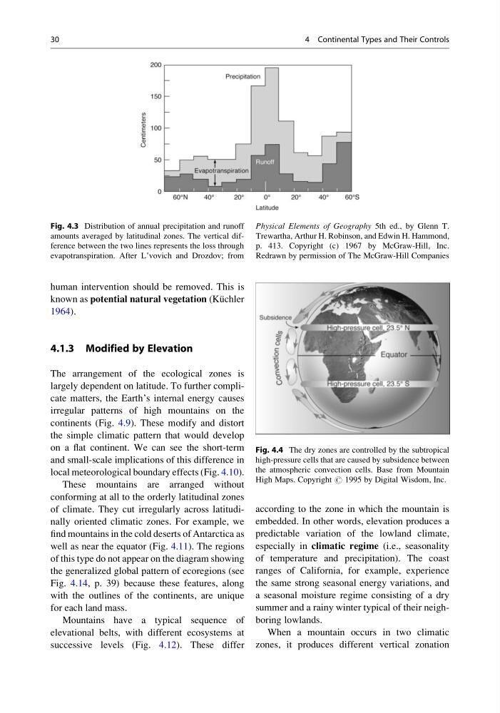
Fig. 4.3 Distribution of annual precipitation and runoff
amounts averaged by latitudinal zones. The vertical difference between the two lines represents the loss through
evapotranspiration. After L’vovich and Drozdov; from
Physical Elements of Geography 5th ed., by Glenn T.
Trewartha, Arthur H. Robinson, and Edwin H. Hammond,
p. 413. Copyright (c) 1967 by McGraw-Hill, Inc.
Redrawn by permission of The McGraw-Hill Companies
Fig. 4.4 The dry zones are controlled by the subtropical
high-pressure cells that are caused by subsidence between
the atmospheric convection cells. Base from Mountain
High Maps. Copyright # 1995 by Digital Wisdom, Inc.
30
4 Continental Types and Their Controls
known as potential natural vegetation (Ku ¨chler
1964).
4.1.3 Modified by Elevation
The arrangement of the ecological zones is
largely dependent on latitude. To further complicate matters, the Earth’s internal energy causes
irregular patterns of high mountains on the
continents (Fig. 4.9). These modify and distort
the simple climatic pattern that would develop
on a flat continent. We can see the short-term
and small-scale implications of this difference in
local meteorological boundary effects (Fig. 4.10).
These mountains are arranged without
conforming at all to the orderly latitudinal zones
of climate. They cut irregularly across latitudinally oriented climatic zones. For example, we
find mountains in the cold deserts of Antarctica as
well as near the equator (Fig. 4.11). The regions
of this type do not appear on the diagram showing
the generalized global pattern of ecoregions (see
Fig. 4.14, p. 39) because these features, along
with the outlines of the continents, are unique
for each land mass.
Mountains have a typical sequence of
elevational belts, with different ecosystems at
successive levels (Fig. 4.12). These differ
according to the zone in which the mountain is
embedded. In other words, elevation produces a
predictable variation of the lowland climate,
especially in climatic regime (i.e., seasonality
of temperature and precipitation). The coast
ranges of California, for example, experience
the same strong seasonal energy variations, and
a seasonal moisture regime consisting of a dry
summer and a rainy winter typical of their neighboring lowlands.
When a mountain occurs in two climatic
zones, it produces different vertical zonation
Fig. 4.3 Distribution of annual precipitation and runoff
amounts averaged by latitudinal zones. The vertical difference between the two lines represents the loss through
evapotranspiration. After L’vovich and Drozdov; from
Physical Elements of Geography 5th ed., by Glenn T.
Trewartha, Arthur H. Robinson, and Edwin H. Hammond,
p. 413. Copyright (c) 1967 by McGraw-Hill, Inc.
Redrawn by permission of The McGraw-Hill Companies
Fig. 4.4 The dry zones are controlled by the subtropical
high-pressure cells that are caused by subsidence between
the atmospheric convection cells. Base from Mountain
High Maps. Copyright # 1995 by Digital Wisdom, Inc.
30
4 Continental Types and Their Controls