

areas with high risk. This helps government
agencies better plan for wildfire hazards. They
can also be used as a baseline from which to
assess natural fire regimes, and these assessments
can be used to abate the threat of fire exclusion
and restore fire-adapted ecosystems. In fact,
these baseline reference conditions are currently
being developed as part of the LANDFIRE project (http://www.landfire.gov) by the US Forest
Service (Missoula Fire Sciences Laboratory), the
US Geological Survey (EROS Data Center), and
The Nature Conservancy for all biophysical system across the United States. In addition, understanding fire regimes at the ecoregion scale can
provide valuable insights important for designing
fuel treatments by helping to determine highhazard from low-hazard situations.
Finally, what can be done to reduce the risk of
fire? Savage (2003) and Allen et al. (2002)
suggest several principles to guide the implementation of ecologically justifiable restoration
projects. Two of the most important ones are:
1. Restoration of natural fire regimes (e.g., in
southwestern ponderosa pine forests reduce
the widespread risk of crown fires by return
to low-intensity surface fire).
2. Pay attention to both structure and process
(e.g., thinning young trees to reduce the fuel
load may not work unless low-intensity surface fires are also reintroduced).
Analysis of the literature to date strongly
indicates that thinning or burning treatments, or
both together, do have effects consistent with
restoring low-severity fire behavior in western
United States pine forests (Fule et al. 2012).
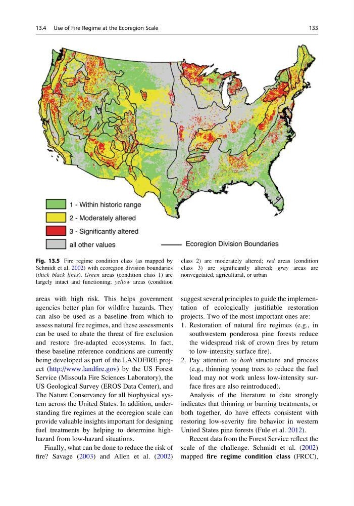
Recent data from the Forest Service reflect the
scale of the challenge. Schmidt et al. (2002)
mapped fire regime condition class (FRCC),
Fig. 13.5 Fire regime condition class (as mapped by
Schmidt et al. 2002) with ecoregion division boundaries
(thick black lines). Green areas (condition class 1) are
largely intact and functioning; yellow areas (condition
class 2) are moderately altered; red areas (condition
class 3) are significantly altered; gray areas are
nonvegetated, agricultural, or urban
13.4 Use of Fire Regime at the Ecoregion Scale
133
agencies better plan for wildfire hazards. They
can also be used as a baseline from which to
assess natural fire regimes, and these assessments
can be used to abate the threat of fire exclusion
and restore fire-adapted ecosystems. In fact,
these baseline reference conditions are currently
being developed as part of the LANDFIRE project (http://www.landfire.gov) by the US Forest
Service (Missoula Fire Sciences Laboratory), the
US Geological Survey (EROS Data Center), and
The Nature Conservancy for all biophysical system across the United States. In addition, understanding fire regimes at the ecoregion scale can
provide valuable insights important for designing
fuel treatments by helping to determine highhazard from low-hazard situations.
Finally, what can be done to reduce the risk of
fire? Savage (2003) and Allen et al. (2002)
suggest several principles to guide the implementation of ecologically justifiable restoration
projects. Two of the most important ones are:
1. Restoration of natural fire regimes (e.g., in
southwestern ponderosa pine forests reduce
the widespread risk of crown fires by return
to low-intensity surface fire).
2. Pay attention to both structure and process
(e.g., thinning young trees to reduce the fuel
load may not work unless low-intensity surface fires are also reintroduced).
Analysis of the literature to date strongly
indicates that thinning or burning treatments, or
both together, do have effects consistent with
restoring low-severity fire behavior in western
United States pine forests (Fule et al. 2012).
Recent data from the Forest Service reflect the
scale of the challenge. Schmidt et al. (2002)
mapped fire regime condition class (FRCC),
Fig. 13.5 Fire regime condition class (as mapped by
Schmidt et al. 2002) with ecoregion division boundaries
(thick black lines). Green areas (condition class 1) are
largely intact and functioning; yellow areas (condition
class 2) are moderately altered; red areas (condition
class 3) are significantly altered; gray areas are
nonvegetated, agricultural, or urban
13.4 Use of Fire Regime at the Ecoregion Scale
133