

284 Resources from the Ocean Floor
is too young and the sediment carpet is too thin (Fig. 10.5). The most promising
prospects for petroleum concentrations are continental shelves and slopes, and small
ocean basins with thick sediments produced by high accumulation rates and which
are rich in organic matter (e. g., the Gulf of Mexico, the Caribbean, the Mediterranean including the Black Sea, the Bering Sea, Okhotsk, Japan, South China Seas,
and the Indonesian Archipelago). The enormous sediment wedges of the continental
rises bordering the large ocean basins, although rich in organic matter in places, may
or may not contain suitable reservoir rocks; this question is being explored.
The shelf off the US East Coast has become the site of intensive exploration, and
leases have been granted in places, after much opposition from citizen's groups
concerned about the possibility of oil pollution. As shown by occurrences off California (Santa Barbara oil spill, 1969), in the North Sea (Ekofisk oil spill 1977), or in the
Gulf of Mexico (lxtoc-I oil spill 1979), such concern is not without basis. The
problem is a political one of profit and risk distribution; effects of spills on the ocean
as a whole cannot be shown to be damaging (but neither is it known whether spills
are innocuous). Regional damage, of course, can be extensive.
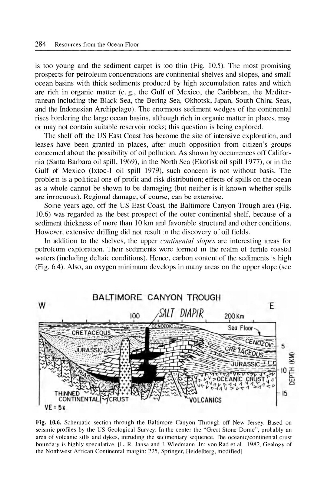
Some years ago, off the US East Coast, the Baltimore Canyon Trough area (Fig.
10.6) was regarded as the best prospect of the outer continental shelf, because of a
sediment thickness of more than 10 km and favorable structural and other conditions.
However, extensive drilling did not result in the discovery of oil fields .
In addition to the shelves, the upper continental slopes are interesting areas for
petroleum exploration. Their sediments were formed in the realm of fertile coastal
waters (including deltaic conditions). Hence, carbon content of the sediments is high
(Fig. 6.4). Also, an oxygen minimum develops in many areas on the upper slope (see
BALTIMORE CANYON TROUGH
w
T DIAPIR
E
100
200Km
5
15
Fig. 10.6. Schematic section through the Baltimore Canyon Through off New Jersey. Based on
seismic profiles by the US Geological Survey. In the center the "Great Stone Dome", probably an
area of volcanic sills and dykes , intruding the sedimentary sequence. The oceanic/continental crust
boundary is highly speculative. [L. R. Jansa and J. Wiedmann. In: von Rad et aI. , 1982, Geology of
the Northwest African Continental margin: 225, Springer, Heidelberg, modified]
is too young and the sediment carpet is too thin (Fig. 10.5). The most promising
prospects for petroleum concentrations are continental shelves and slopes, and small
ocean basins with thick sediments produced by high accumulation rates and which
are rich in organic matter (e. g., the Gulf of Mexico, the Caribbean, the Mediterranean including the Black Sea, the Bering Sea, Okhotsk, Japan, South China Seas,
and the Indonesian Archipelago). The enormous sediment wedges of the continental
rises bordering the large ocean basins, although rich in organic matter in places, may
or may not contain suitable reservoir rocks; this question is being explored.
The shelf off the US East Coast has become the site of intensive exploration, and
leases have been granted in places, after much opposition from citizen's groups
concerned about the possibility of oil pollution. As shown by occurrences off California (Santa Barbara oil spill, 1969), in the North Sea (Ekofisk oil spill 1977), or in the
Gulf of Mexico (lxtoc-I oil spill 1979), such concern is not without basis. The
problem is a political one of profit and risk distribution; effects of spills on the ocean
as a whole cannot be shown to be damaging (but neither is it known whether spills
are innocuous). Regional damage, of course, can be extensive.
Some years ago, off the US East Coast, the Baltimore Canyon Trough area (Fig.
10.6) was regarded as the best prospect of the outer continental shelf, because of a
sediment thickness of more than 10 km and favorable structural and other conditions.
However, extensive drilling did not result in the discovery of oil fields .
In addition to the shelves, the upper continental slopes are interesting areas for
petroleum exploration. Their sediments were formed in the realm of fertile coastal
waters (including deltaic conditions). Hence, carbon content of the sediments is high
(Fig. 6.4). Also, an oxygen minimum develops in many areas on the upper slope (see
BALTIMORE CANYON TROUGH
w
T DIAPIR
E
100
200Km
5
15
Fig. 10.6. Schematic section through the Baltimore Canyon Through off New Jersey. Based on
seismic profiles by the US Geological Survey. In the center the "Great Stone Dome", probably an
area of volcanic sills and dykes , intruding the sedimentary sequence. The oceanic/continental crust
boundary is highly speculative. [L. R. Jansa and J. Wiedmann. In: von Rad et aI. , 1982, Geology of
the Northwest African Continental margin: 225, Springer, Heidelberg, modified]