

10 Introduction
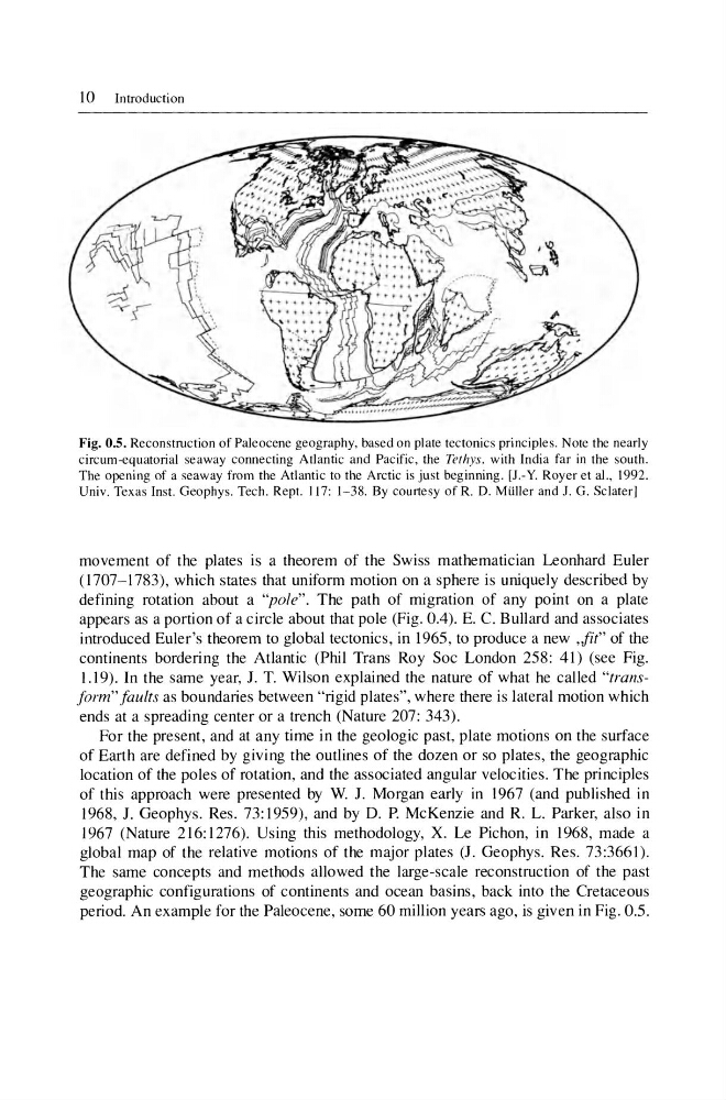
Fig. 0.5. Reconstruction of Paleocene geography, based on plate tectonics principle s. Note the nearly
circum-equatorial seaway connecting Atlantic and Pacific , the Tethys. with India far in the south.
The opening of a seaway from the Atlantic 10 the Arctic is just beginning . [1.- Y. Royer et aI., 1992.
Univ. Texas Inst. Geophys. Tech . Rept. 1l7: 1- 38. By courtesy of R. D. MUller and J. G. Sclaterl
movement of the plates is a theorem of the Swiss mathematician Leonhard Euler
(1707-1783), which states that uniform motion on a sphere is uniquely described by
defining rotation about a "pole". The path of migration of any point on a plate
appears as a portion of a circle about that pole (Fig. 0.4). E. C. Bullard and associates
introduced Euler's theorem to global tectonics, in 1965, to produce a new ,fit" of the
continents bordering the Atlantic (Phil Trans Roy Soc London 258: 4 I) (see Fig.
J.I 9). In the same year, 1. T. Wilson explained the nature of what he called "transform" faults as boundaries between "rigid plates", where there is lateral motion which
ends at a spreading center or a trench (Nature 207: 343).
For the present, and at any time in the geologic past, plate motions on the surface
of Earth are defined by giving the outlines of the dozen or so plates, the geographic
location of the poles of rotation, and the associated angular velocities. The principles
of this approach were presented by W. 1. Morgan early in 1967 (and published in
1968,1. Geophys. Res. 73:1959), and by D. P. McKenzie and R. L. Parker, also in
1967 (Nature 2 16: 1276). Using this methodology, X. Le Pichon, in 1968, made a
global map of the relative motions of the major plates (J. Geophys. Res . 73:3661).
The same concepts and methods allowed the large-scale reconstruction of the past
geographic configurations of continents and ocean basins, back into the Cretaceous
period. An example for the Paleocene, some 60 million years ago, is given in Fig. 0.5 .
Fig. 0.5. Reconstruction of Paleocene geography, based on plate tectonics principle s. Note the nearly
circum-equatorial seaway connecting Atlantic and Pacific , the Tethys. with India far in the south.
The opening of a seaway from the Atlantic 10 the Arctic is just beginning . [1.- Y. Royer et aI., 1992.
Univ. Texas Inst. Geophys. Tech . Rept. 1l7: 1- 38. By courtesy of R. D. MUller and J. G. Sclaterl
movement of the plates is a theorem of the Swiss mathematician Leonhard Euler
(1707-1783), which states that uniform motion on a sphere is uniquely described by
defining rotation about a "pole". The path of migration of any point on a plate
appears as a portion of a circle about that pole (Fig. 0.4). E. C. Bullard and associates
introduced Euler's theorem to global tectonics, in 1965, to produce a new ,fit" of the
continents bordering the Atlantic (Phil Trans Roy Soc London 258: 4 I) (see Fig.
J.I 9). In the same year, 1. T. Wilson explained the nature of what he called "transform" faults as boundaries between "rigid plates", where there is lateral motion which
ends at a spreading center or a trench (Nature 207: 343).
For the present, and at any time in the geologic past, plate motions on the surface
of Earth are defined by giving the outlines of the dozen or so plates, the geographic
location of the poles of rotation, and the associated angular velocities. The principles
of this approach were presented by W. 1. Morgan early in 1967 (and published in
1968,1. Geophys. Res. 73:1959), and by D. P. McKenzie and R. L. Parker, also in
1967 (Nature 2 16: 1276). Using this methodology, X. Le Pichon, in 1968, made a
global map of the relative motions of the major plates (J. Geophys. Res . 73:3661).
The same concepts and methods allowed the large-scale reconstruction of the past
geographic configurations of continents and ocean basins, back into the Cretaceous
period. An example for the Paleocene, some 60 million years ago, is given in Fig. 0.5 .