

o
I
Chioggia
Sea Level and the Fate of Venice
153
20km
I
Venice
A
\ /
Marghera
o
-'10..
/
50
r
r lUI
1)0
B
C
Treviso 0
~~~~-------qH-----~100
L-__ ~ ______________ ~ ________ ~mm
o •
B
E
3
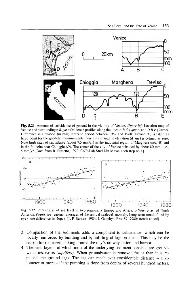
Fig. 5.21. Amount of subsidence of ground in the vicinity of Venice. Upper left Location map of
Venice and surroundings; Right subsidence profiles along the lines ABC (upper) and D BE (lower) .
Difference in elevation (in mm) refers to period between 1952 and 1968. Treviso (E) is taken as
fixed point for the geodetic measurements; hence its change in elevation (i f any) is defined as zero.
Note high rates of subsidence (about 7.5 mm/yr) in the industrial region of Marghera (near B) and
in the Po delta near Chioggia (D). The center of the city of Venice subsided by about 80 mm , i. e. ,
5 mm/yr. [Data from R. Fraselto, 1972, CNR-Lab Stud Din Masse Tech Rep no 4].
a
b
' ..
-20)L..t......L..J.-LL...L...J--l.--'-'-'-.L..LO-'---'----'-"-1-'= 9~ 8~0
1900
194
1900
1940
1980
Fig. 5.22. Recent rise of sea level in two regions. a Europe and Africa. b West coast of North
America. Points are regional averages of the annual sealevel anomaly. Long-term trends fitted by
eye (note difference in slope). [T. P. Barnett, 1984; J. Geophys. Res. 89: 7980; trends added]
3. Compaction of the sediments adds a component to subsidence, which can be
locally reinforced by building and by infilling of lagoon areas. This may be the
reason for increased sinking around the city 's railwaystation and harbor.
4. The sand layers, of which most of the underlying sediment consists, are groundwater reservoirs (aquifers). When groundwater is removed faster than it is replaced, the ground sags. The sag can reach over considerable distance - a kilometer or more - if the pumping is done from depths of several hundred meters.
I
Chioggia
Sea Level and the Fate of Venice
153
20km
I
Venice
A
\ /
Marghera
o
-'10..
/
50
r
r lUI
1)0
B
C
Treviso 0
~~~~-------qH-----~100
L-__ ~ ______________ ~ ________ ~mm
o •
B
E
3
Fig. 5.21. Amount of subsidence of ground in the vicinity of Venice. Upper left Location map of
Venice and surroundings; Right subsidence profiles along the lines ABC (upper) and D BE (lower) .
Difference in elevation (in mm) refers to period between 1952 and 1968. Treviso (E) is taken as
fixed point for the geodetic measurements; hence its change in elevation (i f any) is defined as zero.
Note high rates of subsidence (about 7.5 mm/yr) in the industrial region of Marghera (near B) and
in the Po delta near Chioggia (D). The center of the city of Venice subsided by about 80 mm , i. e. ,
5 mm/yr. [Data from R. Fraselto, 1972, CNR-Lab Stud Din Masse Tech Rep no 4].
a
b
' ..
-20)L..t......L..J.-LL...L...J--l.--'-'-'-.L..LO-'---'----'-"-1-'= 9~ 8~0
1900
194
1900
1940
1980
Fig. 5.22. Recent rise of sea level in two regions. a Europe and Africa. b West coast of North
America. Points are regional averages of the annual sealevel anomaly. Long-term trends fitted by
eye (note difference in slope). [T. P. Barnett, 1984; J. Geophys. Res. 89: 7980; trends added]
3. Compaction of the sediments adds a component to subsidence, which can be
locally reinforced by building and by infilling of lagoon areas. This may be the
reason for increased sinking around the city 's railwaystation and harbor.
4. The sand layers, of which most of the underlying sediment consists, are groundwater reservoirs (aquifers). When groundwater is removed faster than it is replaced, the ground sags. The sag can reach over considerable distance - a kilometer or more - if the pumping is done from depths of several hundred meters.