

408
11 Manganese: Predominant Role of Nodules and Crusts
northeast Pacific. However, these figures give no indication as to whether these bottom waters are transported eastwards into the equatorial North Pacific. This
is important because it determines whether manganese
nodules from the C-C F.Z. were formed under the
influence of the AABW (see section 11.4.3).
It is generally accepted that the Pacific Ocean bottom waters originate from the northward flow of the
Circumpolar Deep Water (CDW) which flows east of
the Campbell Plateau and Tonga-Kermadec Ridge and
then onwards to the Samoan Passage (Reid and
Lonsdale 1974; Taft et al. 1991; Schmitz 1995; Hogg
2001; Schlosser et al. 2001). Although the use of the
term CDW to describe the bottom water flow in the
western Pacific is correct (Clarke et al., 2001), most of
the older literature cited in this chapter refers to this
flow as AABW. Based on geostrophic calculations
from the results of WOCE Leg 31 in 1994, it was
estimated that the northward transport of bottom
waters through the Samoan Passage at depths greater
than 4,000 m is 7.8 Sv of which 4.8 Sv has a potential
temperature below 0.8°C making it the coldest abyssal
water in the South Pacific (Roemmich et al. 1996;
Rudnick 1997). Previous studies had indicated that
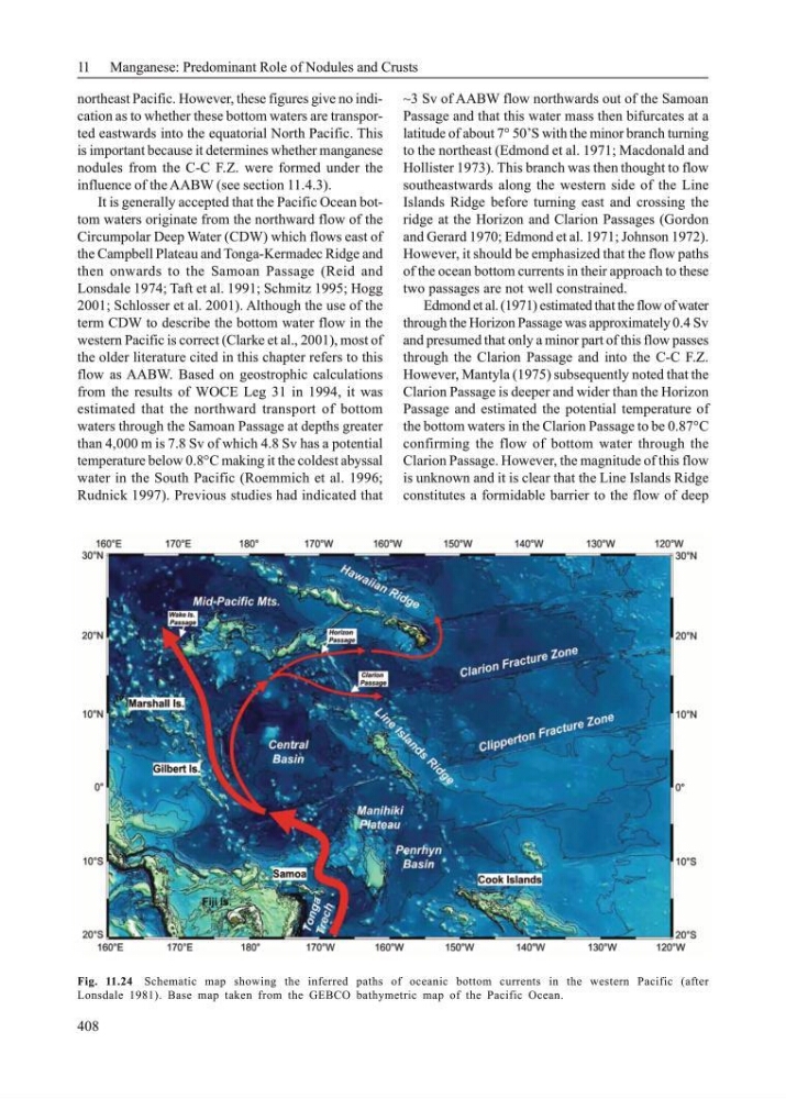
~3 Sv of AABW flow northwards out of the Samoan
Passage and that this water mass then bifurcates at a
latitude of about 7° 50’S with the minor branch turning
to the northeast (Edmond et al. 1971; Macdonald and
Hollister 1973). This branch was then thought to flow
southeastwards along the western side of the Line
Islands Ridge before turning east and crossing the
ridge at the Horizon and Clarion Passages (Gordon
and Gerard 1970; Edmond et al. 1971; Johnson 1972).
However, it should be emphasized that the flow paths
of the ocean bottom currents in their approach to these
two passages are not well constrained.
Edmond et al. (1971) estimated that the flow of water
through the Horizon Passage was approximately 0.4 Sv
and presumed that only a minor part of this flow passes
through the Clarion Passage and into the C-C F.Z.
However, Mantyla (1975) subsequently noted that the
Clarion Passage is deeper and wider than the Horizon
Passage and estimated the potential temperature of
the bottom waters in the Clarion Passage to be 0.87°C
confirming the flow of bottom water through the
Clarion Passage. However, the magnitude of this flow
is unknown and it is clear that the Line Islands Ridge
constitutes a formidable barrier to the flow of deep
Fig. 11.24 Schematic map showing the inferred paths of oceanic bottom currents in the western Pacific (after
Lonsdale 1981). Base map taken from the GEBCO bathymetric map of the Pacific Ocean.
11 Manganese: Predominant Role of Nodules and Crusts
northeast Pacific. However, these figures give no indication as to whether these bottom waters are transported eastwards into the equatorial North Pacific. This
is important because it determines whether manganese
nodules from the C-C F.Z. were formed under the
influence of the AABW (see section 11.4.3).
It is generally accepted that the Pacific Ocean bottom waters originate from the northward flow of the
Circumpolar Deep Water (CDW) which flows east of
the Campbell Plateau and Tonga-Kermadec Ridge and
then onwards to the Samoan Passage (Reid and
Lonsdale 1974; Taft et al. 1991; Schmitz 1995; Hogg
2001; Schlosser et al. 2001). Although the use of the
term CDW to describe the bottom water flow in the
western Pacific is correct (Clarke et al., 2001), most of
the older literature cited in this chapter refers to this
flow as AABW. Based on geostrophic calculations
from the results of WOCE Leg 31 in 1994, it was
estimated that the northward transport of bottom
waters through the Samoan Passage at depths greater
than 4,000 m is 7.8 Sv of which 4.8 Sv has a potential
temperature below 0.8°C making it the coldest abyssal
water in the South Pacific (Roemmich et al. 1996;
Rudnick 1997). Previous studies had indicated that
~3 Sv of AABW flow northwards out of the Samoan
Passage and that this water mass then bifurcates at a
latitude of about 7° 50’S with the minor branch turning
to the northeast (Edmond et al. 1971; Macdonald and
Hollister 1973). This branch was then thought to flow
southeastwards along the western side of the Line
Islands Ridge before turning east and crossing the
ridge at the Horizon and Clarion Passages (Gordon
and Gerard 1970; Edmond et al. 1971; Johnson 1972).
However, it should be emphasized that the flow paths
of the ocean bottom currents in their approach to these
two passages are not well constrained.
Edmond et al. (1971) estimated that the flow of water
through the Horizon Passage was approximately 0.4 Sv
and presumed that only a minor part of this flow passes
through the Clarion Passage and into the C-C F.Z.
However, Mantyla (1975) subsequently noted that the
Clarion Passage is deeper and wider than the Horizon
Passage and estimated the potential temperature of
the bottom waters in the Clarion Passage to be 0.87°C
confirming the flow of bottom water through the
Clarion Passage. However, the magnitude of this flow
is unknown and it is clear that the Line Islands Ridge
constitutes a formidable barrier to the flow of deep
Fig. 11.24 Schematic map showing the inferred paths of oceanic bottom currents in the western Pacific (after
Lonsdale 1981). Base map taken from the GEBCO bathymetric map of the Pacific Ocean.