

3 Possible Climate Change Impact on Groundwater
Discharge to the Bay of Puck, Southern Baltic Sea
3.1 Characterization of the Bay of Puck
The Bay of Puck is located in the southern part of the Baltic Sea (eastern part of the
Gulf of Gdańsk). A narrow, sandy spit called the Hel Peninsula, which is 36 km
long, separates the bay from the open waters of the Baltic Sea. The total area of the
Bay of Puck equals 359.2 km
2 . The catchment area is nearly three times larger and
equals 908.8 km
2 . The major rivers flowing to the Bay of Puck are Reda, Gizdepka,
Płutnica, Zagórska Struga and Chylonka. The total river inflow to the Bay of Puck
is equal to 0.25 km
3 year
−1 while the average precipitation equals 0.20 km
3 year
−1
(Cyberski and Szefer 1993). The Bay of Puck consists of an outer southeastern
region with an average depth of 20.5 m, and an inner northwestern region with the
average depth of 3.1 m. The basin slopes downward in a northeasterly direction
reaching the depth of 54 m near the tip of the Hel Peninsula (Cyberski and Szefer
1993). An average salinity in the Bay of Puck is in the range from 7.00 to 7.65
(Nowacki 1993).
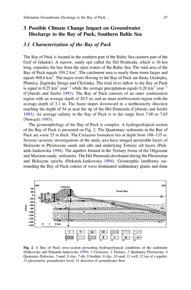
The geomorphology of the Bay of Puck is complex. A hydrogeological section
of the Bay of Puck is presented on Fig. 2. The Quaternary sediments in the Bay of
Puck are some 25 m thick. The Cretaceus formation lies at depth from 108–135 m.
Seismic–acoustic investigations of the study area have imaged permeable layers of
Holocene to Pleistocene sands and silts and underlying Tertiary silt layers (Piekarek-Jankowska 1994). The aquifers formed in the Tertiary forms of the Oligocene
and Miocene sandy, sediments. The Hel Peninsula developed during the Pleistocene
and Holocene epochs (Piekarek-Jankowska 1994). Geomorphic landforms surrounding the Bay of Puck consist of wave-dominated sedimentary plains and dune
Fig. 2 A Bay of Puck cross-section presenting hydrogeological conditions of the sediments
(Falkowska and Piekarek-Jankowska 1999). 1 Cretaceus, 2 Tertiary, 3 Quatenary-Pleistocene, 4
Quatenary-Holocene, 5 marl, 6 clay, 7 slit, 8 boulder, 9 clay, 10 sand, 11 well, 12 top of a aquifer,
13 piezometric groundwater level, 14 direction of groundwater flow
Submarine Groundwater Discharge to the Bay of Puck …
67
Discharge to the Bay of Puck, Southern Baltic Sea
3.1 Characterization of the Bay of Puck
The Bay of Puck is located in the southern part of the Baltic Sea (eastern part of the
Gulf of Gdańsk). A narrow, sandy spit called the Hel Peninsula, which is 36 km
long, separates the bay from the open waters of the Baltic Sea. The total area of the
Bay of Puck equals 359.2 km
2 . The catchment area is nearly three times larger and
equals 908.8 km
2 . The major rivers flowing to the Bay of Puck are Reda, Gizdepka,
Płutnica, Zagórska Struga and Chylonka. The total river inflow to the Bay of Puck
is equal to 0.25 km
3 year
−1 while the average precipitation equals 0.20 km
3 year
−1
(Cyberski and Szefer 1993). The Bay of Puck consists of an outer southeastern
region with an average depth of 20.5 m, and an inner northwestern region with the
average depth of 3.1 m. The basin slopes downward in a northeasterly direction
reaching the depth of 54 m near the tip of the Hel Peninsula (Cyberski and Szefer
1993). An average salinity in the Bay of Puck is in the range from 7.00 to 7.65
(Nowacki 1993).
The geomorphology of the Bay of Puck is complex. A hydrogeological section
of the Bay of Puck is presented on Fig. 2. The Quaternary sediments in the Bay of
Puck are some 25 m thick. The Cretaceus formation lies at depth from 108–135 m.
Seismic–acoustic investigations of the study area have imaged permeable layers of
Holocene to Pleistocene sands and silts and underlying Tertiary silt layers (Piekarek-Jankowska 1994). The aquifers formed in the Tertiary forms of the Oligocene
and Miocene sandy, sediments. The Hel Peninsula developed during the Pleistocene
and Holocene epochs (Piekarek-Jankowska 1994). Geomorphic landforms surrounding the Bay of Puck consist of wave-dominated sedimentary plains and dune
Fig. 2 A Bay of Puck cross-section presenting hydrogeological conditions of the sediments
(Falkowska and Piekarek-Jankowska 1999). 1 Cretaceus, 2 Tertiary, 3 Quatenary-Pleistocene, 4
Quatenary-Holocene, 5 marl, 6 clay, 7 slit, 8 boulder, 9 clay, 10 sand, 11 well, 12 top of a aquifer,
13 piezometric groundwater level, 14 direction of groundwater flow
Submarine Groundwater Discharge to the Bay of Puck …
67