

2.2 Submarine Groundwater Discharge in the Baltic Sea
Submarine groundwater discharge (SGD) is one of the water pathways connecting
land and ocean in the global water cycle. It has been recognized as an important
factor influencing coastal zones (Burnett et al. 2006).
Initially, investigations concerning groundwater system in the Baltic Sea Region
were limited to seawater intrusion into the Baltic Sea coast (e.g. Agopsowicz and
Pazdro 1964; Kolago 1964; Lidzbarski 2011). Later, scientists focused on
groundwater discharge into the Baltic Sea and hydrogeological conditions of the sea
bottom in different parts of the Baltic Sea. Thus, the lake-lands on morainic uplands
located along the southern Baltic Sea coast were identified as major SGD sources.
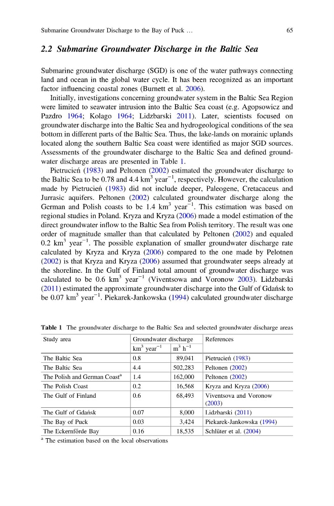
Assessments of the groundwater discharge to the Baltic Sea and defined groundwater discharge areas are presented in Table 1.
Pietrucień (1983) and Peltonen (2002) estimated the groundwater discharge to
the Baltic Sea to be 0.78 and 4.4 km
3 year
−1 , respectively. However, the calculation
made by Pietrucień (1983) did not include deeper, Paleogene, Cretacaceus and
Jurrasic aquifers. Peltonen (2002) calculated groundwater discharge along the
German and Polish coasts to be 1.4 km
3 year
−1 . This estimation was based on
regional studies in Poland. Kryza and Kryza (2006) made a model estimation of the
direct groundwater inflow to the Baltic Sea from Polish territory. The result was one
order of magnitude smaller than that calculated by Peltonen (2002) and equaled
0.2 km
3 year
−1 . The possible explanation of smaller groundwater discharge rate
calculated by Kryza and Kryza (2006) compared to the one made by Pelotnen
(2002) is that Kryza and Kryza (2006) assumed that groundwater seeps already at
the shoreline. In the Gulf of Finland total amount of groundwater discharge was
calculated to be 0.6 km
3 year
−1 (Viventsowa and Voronow 2003). Lidzbarski
(2011) estimated the approximate groundwater discharge into the Gulf of Gdańsk to
be 0.07 km
3 year
−1 . Piekarek-Jankowska (1994) calculated groundwater discharge
Table 1 The groundwater discharge to the Baltic Sea and selected groundwater discharge areas
Study area
Groundwater discharge
References
km
3 year
−1
m
3 h
−1
The Baltic Sea
0.8
89,041
Pietrucień (1983)
The Baltic Sea
4.4
502,283
Peltonen (2002)
The Polish and German Coast
a
1.4
162,000
Peltonen (2002)
The Polish Coast
0.2
16,568
Kryza and Kryza (2006)
The Gulf of Finland
0.6
68,493
Viventsova and Voronow
(2003)
The Gulf of Gdańsk
0.07
8,000
Lidzbarski (2011)
The Bay of Puck
0.03
3,424
Piekarek-Jankowska (1994)
The Eckernfőrde Bay
0.16
18,535
Schlüter et al. (2004)
a The estimation based on the local observations
Submarine Groundwater Discharge to the Bay of Puck …
65
Submarine groundwater discharge (SGD) is one of the water pathways connecting
land and ocean in the global water cycle. It has been recognized as an important
factor influencing coastal zones (Burnett et al. 2006).
Initially, investigations concerning groundwater system in the Baltic Sea Region
were limited to seawater intrusion into the Baltic Sea coast (e.g. Agopsowicz and
Pazdro 1964; Kolago 1964; Lidzbarski 2011). Later, scientists focused on
groundwater discharge into the Baltic Sea and hydrogeological conditions of the sea
bottom in different parts of the Baltic Sea. Thus, the lake-lands on morainic uplands
located along the southern Baltic Sea coast were identified as major SGD sources.
Assessments of the groundwater discharge to the Baltic Sea and defined groundwater discharge areas are presented in Table 1.
Pietrucień (1983) and Peltonen (2002) estimated the groundwater discharge to
the Baltic Sea to be 0.78 and 4.4 km
3 year
−1 , respectively. However, the calculation
made by Pietrucień (1983) did not include deeper, Paleogene, Cretacaceus and
Jurrasic aquifers. Peltonen (2002) calculated groundwater discharge along the
German and Polish coasts to be 1.4 km
3 year
−1 . This estimation was based on
regional studies in Poland. Kryza and Kryza (2006) made a model estimation of the
direct groundwater inflow to the Baltic Sea from Polish territory. The result was one
order of magnitude smaller than that calculated by Peltonen (2002) and equaled
0.2 km
3 year
−1 . The possible explanation of smaller groundwater discharge rate
calculated by Kryza and Kryza (2006) compared to the one made by Pelotnen
(2002) is that Kryza and Kryza (2006) assumed that groundwater seeps already at
the shoreline. In the Gulf of Finland total amount of groundwater discharge was
calculated to be 0.6 km
3 year
−1 (Viventsowa and Voronow 2003). Lidzbarski
(2011) estimated the approximate groundwater discharge into the Gulf of Gdańsk to
be 0.07 km
3 year
−1 . Piekarek-Jankowska (1994) calculated groundwater discharge
Table 1 The groundwater discharge to the Baltic Sea and selected groundwater discharge areas
Study area
Groundwater discharge
References
km
3 year
−1
m
3 h
−1
The Baltic Sea
0.8
89,041
Pietrucień (1983)
The Baltic Sea
4.4
502,283
Peltonen (2002)
The Polish and German Coast
a
1.4
162,000
Peltonen (2002)
The Polish Coast
0.2
16,568
Kryza and Kryza (2006)
The Gulf of Finland
0.6
68,493
Viventsova and Voronow
(2003)
The Gulf of Gdańsk
0.07
8,000
Lidzbarski (2011)
The Bay of Puck
0.03
3,424
Piekarek-Jankowska (1994)
The Eckernfőrde Bay
0.16
18,535
Schlüter et al. (2004)
a The estimation based on the local observations
Submarine Groundwater Discharge to the Bay of Puck …
65