

594
J. Noll
dynamics and in particular on water and energy cycles in order to determine the total radiation.
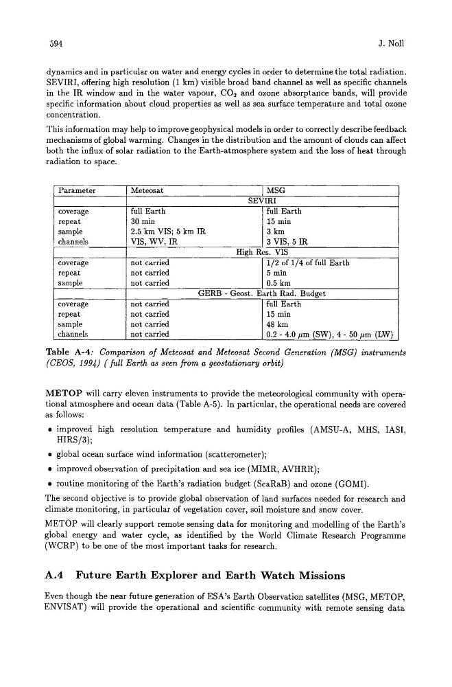
SEVIRI, offering high resolution (1 km) visible broad band channel as well as specific channels
in the IR window and in the water vapour, CO2 and ozone absorptance bands, will provide
specific information about cloud properties as well as sea surface temperature and total ozone
concentration.
This information may help to improve geophysical models in order to correctly describe feedback
mechanisms of global warming. Changes in the distribution and the amount of clouds can affect
both the influx of solar radiation to the Earth-atmosphere system and the loss of heat through
radiation to space.
Parameter
Meteosat
MSG
SEVIRI
coverage
full Earth
full Earth
repeat
30 min
15 min
sample
2.5 km VISj 5 km IR
3 km
channels
VIS, WV, IR
3 VIS, 5 IR
High Res. VIS
coverage
not carried
1/2 of 1/4 offull Earth
repeat
not carried
5 min
sample
not carried
0.5 km
GERB - Geost. Earth Rad. Budget
coverage
not carried
full Earth
repeat
not carried
15 min
sample
not carried
48 km
channels
not carried
0.2 - 4.0 11m (SW), 4 - 50 11m (LW)
Table A-4: Comparison of Meteosat and Meteosat Second Generation (MSG) instruments
(CEOS, 1994) ( full Earth as seen from a geostationary orbit)
METOP will carry eleven instruments to provide the meteorological community with operational atmosphere and ocean data (Table A-5). In particular, the operational needs are covered
as follows:
• improved high resolution temperature and humidity profiles (AMSU-A,MHS, IASI,
HIRSj3)j
• global ocean surface wind information (scatterometer)j
• improved observation of precipitation and sea ice (MIMR, AVHRR)j
• routine monitoring of the Earth's radiation budget (ScaRaB) and ozone (GOMI).
The second objective is to provide global observation of land surfaces needed for research and
climate monitoring, in particular of vegetation cover, soil moisture and snow cover.
METOP will clearly support remote sensing data for monitoring and modelling of the Earth's
global energy and water cycle, as identified by the World Climate Research Programme
(WCRP) to be one of the most important tasks for research.
A.4 Future Earth Explorer and Earth Watch Missions
Even though the near future generation of ESA's Earth Observation satellites (MSG, METOP,
ENVISAT) will provide the operational and scientific community with remote sensing data